Westford Listings on the National Register of Historic Places
The National Register of Historic Places
The National Register of Historic Places is a listing of buildings, structures, sites, objects and districts significant in our nation’s history, culture, architecture or archaeology and that are worthy of preservation. It is a federal designation, administered by the Secretary of the Interior through the Massachusetts Historical Commission as the State Historic Preservation Office. Listing in the National Register provides formal recognition of the property’s significance, certain federal tax incentives for owners of income-producing property, and limited protection from federally funded, licensed or assisted projects. In addition, listing on the National Register can provide some exemptions from the state building code.
National Register listing in no way limits the owner’s use of the property and places absolutely no restrictions or conditions on changes made by a private property owner unless there is state or federal involvement in a project or unless some other regional or local regulation is in effect. Nominations to the National Register are usually initiated by a property owner or by the local historic commission and do not require any local government approval. Property owners have the right to object to listing on the National Register, and a district will not be listed if the majority of the owners object.
The National Register should not be confused with a Local Historic District, which may be established by towns to preserve the unique characteristics of a certain area and may require review of exterior changes to a building by a Local Historic District Commission. Westford has no Local Historic Districts.
Properties listed on the National Register are also automatically included on the State Register of Historic Places. This provides limited protection from adverse effects by state funded, licensed or assisted projects. More importantly, it enhances the opportunity for owners of municipal or private nonprofit properties to apply for 50% matching state grants through the Massachusetts Preservation Projects Fund.
As early as 1976, in its second year of existence, the Westford Historical Commission began the process to place Westford Center on the National Register of Historic Places. This work culminated on August 28, 1998, when Westford Center was placed on the National Register by the Department of the Interior’s, Parks and Services Office, Washington, D.C. Listing on the National Register is accomplished by completing a detailed nomination form (NPS Form 10-900) that describes in some detail the historic, architectural and cultural features of the site. The following list names the sites that Historical Commission has nominated and the status of each nomination. Links are provided to extracts from the nominations for each site. They provide a nice overview of the history of each site with some biographical information on persons associated with each site. Copies of the complete nominations are available at the J. V. Fletcher Library and the Westford Museum.
|
Site |
Status |
|
Westford Center Historic
District |
Listed on National
Register August 28, 1998 |
|
Graniteville Historic
District |
Listed on National
Register January 17, 2002 |
|
Forge Village Historic
District |
Listed on National
Register May 2, 2002 |
|
Brookside Historic
District |
Listed on National
Register January 23, 2003 |
|
Parker Village Historic
District |
Listed on National
Register December 27, 2002 |
|
Fairview Cemetery |
Nomination sent to state
May 2002 |
|
Westlawn Cemetery |
Nomination sent to state
May 2002 |
|
Hillside Cemetery |
Nomination in progress,
submit to state June 2003 |
|
Wright Cemetery |
Nomination in progress,
submit to state June 2003 |
|
Russian Cemetery |
Nomination in progress,
submit to state June 2003 |
|
John Proctor House, 218
Concord Road |
Listed on the National
Register February 4, 1993 |
|
Henry Fletcher House &
Barn, 224 Concord Road |
Listed on the National
Register September 30, 1993 |
Westford Center Historic District
Westford Center Historic District was accepted for listing on the National Register on August 28, 1998, culminating work of the Westford Historical Commission going back to 1976. Copies of the complete nomination document, prepared by Sanford Johnson, Historic Preservation Consultant, and sponsored by the Westford Historical Commission, may be found in the J. V. Fletcher Library and at Westford Town Hall. Following is an abstract from that document. The original document contains more detailed information on the architectural characteristics of individual buildings.
Description
Westford Center is the residential and civic center of the town of Westford, Massachusetts. Architectural resources consist of moderately to well preserved institutional, residential and commercial properties constructed from the Colonial to the Early Modern Periods. The historic district is comprised mainly of residential buildings and contains a church, historic former parish hall, library, town hall, police/fire station, museum, the town common, and three commercial structures. One hundred three buildings comprise the district. Of these, ninety-four are contributing elements and continue to associate the district with its historic trends of development. The historic appearance of these buildings is enhanced by the presence of many historic outbuildings, stone walls and gateposts. Architectural styles include Colonial, Georgian, Federal, Greek Revival, Italianate, Second Empire, Stick, Queen Anne, Shingle, Richardsonian Romanesque, Colonial Revival, Craftsman Bungalow, and English Revival. In addition to the architectural resources, there are numerous outbuildings, twenty structures, three sites and seven objects. The boundaries are defined by changes in density of historic buildings and by topographic changes.
Westford Center is located on Tadmuck Hill, which is the town’s highest eminence at 460 feet above sea level and marks the approximate middle of the town. It is located in the coastal lowland region of Massachusetts approximately ten miles south of the border of New Hampshire and approximately thirty miles northwest of Boston. The town is bordered on the east by Chelmsford, on the south by Acton and Carlisle, on the west by Groton and Littleton and on the north by Tyngsborough. The area of the town is approximately thirty-one square miles. Many of the geologic formations in Westford are glacial in origin, including Tadmuck Hill.
The setting of the Center residential district consists of open fields formerly used for agriculture mixed with forested areas. Building lots are between approximately one-quarter and seven acres in size with most buildings located within fifty feet of roads. Moderately dense residential development lends the district a village appearance. The generally well maintained buildings are residential in scale and predominately wood in construction. Landscaping is generally traditional with well-maintained foundation plantings and ornamental trees appearing throughout the district. It is distinguished from other parts of town by its elevated location on Tadmuck Hill, density of construction, quality of architectural design, average higher age of buildings, their stylistic pretension, and it is the site of most civic activities and the town common. It is possible to view parts of New Hampshire, Worcester County and the City of Boston, all at least ten miles from Westford Center. The district retains integrity of location, design, setting, materials, workmanship, feeling and association.
Development
Westford Center began as a farming neighborhood in the 1720s when settlers, mainly from Chelmsford, built homes on Tadmuck Hill. In 1727, a church was established and the militia began training nearby. Land in the area was used mostly for residential and agricultural purposes through the eighteenth century, but the central location fostered construction of buildings for local government functions and other civic buildings such as churches and schools. Land use began to shift toward public functions after the initial First Parish Church building was constructed in 1727. The two uses coexisted for many years until the demise of the profitability of farming drastically curtailed agricultural land use in the mid twentieth century.
Many residences are located in the Center and were constructed by community leaders. For example, the manufacturer Allen Cameron occupied the house most recently used as a nursing home at 39 Main Street in the mid to late 1800s. Members of the Abbot Family lived in the House at 24 Main Street in the early 1800s. The Abbots were owners of the Abbot Worsted Company, employers of hundreds of Westford residents from 1878 to 1958. J. Henry Read lived at 30 Main Street ca. 1875. He was a prominent resident who served in town and state government in the late nineteenth century. 56 Main Street Ca. 1875 was the home of John Lanktree, tax collector, blacksmith and farmer during the late nineteenth century.
Many civic activities took place in the Center since its development as the core area of population. The earliest was the practice of religion at the First Parish Church, which is located to the north of Main Street. Services were first held on the site in 1727 and continue today in a building constructed in 1794, which stands just east of the site of the original structure. This building was reoriented in the late 1860s to face the common. The Westford Academy was established in 1793 and its building was located on Boston Road across from the Common. It was moved behind the Congregational church on Boston Road in the early twentieth century and served as a firehouse. It is currently used as a museum. The former Congregational Church separated from the First Parish Church in 1826 and constructed its own building in 1829 at the corner of Lincoln Street and Boston Road. This church was remodeled in 1896. It served as a church until the mid-twentieth century and parish hall for the First Parish Church until 1996. The Town Hall was built in 1870 and became the focus of town politics and continues to serve that purpose today. The J. V. Fletcher Library was built in 1895-1896 after the Town Hall was deemed too small to house the growing collection. It was enlarged in the early 1990s and still serves as the town public library. The trustees of Westford Academy constructed a second building to house the students in 1897. This was known as the Roudenbush School by the 1950s when it became a grade school and a new academy was built. It is now the Roudenbush Community Center. The W. E. Frost School was built in 1908 and served as a grade school until the 1980s. It is currently the Roudenbush Children’s Center at Frost.
Westford Center was also the site of some commercial activity. The earliest appears to have been a store established in 1762 on the north side of Main Street, west of the First Parish Church. The store is no longer standing. Other enterprises would follow, one of which was the Wright and Fletcher Store. This was housed in the building at 40 Main Street, which was built ca. 1840 and functioned until at least the early twentieth century. It is currently an art gallery. Another member of the Fletcher family ran a store at 6-8 Lincoln Street built ca. 1840, remodeled ca. 1905, which also stayed in business from the 1850s into the twentieth century.
The neighborhood of Westford Center surrounds the Common, which was sold to the town by Joseph Underwood in 1748 for use as a military training ground. As this type of use became less frequent, the Common was adapted to a park area for the residents and was used for Memorial Day and other civic celebrations. War veterans are memorialized here through statues, plaques and markers. Markers were placed here as early as 1899 when the cannon at the east end was installed. Other monuments followed. There is a bronze eagle commemorating war dead, water troughs of iron and granite and a stone monument to Col. John Robinson, Revolutionary War Veteran. There was a bandstand on the Common from the 1860s until around 1900. During this period, the Common was the site of civic celebrations on Memorial Day and to dedicate the library, the Civil War Memorial and other improvements. It remains a cultural and civic point of focus as well as a recreational resource. Attempts to improve landscaping were made in the nineteenth century by planting trees in a double row along the perimeter of the Common. Other improvements were made around 1919 when landscape architect Bremer Pond was contracted to design a more formal common green. This resulted in curbing at the edges, leveling and planting grass.
The majority of the remaining structures in the Center are residential and were constructed from the Colonial to the Early Modern period. Some modern construction is found on Main Street, Boston Road, and in five subdivisions around the Center. The modern construction is consistent with historic residential construction in terms of scale, materials and style. Current residents tend to work as professionals, and agricultural land use has been relegated to outlying areas of the town.
Public Spaces
The Common is a level triangular piece of ground originally used as a military training field that now serves as a park and is the site of monuments, statues and a flagpole. It is bounded on the east by Lincoln Street, the northwest by Main Street and the southwest by Boston Road. It occupies approximately one acre and is planted with grass, tress and shrubs. Markers were placed here as early as 1899 when the cannon at the east end was installed. Other monuments followed. There is a bronze eagle commemorating war dead, water troughs of iron and granite and a stone monument to Col. John Robinson, Revolutionary War Veteran. There was a bandstand on the Common from the 1860s until around 1900. During this period, the Common was the site of civic celebrations on Memorial Day and to dedicate the library, the Civil War Memorial and other improvements. The Common is currently used as a recreational area.
The Whitney Playground, established 1910, is located in Westford Center between William E. Frost School and the Roudenbush School. It is a hilltop site with a view to the south. Structures on the playground include ballfields, children’s playground structures, tennis courts and maintenance sheds. A random ashlar granite block retaining wall approximately five feet in height separates the Roudenbush building from the playground. A row of lilacs is adjacent to the south portion of the wall. The location of the playground between the two former schools is indicative of the original use of the parcel, which was to accommodate outdoor activities of residents.
Public Buildings
The oldest public building in Westford Center is the first Westford Academy building, constructed in 1793, which now houses the Westford Museum. It is a Georgian building with a rectangular two-story form of three bays’ width and six bays’ depth. It is a wood-frame structure with a wood shingle roof, wood clapboard siding and a cut granite foundation. The ridge-hip roof has at its center an octagonal belfry with an ogee-form copper roof and weathervane. A hip roof center entry porch with Classical details is attached to the façade. Windows are 12/12 double-hung sashes with molded trim and hoods at the first story. The entry is simply trimmed and has transom lights above. A single brick chimney is in the rear of the roof. Georgian ornament includes the eight arches with wood keystone details supporting the belfry, the balustrade and Classical cornice with dentils surrounding the belfry base, Classical cornice with dentils at the eave of the building, Classical trim on the entry porch which consists of a denticulated entablature and Corinthian columns and wood corner quoins. A gazebo of twentieth century construction housing a commemorative bell is north of the museum. The building has been restored to its 1793 appearance. The restoration was a gradual process over the last twenty years for use as a historical museum. It was moved from a site 1/10 mile to the east in 1910 by the town for use as a fire station. A gazebo of twentieth century construction housing a commemorative bell is north of the museum. It is in good condition.
A year after the construction of the Academy, the third building to house Westford’s First Parish Church was erected at 48 Main Street. It is a Georgian style wood frame, three by four bay, front-gable structure of two stories with a three-story tower attached to the façade. The roof is clad in asphalt shingles, the walls in wood clapboard and the foundation is built of cut granite. The tower is a square form in the center of the façade which contains the front double leaf entry at ground level, a six pane, fixed sash above and two 6/3 double-hung sashes above that. A clock is between the top window and the belfry. An octagonal belfry with dentils around the base and eight segmental arches with keystones rests atop the tower. The belfry is capped by a pointed, shingled rook with weathervane. Windows on the second story of the main block of the church are 9/9 double-hung sashes placed immediately below the eave. Those on the first story are 6/6 double-hung sashes and have hipped hoods. The façade is lit by two 6/6 double-hung windows on the second story. The center entry is lit by a large fanlight and is protected by a gable roof entry porch. An interior brick chimney is near the rear of the building. Decorative elements include the dentils in the gable peak of the entry porch, modillions at the building eaves, gable returns, molded cornices and a gold weathervane with a banner and arrow design on top of the spire. The immediately adjacent Parish Hall was built in 1996 and encroaches deeply upon the front yard of the church. First Parish Church is Westford’s most historically significant architectural resource.
A schism within the First Parish Church resulted in the construction of the former Congregational Church in 1829 (remodeled in 1896, formerly the parish hall serving the First Parish Church from the 1950s until 1996). It is a two story, wood-frame building built in the Late Victorian style. The main block is a rectangular front-gable form of three by three bays. Side ells are attached to the east and west walls and a wide, square tower with pyramidal roof is located at the northwest corner. The roof is clad in asphalt shingles, the walls in wood clapboards and the foundation is built of cut granite. A variety of windows exists. The façade has a large paired round-headed stained glass window in the center with an oculus and round hood molding. Others on the façade are the shingle round-headed stained glass on the east side and a rectangular stained glass window with a round hood on the west side of the façade. Other walls exhibit similar arrangements of window types. The entry is recessed under a wood Romanesque arch. A stained glass transom light reads 1829-1896 and was probably installed at the time of remodeling in the latter year. A single brick chimney is near the rear of the church. Ornament consists of the Romanesque entry, the pyramidal tower, round hood moldings over stained glass windows. The Congregational Church was remodeled into a front-gable Late Victorian style building and retains its design association to this period. It is in good condition.
The end of the Early Industrial Period saw the construction of the Town Hall at 55 Main Street (1870). The building is a three by six bay, rectangular, two and one-half story front-gable form. It is a wood-frame structure with an asphalt shingle roof, wood clapboard siding and a cut granite foundation. A three-story tower with belfry is attached to the façade. The Town Hall is attached at the southwest corner to the Police/Fire Station, built in 1974. Windows are 6/6 double-hung sash with segmental arch hoods at the first floor and flat hoods at the second story. Windows on the façade are paired sashes with double segmental arch hoods. The front entry is in the base of the tower and is covered by a flat roof porch with balustrade above and Colonial Revival columns at the sides. A brick chimney is at the northwest corner of the roof. Ornamental elements include a wide frieze, brackets at the eaves on the rear of the building and an oculus on the second story of the front of the tower. The building was enlarged by one bay at the rear in the late nineteenth century. The original Second Empire tower was destroyed in the 1938 hurricane and the present Colonial Revival tower with a domed roof belfry was added at that time. The Town Hall is in excellent condition.
In 1875 the town contracted for the construction of a new District #1 school at 20 Boston Road. It is a Second Empire design two stories in height, three bays in width and three bays deep. A Mansard roof is the dominant design characteristic of the structure. Pedimented dormers are found in the secondary slope of the roof and a brick chimney is at the center. A center gable dormer is above the entry hood, which is in the center of the first story. Windows on the first floor have projecting hood moldings but otherwise the surrounds are fairly simple. Second floor windows are inset dormers and have pilasters at the sides and stylized Classical ornament at the hood. A frieze board and paired brackets are located at the eaves. A decorative shield is situated in the middle of the gable dormer on the second story of the façade. The entry is protected by an ornate flat roof entry hood with paired brackets at the cornice and curvilinear brackets at the sides. The building was adapted for use as a residence in 1995 and retains its Second Empire design features.
Trends in philanthropy at the close of the nineteenth century led to the construction of the J. V. Fletcher Library at 50 Main Street in 1895. It is a three bay Late Victorian design executed by architect H. M. Francis, primarily in stone and buff colored brick. It is a two-story, three-bay, ridge-hip roof structure with a projecting central bay surmounted by a closed gable. Gabled dormers are located on each side slope of the roof. The roof is clad in slate and the walls are built of buff colored brick. The building rests on an elevated foundation of cut granite and rubble stone construction. Wall trim consists of a cut stone string course between the floors, wide cut stone eave trim and a copper cornice ornamented with an egg and dart pattern. First floor windows are trimmed with flat arches of brick. The recessed entry is ornamented with a terra cotta and cut granite block surround marked with the date 1895, a keystone atop the arch, and Arts and Crafts style floral motif. Brick chimneys with corbel caps are located at each side slope of the roof. An early 1990’s addition consists of matching two story wings of buff colored brick and little other ornament. The wings approximately double the size of the structure and maintain the character of design established by the original. They are two bays in width and two stories tall. The only ornament is a beltcourse of soldier bricks between the floors. Windows and eaves are unornamented. The library is the only building in the Center built completely of brick. It is comparable to no other structure in town in terms of design and is one of the most valuable architectural assets of the town of Westford.
Immediately after the library was built with privately donated funds, the town saw fit to erect the building at 65 Main Street, which is the exuberant Late Victorian style Roudenbush School. It replaced the 1793 Westford Academy building in 1897 and served that function until 1955. It currently serves as a community center. The richly ornamented wood-frame building is a rectangular, three by seven bay, two and one-half story form with a hip roof and projecting central gable. A one story Colonial Revival ell is attached at the rear and houses a gymnasium. The roof is clad in slate shingles, the walls primarily in wood shingles, and the foundation is build of random coursed granite ashlar. Secondary gable roof entry porches give access to the basement level on the east and west sides. A variety of windows exists on the building. The peak of the projecting central gable is lit by three round-head, four-pane ribbon windows that are divided by colonettes. The frieze has five fixed sash of eight panes in the projecting gable and one on each side of the main block of the building. Immediately below the sash in the frieze are five 4/1 double-hung sash in the projecting gable and 6/1 double-hung sash on the main block. The first story is lit with a 6/1 double-hung sash on both sides of the main block. Large multiple pane sash with Romanesque hood moldings are located between floors on the east and west sides. A Richardsonian Romanesque arch built of wood that is cut to resemble stone vussoirs marks the recessed center entry on the first story of the projecting gable. The double leaf entry has a wide flanking band of fixed sashes and transom lights. A metal chimney and two hip roof dormers are on each side of the hip roof. Dormers are lit with 6/1 double-hung sash and are clad in slate shingles with copper flashing on the roof and wood shingles on the cheeks. A belfry occupies the peak of the hip roof. It rests on a square base and is supported by a round pinnacle at each corner. The domed copper roof is capped by a small spire with weathervane. The Roudenbush School has the widest array of ornament in the town of Westford. The belfry is articulated with a short, trabeated colonnade above an arch at each of its four sides. The pinnacles are capped with copper finials and grotesques. The spire atop the belfry has colonettes supporting a slender pyramidal roof. The eaves of the building have modillions above a shingled frieze and a row of dentils. The walls above the water table are clad in a wide band of beaded flushboard siding. The entry arch has dentils at the extrados, egg and dart molding at the intrados and rosettes at the springing line. Basement level entry porches have gable roofs supported by grouped colonettes and pilasters that rest on random coursed granite ashlar knee walls. The peaks of the gables are enclosed with wood screens. Classical molding and gable returns further articulate the porches. The building was enlarged at the rear in approximately 1930 with a one story gymnasium that is fenestrated with round head windows with Colonial Revival molding and keystones. The building is in excellent condition and retains its original design intent.
Late Industrial Period public building culminated in construction of the Frost School in 1908, which was intended to house the conglomerated school districts. Designed by Carl V. Badger, 73 Main Street is a two story, three by five bay Colonial Revival structure with a ridge-hip roof. It is a rectangular building with a projecting central bay on the façade. Entries flank the bay and are protected by flat roof, one-story porches with full entablatures at the cornice. The porches are supported by grouped columns at the corners, which rest on plinth blocks. A one-story, three-sided bay window is at the center of the first floor of the façade. A pedimented dormer is located on the front slope of the roof. The structure is clad in wood clapboard, the roof is sheathed in slate and copper and the foundation is built of cut granite. Eaves are deep and have wide frieze boards. Walls are trimmed with spandrel panels below the two story compass windows at each side of the projecting bay and slim pilasters are at the corners of the building. The compass windows are surrounded by classical trim with keystones at the top. Other windows are 6/6 double-hung sash with plain surrounds. Entries are located under the side porches and have plain surrounds. An interior brick chimney is at the center ridge of the roof and two metal ventilators are at the rear slope of the roof. Two prefabricated tool sheds, a fence, and a playground are adjacent to the building. Other period school buildings include the 1897 Roudenbush School, which is larger and designed in a more ornate Victorian Eclectic style.
A modern civic building constructed in approximately 1974 at the north end of the Common houses the Police and Fire Departments (non-contributing). 51-53 Main Street houses firefighting apparatus in the two-story front-gable structure comprising the west side of the building and police functions in the east-side one-story ell. The late twentieth century structure is clad in wood clapboard and has a concrete foundation. Shed roof towers mark the roofline at the east and west slopes of the front-gable roof. Ornament consists of the lunette in the peak of the gable over the metal roll-up doors that admit fire vehicles. The building is in good condition.
Commercial Buildings
The oldest surviving commercial building in Westford Center is the former Fletcher Store, built ca. 1840, at 40 Main Street, which is a combination of residential and commercial space. The two and one-half story, front-gable main block is joined at the rear of the west wall to a large two-story side-gable ell that forms an L-shaped plan. The front-gable façade is two bays across with each bay containing two windows at the second floor and a projecting bay window at the first. The bay windows at the façade are intended to display commercial goods and are connected above by a hip roof, which forms a recessed center entry. A small two-story ell is located at the intersection of the two rectangular blocks of the building. It is lit on the south side by a roundel and on the west side by a 6/6 double-hung sash, both at the second story. An unornamented entry is on the south side of the first floor of the ell. The larger two-story ell has a second story flat roof porch on the front with a screened knee wall and carved brackets and posts. Diagonal knee braces support the porch from below. Windows are generally 6/6 double-hung sashes except the roundel and the large fixed panes in the bays. The center entry is unornamented. There are two interior brick chimneys and a modern skylight in the roof. Much original ornament has been removed although the closed gable remains.
The most prominent commercial building faces the south side of the Common. 6-8 Lincoln Street, ca. 1840, remodeled ca. 1905, is an accreted, wood-frame, two and one-half story Queen Anne style building with a complex plan that contains several dwelling units and professional offices. The building was formerly a store and residential/commercial structure that was enlarged at the start of the twentieth century with a wide porch on the façade and an octagonal tower on the east side of the façade. It is seven bays wide and four bays deep. The roof is clad in slate shingles, the walls in wood clapboards and the foundation is built of cut granite and cast block under the tower and porch. A ¾-width, one-story shed roof porch is attached to the façade between the tower and the gable-front block. A second shed roof porch is at the rear of the residential section of the building. Windows are 2/2 double-hung sashes except at the roof level of the tower, which is lit by short 6/1 double-hung sashes. The center entry is a double leaf arrangement located under the low pedimented gable on the front porch. A second entry is recessed into the canted west corner of the building. Two interior brick chimneys are near the rear of the building. A single gable dormer is located on the front slope of the side-gable block and is lit by a Palladian window. Decorative elements consist of the wide cornice and frieze, corner pilasters, eave brackets, short gable returns, a spindle frieze, turned posts, carved brackets and Arts and Crafts ornament on the front porch. The building retains most of its historical fabric and its associations with nineteenth century residential/commercial architecture. It is in good condition.
Two Early Modern Period commercial buildings exist in the district. 2 Depot Street, ca. 1945, is a Colonial Revival style building in use as a telephone service facility. The rectangular six by one bay brick structure is one story high and has a large brick addition attached to the rear. The side-gable roof is clad in asphalt shingles, the walls are brick and the foundation is concrete. Windows are 6/6 double-hung sashes trimmed with brick flat arches and sills. The front entry is trimmed with a Colonial Revival surround. A single brick chimney with a copper cap marks the roofline. Decorative elements include gable returns and a molded cornice. The addition in the rear is also a brick side-gable structure and is connected by a small ell. 45 Main Street, ca. 1930, is the former post office and has been converted for use as a bank. The Colonial Revival brick structure is a one story, side gable, rectangular form with a flat-roof rear ell. It is five bays wide by four bays deep. Windows are 6/9 double-hung sashes with brick sills, shutters and no other trim. The center entry is trimmed in Classical molding with a transom above. An ornamental ventilator with louvered vents and a pyramidal roof occupies the middle of the ridgeline. Other ornament consists of a frieze that acts as a signboard, brick quoins and gable returns. A chain link fence separates the property from its neighbor to the west. The front, rear and west side yards are paved for parking.
Colonial Period, Pre 1775
Few Colonial Period residences survive in the district. Most houses constructed before 1775 have either been lost to fire, moved out of the district or subsumed under later construction and are no longer recognizable as Colonial buildings. A visible example is at 3 Depot Street, built in approximately 1730. It is a two and one-half story, side-gable, three by two bay residence with a one and one-half story ell on the south side wall connecting to a barn at the rear. A pedimented porch projects from the façade over the center entry. It is sided with wood clapboards and the roof is covered in asphalt shingles. The foundation is cut granite. The vernacular building is nearly devoid of ornament. A slim plain return marks the eaveline on the gable end. Narrow corner boards and a plain cornice constitute the remainder of the trim. Windows are primarily 6/9 double-hung sash with 6/6 double-hung units and a fixed six-pane sash in the ell. Sidelights, pilasters and columns flank the entry. The barn is an attached, side-gable structure, one and one-half stories in height with two vehicle entries. Windows on the façade are six-pane fixed sash. The roof is asphalt shingle, the siding is wood clapboard and the foundation is rubblestone. An ell is attached at the rear. 3 Depot Street is an early structure in Westford Center that retains integrity of design, location and association.
Another significant Colonial house is 2 Hildreth Street, ca. 1713, the oldest building in the district. This is a two and one-half story, side-gable, five bay Colonial style residence. Ells are located at the south side and at the rear of the building. It is a wood-frame structure clad in wood clapboard with a slate roof. Ornament is limited to the entry surround, which is articulated by full-length sidelights and a simple molding. There is a one-story bay window at the rear of the house and a gable dormer on the roof of the side ell. Windows are 6/9 double-hung sash with simple trim. Two brick chimneys with corbel caps are located on the ridge of the main block of the building.
The third surviving Colonial residence is the Charles Fletcher House at 62 Main Street, 1740-1780. It is a two and one-half story, five bay, side-gable Colonial house. One-story ells are located at each side of the building and a one-story bay window is at the west side of the first floor. The roof is clad in asphalt shingles, the walls in wood clapboard, and the foundation is built of cut granite. The most prominent ornamental detail is the entry surround which is Federal in style. It consists of a denticulated cornice over a wide frieze board, Ionic pilasters at the sides, three quarter length sidelights and a fanlight above the door. Windows are 2/2 double-hung units with narrow, simple surrounds. Eaves have narrow trim boards and short gable returns. The five-sided bay window at the west wall is capped by a cornice and frieze board and has quarrel panes set in double-hung sash. Two brick chimneys rise from the ridge of the side gable roof. The significance of the Fletcher House lies in its design integrity and in its well-maintained condition.
Federal Period, 1775-1830
A great deal of development took place in Westford Center during the Federal Period and many residences survive to illustrate the methods of construction and design choices that residents made during the period. While few houses exhibit high style Federal form, several retain a moderate level of detail and association with the design concepts of the period.
1 Hildreth Street, ca. 1780, remodeled 1846, is a two and one-half story, five bay, side-gable residence. The ell to the rear of the main block of the house was built in 1790. The more formal Federal style front section was constructed in 1846. It is a wood-frame building constructed on a cut granite foundation with an asphalt shingle roof and wood clapboard siding. Eaves are articulated with a frieze board, 6/6 façade windows with wide surrounds, and the recessed entry is flanked by sidelights and surmounted by a transom. The sidewalls are marked by full gable returns. The barn at the rear is a one and one-half story, two bay, side-gable structure sided with wood clapboards. There are two vehicle entries and a gable dormer on the façade. 1 Hildreth Street is similar in scale and design to 72 Main Street and presents a well-maintained façade to the Common and to the Civil War Memorial.
7 Hildreth Street, ca. 1830, is a rectangular Federal style dwelling. It is a side-gable, two and one-half story, five by two bay, wood-frame building with an asphalt shingle roof, wood clapboard siding and a cut granite foundation. An attached shed and two bay garage are at the rear of the house. Windows are 12/12 double-hung sash with molded surrounds and shutters. A square bay window with a wood shingled hip roof and a multiple-pane picture window occupies the south side of the first story. The center entry is a high style Federal design with full entablature, dentils, pilasters and sidelights. The fanlight depicts an eagle rendered in leaded art glass. Brick chimneys are at the north side and in the center of the roofline. Other ornament includes slim corner boards and cornice and a water table. The attached barn is a front-gable, two-story, two bay structure converted for use as a garage. A cut granite and uncut granite wall separates the front yard from the street. The house is unaltered except for the bay window and is in good condition.
4 Leland Road, ca. 1794, is a two and one-half story, six bay, side-gable, Federal style with two ells at the rear. Walls are clad in wood clapboard, the roof in asphalt shingles and the foundation is built of cut granite. Two brick chimneys rise from the main part of the roof and a third chimney is located in the first ell. A large porch with a rounded corner pavilion extends from the façade around to the eastern side of the house. A carriage porch surmounted by a balustrade and an enclosed porch projects from the front of the building, covering a portion of the driveway. The large porch and carriage porch are of Colonial Revival design and were added well after the original section of the building was completed. A second, smaller porch is located at the west side of the first rear ell. Ornament on the earlier portions of the house is restrained. Windows are 6/6 double-hung sash with simple surrounds. The main entry appears to have been remodeled around the time the porches were added. It is surrounded by simple bead moldings with circular bosses at the corners. Eave trim is minimal. The barns are located close behind the house. The closer of the two is a large side-gable form oriented parallel to the main block of the house. The second barn is smaller and is oriented in the same direction. Both are clad in clapboard and have granite foundations. Wide stone walls surround the property. 4 Leland Road has the most ornate porch example and one of the few carriage porches in Westford.
24 Main Street, ca. 1820, is the most formal Federal style house in the district. It is three stories in height, five bays in width and four in depth. The roof is a ridge-hip form with two chimneys at each side. An ell is located on the west wall, connecting the house to the barn. A hip roof, one-story porch projects from the façade over the center entry. The main exterior materials are wood clapboard on the façade and brick on the sidewalls. The roof is sheathed in asphalt. Federal style ornament is seen in the dentils at the eaves, the simple hood moldings over the 12/12 double-hung sash, the Doric pilasters at the corners of the main block of the building, and in the Classical lines of the entry porch, which is supported by Doric columns at the corners. The symmetry of the façade and the reduction in size of the third floor façade windows to 8/12 panes are the most characteristic Federal elements. This is the purest example of Federal design in Westford and makes a major aesthetic contribution to the center of the town. The attached ban is a front-gable, one and one-half story clapboard structure with a central vehicle entry. There is a roundel in the façade gable peak and other secondary openings placed across the façade. A square ventilator with louvered vents, bracketed eaves and a weathervane is located at the middle of the roof peak.
Early Industrial Period, 1830-1870
Residential development during the Federal Period continues to lend the district much of its character and sense of place, but a large number of buildings also survive from the Early Industrial Period. These contribute to the historical associations embodied in Westford Center due to their number, quality of design and high degree of preservation. Several of the Early Industrial Period houses exhibit Federal style elements from the mid nineteenth century. Others have Greek Revival elements and still others have few or no distinct stylistic elements.
24 Boston Road, 1843, is a five by one bay, two and one-half story, side-gable residence with some elements of the Federal style. There is a large ell that connects the main block of the house to the barn at the rear. A shed roof porch of one story is attached at the south side of the ell. A secondary one-story ell projects from the north wall of the house. The house is clad in wood clapboard, the roof is sheathed in asphalt and the foundation is built of cut granite. Ornamental elements are found at the entry, which has a wide surround, ¾ sidelights and transom lights. Windows are 6/6 double-hung sash and the surrounds are narrow and simple. The long ell at the rear is oriented perpendicular to the main block of the house and is lit by a variety of sash types. The porch is supported by three paired posts and extends slightly more than half the distance to the barn at the rear. The front-gable one and one-half story barn has a single vehicle opening and a double-hung window in the peak. It is clad in wood clapboard, the roof in asphalt and the foundation is built of cut and uncut granite. A wellhouse is located in the dooryard. 24 Boston Road is a typical local example of the Federal style. It is well maintained and comparable in scale and design to others in town such as 36 Main Street.
25 Boston Road, ca. 1840, is a wood-frame dwelling with Federal style elements located in the Westford Center residential district. The plan is a rectangular, three by two bay, two story form with a two story rear ell. The roof is clad in asphalt shingles, the walls in wood clapboard and the foundation is built of cut granite. The side-gable roof is marked by two side chimneys and a widow’s walk. A rear one-story shed porch is on the south side of the rear ell. Windows are 6/6 double-hung sashes with tall hood moldings and shutters. The center entry is lit by side and transom lights and has a hood supported by carved brackets. The chimneys are ornamented with corbel caps and the widow’s walk has a plain balustrade and an oculus in the base. An attached shed was built onto the rear of the building in the late twentieth century. A post and rail fence and a stone wall are in the front and side yards.
5 Depot Street, ca. 1840, is another wood-frame dwelling with Federal elements built in the early Industrial Period. It is a rectangular, five by one bay, two and one-half story house with a one and one-half story side ell. The side-gable roof is clad in asphalt shingles, the walls in wood clapboard and the foundation is built of cut granite. Windows are 6/6 double-hung units with simple trim. The entry has wide trim and ½-length sidelights. A single center brick chimney is in the roof of the ell. A secondary entry is in the side ell and is covered by a hip roof hood with ornamental brackets. Ornament on the main block of the house consists of corner pilasters and a frieze at the eave. A two-bay barn is attached to the side ell. The house is in good condition.
20 Depot Street, ca. 1840, is a wood-frame dwelling with Federal style ornament. It is a side-gable, five by two bay, rectangular building of two and one-half stories with a one-story south side ell. The roof is clad in asphalt shingles, the walls in wood clapboards and the foundation is built of cut granite. The center entry porch has a pedimented roof with two Doric columns at each corner. Windows are 6/6 double-hung sashes with hood moldings and shutters. Pilasters and 2/3 length sidelights flank the front entry. A single center brick chimney marks the roofline. Decorative elements consist of a wide frieze, corner pilasters, gable returns and Colonial Revival cornice and columns on the entry porch. A detached two bay, two-story, front-gable wood-frame barn adapted for use as a garage is in the rear yard. A deck has been added to the rear of the house. Ornamental cut granite posts line the border of the front yard. The house retains much of its original fabric and design intent and is in good condition.
4 Lincoln Street, ca 1843, is a two and one-half story, five bay residence with elements of the Greek Revival style. An ell attaches the house to the large barn at the rear. The side-gable roof is clad in asphalt shingles, the walls in wood clapboard and the foundation is constructed of cut granite. Federal elements are seen in the wide eave boards and paneled pilasters. Greek Revival influence is seen in the closed gables. Relatively plain window hood moldings surmount the 6/6 double-hung sash. A one-story bay window projects from the west side of the first floor. The recessed entry is lit by sidelights and a transom and is surrounded by a wide, flat molding with a slightly projecting hood. Two brick chimneys with restrained corbel caps rise from the roof of the main block of the house. The setting is unique in Westford in that it is a residence that faces the Common across the street. The barn is a one and one-half story, front-gable form with a double vehicle entry at the façade. It is clad in wood clapboard. An ornamental lunette in the peak lights the interior of the second floor.
21 Main Street, ca. 1835, is a five bay, two-story house with Federal style elements and a two-story Colonial Revival addition at the east wall. The roof is a ridge-hip form over the Federal block and flat over the addition. An attached barn is located at the rear of the east wall. The house is constructed of wood and clad in clapboard. The roof is clad in slate and copper and the foundation is built of cut granite. Federal style ornament includes a center entry with a wide Classical surround and round arched fanlight, pilasters at the corners of the main block and spandrel panels built of wood flushboard between the first and second story façade windows. Colonial Revival elements are seen in the balustrade atop the wing and the semicircular hood moldings over the first floor windows. Windows are primarily 8/12 double-hung sashes. The house is more ornate than most other Federal designs in town. The attached barn is at the rear of the Colonial Revival addition. It is a front-gable, two and one-half story structure with two vehicle openings on the façade, one being located in a shed roof addition at the east side of the barn. It is ornamented with a roundel in the gable peak and a square ventilator at the peak of the roof. The ventilator has a pyramidal hip roof and paired louvered vents at the sides.
25 Main Street, ca. 1850, is another dwelling with Federal style elements. It is a rectangular, two and one-half story, five by two bay house. The side-gable, wood-frame structure is clad in wood clapboard with an asphalt shingle roof. A two-story ell is attached to the rear of the main block of the house. Windows are 6/6 double-hung sashes with slim hood moldings and shutters. The center entry is trimmed with a wide surround. There are three interior brick chimneys. Ornament consists mainly of the wide Federal style entry surround with sidelights. A secondary entrance with hood and carved brackets is located on the south side of the house. A detached side-gable two bay garage with cupola is in the rear yard. It is a wood-frame building constructed with elements of the Colonial Revival style.
Other Early Industrial Period houses in the district have Greek Revival elements although they are fewer in number than other styles. 14 Boston Road, ca. 1830, is a wood-frame Greek Revival dwelling in the Westford Center residential district. It is a front-gable, two and one-half story, three by four bay form with a one-story side ell on the south side. The roof is clad in asphalt shingles, the walls in wood clapboard and the foundation is built of cut granite and brick. A one –story porch is located on the south side near the junction of the ell. Windows are 6/6 double-hung sashes with simple trim and shutters. The side hall entry is trimmed with pilasters, a wide frieze with cornice and sidelights. A single interior brick chimney marks the roofline. Decorative elements consist of a closed gable, corner pilasters, a wide frieze and a molded cornice. A detached two-story front-gable barn is in the south side yard and has vertical flushboard siding. Openings on the façade include a large vehicle door, a double-hung sash and double leaf doors in the gable peak. A low cut granite wall separates the front yard from the street. The house and barn in the south yard retain much of their original fabric. The house is in good condition and the barn is in fair condition.
8 Depot Street, ca. 1835, is a wood-frame Greek Revival dwelling located in the Westford Center residential district. The house is a rectangular, front-gable, one and one-half story arrangement with a one story rear ell. The main block of the house is three by two bays. The roof is clad in asphalt shingles, the walls in vinyl clapboard and the foundation is built of cut granite. Windows are 6/6 double-hung sashes with no trim. The side hall entry is flanked by 2/3 length sidelights and is covered by a trellis with a segmental arched roof. A center brick chimney and a gable dormer are on the north slope of the roof. Decorative elements consist of gable returns on the façade, a wide frieze and a molded cornice. An attached two bay, front-gable garage is in the rear yard. The house has been altered with the addition of vinyl siding and replacement windows and is in good condition.
78 Main Street, ca. 1850, is a three bay, front-gable, Greek Revival house built on a side hall plan. The house is rectangular with a one-story ell at the rear. Shed dormers are located on each slope of the roof. The house is sided with wood clapboards, the roof is sheathed in asphalt shingles and the foundation is built of cut granite. Eaves are articulated with heavy moldings and wide frieze boards characteristic of the style. Corner boards are paneled pilasters with molded capitals. Windows are 2/2 double-hung sash and have plain surrounds. The recessed side hall entry is lit with full-length sidelights and surrounded with wide trim. A stone wall separates the house from Main Street and a two-story, gable front barn sided in wood clapboards is in the back yard. 78 Main Street is a well-maintained example of a one and one-half story Greek Revival residence in Westford Center.
80 Main Street, ca. 1850, is a small Greek Revival wood-frame residence. It is a rectangular front-gable banked building of two and one-half stories at the façade and one and one-half stories at the northwest and rear. The façade is three bays at the first story and one bay at the second. The house is three bays deep and has a one and one-half story side-gable ell at the southwest side. It has an asphalt shingle roof, wood clapboard siding and a cut granite foundation. Windows are 2/2 sashes with molded surrounds and shutters. Small frieze windows light the second story of the side ell. A trellis with a segmental arch hood covers the front entry. A more formal entry is located on the northwest side and has sidelights and pilasters in the surround. A single center brick chimney with corbel marks the roofline. Greek Revival ornament includes the molded cornice, corner pilasters, a closed gable on the façade, and a wide frieze. A detached side-gable, wood-frame shed is in the south side yard. A four-foot high wall separates the front yard from the street. The house appears to retain integrity of materials and is in good condition.
There are residences in the historic district that exhibit Greek Revival elements but have been altered with eclectic nineteenth or early twentieth century additions. 1 Leland Road, built in 1846 and remodeled ca. 1910, is a two and one-half story, three bay, front-gable residence with prominent elements of the Greek and Colonial Revivals. There are several ells to the rear that connect the house to sheds and a barn. A second barn is detached from the residence. A large Classical Revival porch dominates the façade at the first floor level. It is supported by seven Doric columns and has a balustrade with urns atop the railing at the second floor level. The roof is sheathed in asphalt shingles, the walls in wood clapboard and the foundation is built of cut granite. Windows are mainly 8/8 double-hung sashes, with the exception of the oculus in the side ell and the 6/6 window in the peak. Greek Revival elements include wide eave boards, pilasters at the corners and a side hall plan. Colonial and Classical Revival elements are seen in the porch and balustrade, broken arch pediment above the peak window of the façade, the oval oculus with keystones in the bay projecting to the north, and the two bay windows at the south side wall. Window surrounds are simple. The entry is flanked by sidelights. Two brick chimneys rise from the main block of the house and a third is located in the first ell to the rear. Two barns died in wood clapboards are in the side and rear yards. 1 Leland Road is a well-maintained and intact example of an Early Industrial Period house with Colonial Revival alterations.
37 Main Street, 1848, is a Greek Revival style, wood-frame dwelling modified with a Colonial Revival addition at the west side. It is a two and one-half story rectangular building. The main block is six by three bays clad in wood clapboard. A full-width one-story hip roof porch is attached to the façade and is supported by seven Doric columns and a wide frieze. A two-story ell was added to the west side of the house in 1914 and constitutes the sixth bay of the façade. A tripartite 6/6 sash with sidelights lights the center bay. The first floor of the façade is lit by 9/9 windows that are taller than those on the second floor. The center entry is surrounded by sidelights, transom lights and wide Classical trim. Two center brick chimneys with corbel caps mark the ridge of the roof. A balustraded captain’s walk occupies the ridge of the roof between the two chimneys. Ornament includes a wide frieze at the molded cornice, closed gables at the sides, the classically inspired porch cornice and columns, and wide corner boards on the main block of the house. A wood fence is attached at the west side. The porch and the west side ell were probably added around 1914. The house is in good condition.
The Symmes/Cameron House at 39 Main Street, ca. 1850, is a two and one-half story, five bay, side gable structure with elements of the Greek Revival and Victorian Eclectic styles. A detached barn is at the rear of the house. A one-story flat roofed porch stretches across the façade and the side elevations. One-story bay windows are located on the second floor of the east side and the façade, and a first floor bay is at the west side. A gable dormer is located over the center bay of the façade and a hexagonal widow’s walk with balustrade is at the peak of the roof. Siding is wood clapboard and the roof is clad in slate. The main block of the house was built in the Greek Revival style with wide frieze boards and paneled pilasters at the corners. Second floor windows are 2/2 double-hung sash with prominent hood moldings. Those on the first floor of the façade are full-length sashes flanking the entry, which is trimmed in classical molding. Pilasters are found on the first story of the façade underneath the porch. Details from the late Victorian Period take the form of eave brackets, one-story bay windows and the gable dormer with its oculus. Two brick chimneys with restrained corbel caps mark the roofline. The barn is a two and one-half story, three-bay, front-gable form with a single vehicle entry that has been converted to a doorway of human scale. The double-hung windows have hood moldings and the building is clad in clapboard. It appears to have been converted to domestic use. A metal ventilator is located at the center of the roof peak. A second outbuilding is located east of the barn and formerly served as a windmill. It is similar to a gazebo in form and scale with open sidewalls, a Mansard roof and an elevated floor. It is articulated with Stick style ornament. The former Cameron House is a significant Victorian Eclectic design and a substantial presence in the center of town. There are other houses built in this Eclectic style, but it is unmatched in terms of scale, proportion and setting.
Other houses were built in a more vernacular vein and illustrate fewer architectural details than those described above. 11 Boston Road, ca. 1860, is a wood-frame dwelling with no distinct architectural style. It is a rectangular, two-story, side-gable form of four by two bays. The building has a wood-frame, asphalt shingle roof, and a cut stone foundation. A two-story flat roof bay is attached to the north wall and a pedimented porch covers the center entry. Windows are 12/12 double-hung sashes on the second story and 2/2 units on the first. Beaded trim surrounds the windows and the front door. A side brick chimney is on the south wall. Ornamental elements include the Colonial Revival columns and cornice on the pedimented entry porch. A one-story, side-gable wood-frame barn is in the rear yard. The house retains much historic exterior fabric and is in good condition.
1 Main Street, ca. 1850, is a rectangular, two story, five by two bay, single unit residence at the corner of Flagg Road and Main Street, which is the west end of the historic district. The house has no distinct architectural style but retains visual associations with mid nineteenth century construction methods in its form and massing. It is a side-gable form with a projecting front-gable dormer and a side-gable, two-story ell attached at the rear of the main block of the house. A full-width, hip roof porch covers the first floor of the façade. It is a wood-frame structure with an asphalt shingle roof, wood clapboard siding and an uncut stone foundation. Ornament is limited to dentils at the eaves, which were probably added during a renovation project within the last ten years. Windows are typically 6/2 double-hung sashes with simple surrounds. Corner boards and trim at the entry is also plain. A brick chimney is attached at the south wall.
Late Industrial Period, 1870-1915
A variety of Late Industrial Period building styles is represented in Westford Center. The most common are the Late Victorian and the Colonial Revival. Others include the Second Empire, Shingle, Italianate and Queen Anne styles. Many houses exist that have no distinct style.
4 Boston Road, ca. 1870, is the Late Victorian former fire cottage and is now a meeting hall for staff of the adjacent Westford Museum, the Westford Historical Society, the Westford Historical Commission, and the Westford Academy Trustees. The wood-frame building is a rectangular front-gable form of one and one-half stories. It is two by three bays and has a rear ell of one story with an enclosed shed roof porch. The roof is clad in asphalt shingles, the walls in wood clapboard and the foundation is built of cut granite. A full-length one-story hip roof porch on the façade has a full entablature and covers a five-sided bay window and the side hall front entry. Windows are 2/2 double-hung sash with hood moldings. The front entry is ornamented with a wide surround. Two interior brick chimneys and a shed dormer occupy the roof. The rear chimney is capped with a pointed arch made of brick. Ornament consists of wide frieze boards and pronounced eaves, corner pilasters, jigsawn porch posts and brackets. The building is in good condition.
23 Boston Road, ca. 1885, is a Late Victorian style wood-frame dwelling. It is a three by two bay rectangular front-gable form of two and one-half stories. A two-story ell is attached to the rear wall. The roof is clad in asphalt shingles, the walls in wood clapboard and the foundation is built of cut granite. Windows are 2/2 double-hung units with hood moldings. The side-hall, double-leaf front door is covered by a hood with carved brackets. A single brick chimney is on the south side of the roof. Three-sided bay windows are located on the south side of the façade and the rear of the south elevation. Decorative elements consist of paired brackets at the eaves of the building and of the bay windows, a wide frieze, wood quoins, classical moldings and the entry hood and gable returns on the façade. The attached barn was removed in 1996 during renovation and replaced in 1997 with a compatible design. A tennis court is in the north side yard. The house is in good condition.
6 Depot Street, ca. 1870, is a Late Victorian, rectangular, wood-frame dwelling of two and one-half stories. The four by one bay, cross gable building has an asphalt shingle roof and wood clapboard siding. The main block of the house is a front-gable form with a side-gable ell of two stories attached at the south wall. A two-story, four-sided bay window occupies the middle of the façade. Windows are 6/6 double-hung sash with simple surrounds. The recessed side hall entry has sidelights, a pedimented hood and wide molded trim. A brick chimney is at the south side and two are in the center of the roof. Decorative elements consist of gable returns at the eaves, corner pilasters, a wide frieze and a molded cornice. A rear two-story ell connects the house to the two bay, front-gable barn. The one and one-half story, two by two bay wood-frame barn has a compass window in the gable peak and a molded cornice with gable returns. A post and rail fence is in the front yard and a stone wall is in the rear.
17 Depot Street, ca. 1880, is a wood-frame Late Victorian dwelling located with a two by two bay rectangular form that is two and one-half stories in height with a two-story ell at the rear. The cross gable roof is clad in asphalt shingles, the walls in wood clapboard and stagger-butt wood shingles and the foundation is built of cut granite. A one-story, hip roof porch is attached to the west and north walls. Windows are 2/2 double-hung units with plain trim. The front entry is also unornamented. A secondary entry is on the north wall of the rear ell and is covered by an ornamental shed roof hood. Second story bay windows are on the north and west walls. A brick chimney is in the center of the roof. Decorative elements consist of the exposed rafter ends at the eaves of the building and the second story bay windows, the Mansard roof above and consoles below the north wall bay, turned posts with carved brackets on the porch and patterned shingles at the mid-level of the walls. A two bay detached barn of one and one-half stories clad in wood shingles is in the rear yard. At the north corner of the yard is a stone marked with carved outlines of a ship and a sword which commemorate the presence of a Scottish exploration party who may have visited the site in the 14th century. It is protected by stone posts connected by a chain. The event and the marker are under historical investigation and their veracity remains in question. The house retains much of its original design intent and is in good condition.
8 Graniteville Road, ca. 1880, is a two and one-half story, five bay, side-gable house with elements of the Italianate and Greek Revival styles. An ell is at the rear and bay windows and porches are located at the façade, side and rear of the structure. Cladding consists of wood clapboard on the walls, slate on the roof and the foundation is built of cut granite. Ornament of the Italianate style consists of paired brackets at the eaves, semi-octagonal bay windows at the center of the second floor of the façade and at the first floor of the south side elevation. These have narrow 1/1 double-hung sash set below a projecting cornice which is supported by paired brackets of the same type found at the eaves, though smaller in size. A one-story flat roof porch below the bay at the façade protects the entry. It is supported by paired colonettes under a wide bracketed frieze and deep cornice. Pilasters are set into the wall flanking the entry, which is lit from above by a transom light. Greek Revival elements include the wide pilasters at the corners of the main block of the house, frieze boards at the eaves and the flat hood moldings over the 2/2 double-hung sash. Two brick chimneys rise from the ridge of the roof, one at the south side wall and the second is an interior construction. The house is a typical local Late Victorian design comparable to 23 Main Street and 12 Main Street.
19 Boston Road, ca 1910, is a Colonial Revival style wood-frame dwelling. The house has a two by two bay, foursquare form of two stories with a hip roof side-ell of one story. The ridge-hip roof is clad in asphalt shingles, the walls in wood clapboard siding and the foundation is built of cobblestone. A full-width, one-story, hip roof porch is attached to the façade. Windows are 1/1 double-hung sashes with plain trim and the center entry is unornamented. A picture window with flanking stained glass windows is south of the front door. A single interior brick chimney is located on the north slope of the roof and a hip roof dormer with paired double-hung sash is on the east slope. Decorative elements consist of the Colonial Revival columns, balustrade and cornice on the front porch. A front-gable, one-story, two-bay garage is in the rear yard. It is ornamented with a closed gable and a molded cornice. A single fixed sash is in the gable peak. A low fieldstone wall separates the house from the road. The building appears to retain most of its original features except the windows and is in good condition.
The Colonial Revival style is best represented in the historic district by the house at 10 Hildreth Street, ca. 1907. It is a large rectangular two and on-half story residence with a two-story rear ell. The main block is a five by four bay wood-frame structure with a ridge-hip slate shingle roof, wood clapboard siding and a cut granite foundation. The central bay is a projecting pavilion with a gable wall dormer. A flat roof one-story entry porch with rich Colonial Revival ornament is on the ground story of the pavilion. A carriage porch with Colonial Revival cornice and columns is attached to the south wall. A similarly articulated one-story porch is attached to the rear (east) wall. An elevated bay window with additional Colonial Revival details occupies the south wall at the second entry. Windows on the façade are typically 2/1 double-hung sash with tall hood moldings and wide surrounds. The pavilion gable has a Palladian window in the peak and a tripartite double-hung sash at the second story. The center entry is flanked by two narrow leaded glass sash with a similar transom light above. The entry is a paneled oak, double-leaf door under the flat roof porch. Two paneled brick chimneys with ornamental caps are located on the north and south walls and a third chimney is on the ridge of the hip roof. Two gable dormers flanking the center wall gable have Classical moldings, short pilasters at the corners and short 8/1 double-hung sash. A third dormer is on the north slope of the roof. The extensive Colonial Revival ornament includes a wide molded cornice with dentils at the eave, corner pilasters with Scamozzi capitals, a classical cornice and balustrade atop the entry porch, which is supported at the forward corners by three columns with Scamozzi capitals. A detached barn is located north of the house. It is a wood-frame, one and one-half story cross gable structure clad in wood clapboards. Windows on the façade are 6/6 double-hung sashes and a lunette in the gable peak. Ornament includes corner boards, gable returns and a Mansard roof ventilator at the roofline. A vehicle door and a door for human access are in the façade. Cut granite gateposts mark the front of the property line. The house and barn appear unaltered and well maintained.
57 Main Street, 1911, is a two story, two bay Colonial Revival style house built in the foursquare form. The ridge-hip roof is clad in asphalt shingles and has a hip roof dormer on its front slope. An enclosed hip roof porch is attached to the first floor of the façade. The building is clad in wood clapboard, and the foundation is built of cobblestone under the main part of the structure and cinderblock under the porch. Windows are 2/1 double-hung sash with dimple surrounds. Walls are ornamented with simple pilasters and deep eaves. An internal brick chimney rises from the rear of the ridge.
Another elaborate Colonial Revival style house is located at 63 Main Street, 1893. It is a three by three bay, two and one-half story house with a ridge-hip roof. A flat roof carriage porch projects from the center bay of the façade. An ell is located at the rear of the building. The house is constructed of wood, clad in clapboard, the roof in slate, and the foundation is build of cut granite. The cornice is ornamented with wide frieze boards under deep eaves. Corner boards are narrow with Doric capitals. Windows are 2/1 double-hung sash with heavy Classical Revival hood moldings on the first floor. The entry is underneath a central porch that extends to cover part of the driveway. It has a flat roof, full entablature, consoles and piers supporting the corners. Balustrades are at the first and second story levels. A secondary entry is at the east wall and is covered by a smaller porch with consoles and a peaked roof. A gable dormer is on the front slope of the deck hip roof and is lit by a Palladian window. Two brick mark the roofline. 63 Main Street is a large and ornate example of Colonial Revival design in Westford. The barn at the rear is a clapboard, two and one-half story, five bay structure with a deck hip roof with a square ventilator on top. A single vehicle entry is the major opening in the façade.
The Second Empire style is represented by two buildings in the district. The former District #1 school at 20 Boston Road is described above. Another is at 56 Main Street, ca. 1875, which is a two and one-half story, three bay, Second Empire house with a ridge-hip-on-Mansard roof. A one-story porch protects the east and south sides of the first floor of the building and a two-story bay window is located at the rear of the west elevation. The walls are clad in wood clapboard, the roof is clad in slate shingles and the foundation is mainly cut granite with some uncut stone. Dormers are located at the front and sides of the Mansard portion of the roof. These have pedimented hoods with pilasters at the sides. Second story windows have hood supported by paired brackets. First floor windows are 6/6 double-hung sash that descend almost to the floor. Eaves of the building are articulated with paired brackets and wide frieze boards. Wood quoins are found at the corners of the first two floors. Seven posts with Arts and Crafts style brackets support the porch and paired brackets are along the eave line. The entry is at the left or west end of the façade and is surrounded by sidelights and a transom. The barn at 56 Main Street is a one and one-half story, side-gable structure clad in wood clapboards. There are several ells attached to the rear of the building that have been converted to living space. A square ventilator with a pyramidal hip roof clad in asphalt is mounted on the roof. The foundation is a combination of cut granite and rubble stone.
7 Graniteville Road, ca. 1895, is a Shingle style, two and one-half story, side-gable house. An ell is located on the north side of the main block and a large gable dormer on the front slope of the roof. A one-story shed roof porch covers the entry on the main block and a flat roof one-story porch projects from the ell at the north. The building is clad in wood shingle, the roof in asbestos shingle and the foundation is built of cut granite. Shingle style elements include the wall cladding, the one story bay window at the south wall with quarrel panes, the shingled piers supporting the shed roof porch and the jetty on the gable dormer. Other ornament takes the form of patterned shingles at the gable ends, exposed cobblestone chimney at the first floor on the north side, random ashlar cut granite foundation and shingled piers supporting the arcade at the north wall. An addition was made to the house in the early 1900s. At least three rooms were added and were probably located in the ell at the north side of the house. A barn and a stone wall are also located on the property. 7 Graniteville Road is one of Westford’s finer examples of the Shingle style design. A comparable example of Shingle style design in Westford is the Abiel J. Abbot House at 32 Main Street.
A large and elaborate Shingle style home is located at 32 Main Street, ca. 1895. It is a sprawling two and one-half story, side-gable form with numerous bays, ells, porches, dormers and windows. The main block of the house has a steeply pitched roof with ells projecting both east and west. There is a gable roof porch over the main entry at the south side, a one-story, flat roof porch across the rear wall, a one-story enclosed porch at the west wall and a small, second story porch in the two and one-half story bay window on the west wall. Five dormers are located across the front slope of the gable roof and four more are at the rear. Dormers in the main block have hip roofs while those on the east ell have gable roofs. Windows are arranged asymmetrically and are varied in type. Hip roof dormers have casements with quarrels and gable roof dormers have 6/6 double-hung sash. First and second floor windows are variously paired and grouped in fluid arrangement characteristic of the style. The roof is clad in asphalt and the walls in wood shingles. It is this material combined with the asymmetrical plan that lends the bulk of character to the structure. Other structural ornament includes the steeply pitched roof and the two and one-half story bay window at the west wall. Applied ornament is seen in the plain, wide eaveboards with peak pendant and the piers supporting the flat roof of the rear porch. Window surrounds are narrow and plain. The main entry is concealed under the steeply pitched gable roof entry porch. Four brick chimneys mark the roofline at various points. A low stone wall lines the property at the south and west borders. The house is the most impressive example of Shingle style design in Westford. Its large scale and well-maintained condition contribute to its prominence. Two shingled outbuildings are at the rear of the house. Both are one and one-half story barns with a single vehicle opening. Closer to the house is a cross gambrel building with a rear ell and a round ventilator at the peak of the roof. The second building is a front-gable barn with a Palladian window in the peak of the façade.
Other less ornamented Shingle style houses in the historic district were built at 2 and 4 Wheeler Lane around the turn of the twentieth century. 4 Wheeler Lane retains more of its design intent. It is a three by two bay, cross gambrel form of two stories with an asphalt shingle roof, wood clapboard and shingle siding. A full-width hip roof porch with Classical trim is attached to the façade. Windows are mainly 2/2 double-hung sashes. A three-sided bay is under the porch and a narrow fixed sash is in the front gambrel peak. The front entry is under the porch and is unornamented. A single center brick chimney marks the roofline. Ornamental elements consist of the balustrade, classical cornice and columns on the front porch and the varied siding material. A modern, two-story ell connects the house to the two bay garage on the north side. The house is in good condition.
The Italianate style occurs but once in the historic district at 30 Main Street, ca. 1875. It is a two and one-half story, three bay residence with a ridge-hip roof. A three-story tower attached to the façade is the defining stylistic element. A narrow shed roof porch attached to the base of the tower shelters the main entry. A one-story ell is located at the west side of the main block of the house and also has a porch attached. The building is roofed with slate shingles and the foundation is cut granite. Siding is wood clapboard with wood trim. Windows are manly 2/2 double-hung sashes except for the third floor tower window, which is a paired, round topped design and the second floor window in the tower is a paired 1/1 double-hung unit. One-story bay windows occupy the bays flanking the main entry. Italianate style elements take the form of a paired arched window at the third floor level in the tower, low pyramidal roofs with deep eaves on the tower and the cupola located behind the tower on the main ridge-hip roof, and bracketed hood moldings over the windows. Other ornament includes dentils and paired brackets at the eaves, wood corner quoins, paneled piers and pilasters supporting the porches and a double leaf center entry with a simple surround. The barn was built around the same time as the house and is located west of the house. It is a one and one-half story, two bay form with design elements sympathetic to those on the main house. A gambrel dormer marks the center of the façade at the front slope of the roof and a pyramidal hip roof ventilator is located at the center of the main ridge-hip roof. Paired brackets, quoins and hood moldings are found over the first floor façade window. Vehicle entry to the barn is gained through the large door in the façade, which has a typical hood molding. A low cut granite wall separates the house lot from Main Street. 30 Main Street is the sole example of Italianate design with tower in Westford. It is well maintained and contributes much to the character of Westford Center.
Westford Center’s most dramatic Queen Anne style detail is seen in the 1890’s tower and other additions to the commercial/residential building at 6-8 Lincoln Street described above. Another Queen Anne style dwelling is located at 5 Boston Road, built ca. 1880. It is a three by two bay, two story wood-frame building constructed on an H-shaped plan. The roof is clad in slate shingles with copper flashing and ice shield, the walls are wood clapboard with half timbering, and the foundation is cobblestone. The roof is a side-gable form with two projecting wall dormers. A three-quarter width one-story enclosed porch is attached to the east side of the façade and incorporates the center entry. A two-story ell is located at the east end of the plan. Windows at the second story are 6/2 double-hung sashes with molded surrounds. A bay window is at the west side of the first story of the façade and small quarrel pane casements are in the projecting wall dormers. The enclosed porch conceals the center entry and most of the fenestration on the first story. A shed roof dormer with 3/9 pane sashes occupies the roof between the wall-gables. Decorative elements consist of half-timbering and quarrel pane sashes in the wall gable peaks. The building appears unaltered and is in good condition.
Early Modern Period, 1915-1945
Early Modern Period residential development is characterized by smaller buildings than were built during other historical periods. The Colonial Revival is numerically predominant, however there is a Bungalow and a highly articulate stone English Revival house on Depot Street.
17 Boston Road, ca. 1931, is a Dutch Colonial Revival wood-frame dwelling. It is a side gambrel, three by two bay, two-story building with an asphalt shingle roof and vinyl clapboard siding. The side gambrel roof has kicked eaves. Windows are 6/6 double-hung sash with molded trim and shutters. A lunette is in the north gambrel peak. There is a pedimented porch covering the center entry that has ½-length sidelights and raised panels below. Brick chimneys with corbels are located at the south wall and in the center of the roof. A ¾-width shed dormer with three 6/6 double-hung sashes projects from the steeply pitched section of the roof. Decorative elements include the Colonial Revival entry porch with columns and Classical trim. A detached two bay front gambrel garage is in the rear yard. It is ornamented with a lunette in the gambrel peak, short gable returns, a molded cornice and has shed dormers on both sides of the roof. The house has been altered by the addition of vinyl siding and is in good condition.
2 Depot Street, ca. 1940, is a Colonial Revival style building in use as a telephone service facility. The rectangular six by one bay brick structure is one story high and has a large brick addition attached to the rear. The side-gable roof is clad in asphalt shingles, the walls are brick and the foundation is concrete. Windows are 6/6 double-hung sashes trimmed with brick flat arches and sills. The front entry is trimmed with a Colonial Revival surround. A single brick chimney with a copper cap marks the roofline. Decorative elements include gable returns and a molded cornice. The addition in the rear is also a brick side-gable structure and is connected by a small ell.
7 Main Street, ca. 1930, is a Colonial Revival dwelling with a rectangular, one and one-half story, five bay structure and an off-center entry. The roof is a side-gable arrangement and the house is built of brick. The roof is clad in wood shingles. A one-story gable roof ell and garage are attached at the south side. Windows are 12/12 double-hung units arranged with three south of the front door and one to the north. The center chimney is a large brick element located in the center of the roof. A second chimney is in the one-story ell. Decorative elements include the front door surround, which is Colonial Revival in design with corner blocks and fluted pilasters. Other ornament includes the large central brick chimney and small-pane sashes. The house is set farther from the road than its older neighbors. Cut granite gateposts and a stone wall are at the front edge of the yard. The 1930’s design appears to retain its original form and detail.
8 Main Street, ca. 1930, is a five by two bay Colonial Revival dwelling having a rectangular, one and one-half story building with a hip roof one-story ell at the west side. The house is a wood-frame structure with a side-gable roof clad in wood shingles and a concrete foundation. A two-story ell is attached at the rear. Windows are 6/1 double-hung units with simple surrounds. The center entry is trimmed in Colonial Revival molding with slim pilasters, frieze and cornice. The center chimney is built of brick. Three gable roof dormers are located on the front slope of the roof. These also have 6/1 sashes but they are smaller than those on the first floor of the façade. Dormers are clad in wood clapboard. The most significant decorative element is the Colonial Revival door trim. There are a post and rail fence and stone walls on the premises. The house appears to retain its original form and architectural detail.
16 Depot Street, ca. 1940, is a wood-frame Craftsman style rectangular dwelling, two stories high, three bays wide and two bays deep. The clipped gable roof is clad in asphalt shingles and the walls in wood shingles. A pedimented porch with a segmental arch ceiling covers the center entry. Windows on the first story flanking the center entry are multiple pane, tripartite double-hung sash with simple trim. The second story is lit by 6/1 double-hung sashes in two gable roof dormers. Decorative elements consist of deep eaves, the Colonial Revival cornice at the eave of the entry porch, grouped colonettes at the corners of the porch, and the segmental arched fascia boards on the gable dormers. A two bay garage sided in plywood is located in the front yard. The house is set much farther from the road than other residences on Depot Street. The house appears unaltered except in the view it has to the street, which is slightly obstructed by the garage. It is in good condition.
18 Deport Street, ca. 1930, is an English Revival stone dwelling. The side-gable, one and one-half story house is three by two bays. A projecting steeply pitched cross-gable in the center of the façade houses the entry, and a one-story ell is attached to the north side of the façade. The roof is clad in asphalt shingles, and the walls are built of uncut stone except the north gable peak, which is clad in wood shingles. Window and door surrounds are constructed of cut stone. The hip roof dormers and the attached front-gable garage are clad in wood shingles. An attached greenhouse is located at the south side of the main block of the house. A variety of window types exist on the façade. The south end is lit by paired, six-pane casements, the north by paired, eight-pane casements, the south dormer by a 6/6 double-hung unit and the north dormer is lit by a six-pane fixed sash. Windows on the first story are surrounded by jambs that are bordered by protruding blocks of cut stone. Dormer sashes are simply trimmed with wood. The steeply pitched entry porch contains a segmental arched doorway trimmed with typical protruding blocks of cut stone. Two chimneys are seen in the principal elevation. The larger comprises the end wall of the front ell at the north side of the façade. Its base projects from the wall and is capped by stone coping at the midpoint in the wall. Above that point it is integrated into the wall and then rises from the peak of the gable. A smaller interior chimney built of uncut stone with protruding corner stones is on the front slope of the roof. Two hip roof dormers and a shed dormer mark the roofline of the house. An arcaded wing wall is at the northeast corner and is articulated with a typical protruding cut stone surround. Other ornament consists of a jetty, which separates the north gable peak from the first story wall, brackets in the north wall gable peak and a wood ventilator atop the roof of the attached garage. The house retains its original design intent and is in good condition.
Some significant buildings have been lost in the district. A large Second Empire style residence stood east of 39 Main Street until the 1940s when it was demolished. Also, the site of the Firehouse was occupied by the Federal style Dr. Benjamin Osgood House until the 1950s. Members of the prominent Abbot Family lived in a house west of the First Parish Church until the ca. 1860 house was destroyed by fire in 1914. A Colonial five-bay, two and one-half story residence stood on the site of the J. V. Fletcher Library on Main Street until it burned in 1891. More recently, the two bay house built ca. 1840 at 2 Main Street was demolished and a new house built on the lot in 1997.
1945 – Present
Modern houses were built that do not contribute to the historical character of the district. Modern interpretations of the Colonial Revival are most common and many share qualities of scale, materials and setting with contributing buildings. Others are sufficiently removed from the streetscape that they do not detract from the feeling of the district.
18 Boston Road (Non Contributing) is a one-story wood-frame Ranch house. It is rectangular with a one-story side ell at the south and an attached one bay garage at the north side. The main block of the house is a three by two bay side-gable form with asphalt shingles on the roof, wood shingles on the walls and a concrete foundation. Windows are 8/8 double-hung sash with a picture window at the south side. The front entry is plainly trimmed. A stone wall separates the front yard from the street. The house is in good condition.
22 Boston Road (Non Contributing) is a late twentieth century modern dwelling. It is a two-story, side-gable form of five bays’ width with ells on both sides of the main block and a two-car garage at the south end. It has a far deeper setback than other houses on the street and is in good condition.
3 Hildreth Street (Non Contributing) is a rectangular one-story wood-frame dwelling with two by three bays and has no traditional architectural elements in its recent construction. The ridge-hip roof is clad in asphalt shingles, the walls in wood clapboard and the foundation is concrete. A two bay front-gable garage and connecting porch are attached to the south wall. Windows on the façade are tripartite casements with shutters and ornamental panels below. The entry is hidden from view. A single brick chimney is in the center of the roof. It is in good condition.
6 Hildreth Street (Non Contributing) is a rectangular Ranch style dwelling. It is a one-story, three by two bay wood-frame building with an asphalt shingle roof, wide wood clapboard siding and a concrete foundation. The side-gable roof has a cross gable ell at the southwest corner. Windows are a combination of double-hung sashes, picture and bay configurations. The entry is simply trimmed. A brick chimney is attached to the front wall. No other ornament is present. A low cut granite wall separates the front yard from the street. The house is in good condition.
44 Main Street (Non Contributing) is a one and one-half story, side-gable residence with modern Colonial Revival elements. It is five by two bays and has side and rear ells and an attached garage. The roof is clad in asphalt shingles, the walls in vinyl clapboards and the foundation is built of concrete. It has two brick chimneys and three gable dormers on the roof. Windows are 8/8 double-hung sash in the dormers and 6/6 double-hung sash on the first floor of the façade. The center entry is articulated with sidelights and ornamental trim. A cut granite wall separates the front yard from the street.
2 Randolph Circle (Non Contributing) is a wood-frame dwelling built within the past ten years. It is a two and one-half story, three by two bay structure with an asphalt shingle roof, wood clapboard exterior, and a concrete foundation. Fenestration consists of compass head, Palladian and bay windows. A two bay garage with a ridge-hip roof is attached to the east side of the house. It is in good condition.
The above-mentioned buildings detract little from the district’s feeling and associations with the past. The recently constructed First Parish Church Parish Hall (Non Contributing) is intrusive. It is sited in such a way that the principal elevation of the First Parish Church cannot be viewed without also seeing the hall. The asphalt parking lot curves away from the hall and transgresses directly upon the front lawn of the church. The hall is a wood sided building with a gable front section joined by a side-gable ell. It is thirty-five feet west of the church building and compromises the integrity of the church’s formerly powerful visual associations with the eighteenth century.
Statement of Significance
Summary
The Westford Center Historic District is eligible for the National Register of Historic Places under criterion A for its association with the patterns of eighteenth and nineteenth century town planning practice and under criterion C for its embodiment of the distinctive characteristics and high artistic values of its architectural resources. The district retains integrity of design, craftsmanship, setting, feeling and association. The period of significance for the district is from 1713, which corresponds to the construction of the oldest residence in the district, to 1948, the close of the Early Modern Period, which signaled the beginning decline in the profitability of agriculture. There are a total of 154 contributing buildings, structures, sites and objects in the district.
Westford’s cluster of residential and civic structures centered on the Westford Common, amid the radial street pattern, survives as a historically and architecturally cohesive example of a typical hilltop agricultural village in New England. The district compares favorably with the more scenic and well-preserved town centers in the region. The sense of historic and architectural cohesion is generated through the large number of well-preserved eighteenth, nineteenth and early twentieth century buildings that combine to create Westford Center.
The focus of the district is the triangular Common, which the town purchased in 1748 as a place to carry out military training exercises. At that time, there was a church on the north side of the Common and fewer than ten residences within the current historic district boundaries. Location of the training ground and the First Parish Church on the central hilltop, called Tadmuck Hill, influenced the district’s development as the eventual civic center and leading residential neighborhood of the town. Construction of the Westford Academy (1793), former Congregational Church (1829), Town Hall (1870), J. V. Fletcher Library (1896), Roudenbush School (1897), and the Frost School (1908) illustrate the enduring significance of the center as a civic focus from the eighteenth period, and was carried out in building styles from the Colonial through the Craftsman. A great deal of orchards, gardens and cropland were associated with the residential structures and contributed to the rural agricultural appearance that the Center retains in part today. Commercial activity also took place around the Common but left little physical trace in comparison to the civic, agricultural and residential development.
Four residential subdivisions have been built near the district since the mid-twentieth century that detract slightly from the district’s historical appearance. Fisher Way, Dove Lane, Randolph Circle, and Connell Drive provide access to residences that are compatible in scale and materials to the historic structures in the district. Randolph Circle crosses the former back yard of the house at 32 Main Street, which has views extending to New Hampshire. The view remains but is compromised by the presence of the subdivision road. Other non-contributing structures are located throughout the district but they occur in low density and few are intrusive. The most intrusive structure is the First Parish Church Hall (1996).
Settlement
The Algonquin speaking Wamesit, Pawtucket and Nashoba tribes of Native Americans inhabited the area between the Concord and Merrimack Rivers. Inhabitation of Westford was concentrated near wetlands, brooks and ponds with Nipmuck related activity occurring in this area. Projectile points have also been recovered in the uplands which indicates scattered and fairly intense hunting activity throughout the area of the town. Three native settlements were reported to surround the hill upon which the center of the town is located. Sites were found near what was known as Boutwell’s Meadow to the west of the center, Providence Meadow to the east of the Center, and near Boston Road north of Littleton Road (Route 110). These are located in meadows adjacent to streams and wetlands.
Freshwater fishing and hunting activities during the Contact Period are indicated by the existence of a fish weir that was recorded at the outflow of Forge Pond in the mid seventeenth century and by the recovery of projectile points by early European residents. Also, there is evidence that Natives were trading along the coast with Whites by this time. It is possible that some European goods reached inhabitants of the region.
Travel by White settlers between Chelmsford, Concord and Groton began in the mid seventeenth century along the road from West Chelmsford to Groton, which followed Stony Brook to Forge Pond, and along the road from Concord toward Forge Pond, now Concord Road (Route 225). Other early transportation routes were over Tadmuck Hill in Westford Center and around the ponds and lakes in the north section of town. At this time, Westford was part of the town of Chelmsford and residents of that town were responsible for improving the transportation network. In 1665 the town of Groton resolved to construct a road leading east to Forge Pond which would connect with the roads to Chelmsford and Concord. Westford was a hinterland at this time and was viewed as little more than a geographical barrier between established villages.
Native-English relations began in Westford around the middle of the seventeenth century with the grant of land by the Massachusetts General Court to settlers from Concord, Woburn, Wenham and other towns. Trade between the groups did occur and was regulated by the court. In 1658 a request by residents to the court for permission to trade for furs with the Natives was denied, presumably because it was too profitable a franchise for the state to relinquish. At this time, land was granted jointly to Natives and Whites. Interests of the Natives were represented by the missionary John Eliot who assisted in securing grants on their behalf in order to spread his religious ideas as well as to secure them a place to plant crops. Joe Sagamore is recorded as a Native landowner in North Chelmsford and operated a plantation on his land there. The Nashoba Plantation was also owned by Natives and was located in the areas of Littleton and southwestern Westford surrounding the hill by that name.
Mutual ownership gave way to a separatist policy of land ownership, which the court believed would relieve tension between Natives and White settlers. This continued until the end of the seventeenth century when the last of the native population moved to Natick, which the court considered to be an act of forfeiture of land ownership rights. Eliot’s efforts could not prevent the eventual disenfranchisement of the Natives by the end of the seventeenth century.
White settlement began in Westford around 1650 and generally took place near meadows, which allowed settlers to cut hay and plant crops immediately because they did not have to clear these areas of trees. Land around Stony Brook, Frances and Tadmuck Hills and land formerly in South Chelmsford proved suitable. White settlement progressed into Westford via the roads from Chelmsford to Groton and from Concord to Forge Pond. Transportation routes would develop around town center in a radial fashion by the early eighteenth century. These were in addition to existing routes along the Stony and Nashoba Brooks and among the ponds in the north part of town. No buildings remain in Westford Center from the First Settlement Period.
Colonial Period, Pre 1775
Early settlers began farming in the northeast section of town and on Tadmuck Hill prior to Westford’s separation from Chelmsford in 1729. There is evidence that the town was abandoned during King Philip’s War in 1678. After the war, growth of the town was slow, reaching only 78 landowners by the time of incorporation in 1729 and 140 taxpayers in 1748. The 1765 census recorded 962 people in Westford. The largest percentage of these families was engaged in agricultural activities including the cultivation of fruit, grains and subsistence products. There were at least five doctors practicing in town during the period and many residents were recorded as having graduated from college. One of these graduates, Willard Hall, was the minister of the Church of Christ, as the First Parish Church was then known. Presumably, some of the graduates were involved in pursuits other than agriculture, religion and medicine, although the ways in which they applied their educations are unclear. Primary education took place in the homes of private citizens whose homes were centrally located. This practice began in the middle of the eighteenth century and continued until 1787 when school districts were established and schoolhouses were built.
Growth occurred primarily in and around the center of town and at Forge Village, two and one-half miles to the west. The establishment of the First Parish Church in the Center of town in 1727 and the existence of at least one commercial enterprise near that location in 1762 were important factors in the settlement patterns of the area that would become the civic center. The military training ground was also centrally located. The Colonial industrial activity in Forge Village encourage settlement in that area but its architectural resources were less numerous and stylish than the homes and public buildings in the Center.
Most surviving homes of the Colonial period in the town of Westford are center chimney, one and one-half and two and one-half story structures. This form is probably indicative of the building types that existed in the Center, although few buildings survive from the period in the district. The original meeting house of the First Parish Church was built in 1727 and no longer survives. The second meeting house was build in 1771 and burned in 1793. It was replaced the following year by the current structure. Willard Hall was the minister of the First Parish before the Revolution and lived north of the church near the site of the library. This was one of the earliest residences but is no longer standing. A Surviving example of Colonial architecture in the center of town is the Craft-Fisher House located at 3 Depot Street, which was built in 1730. It is a three bay, two and one-half story house clad in wood clapboard. Ephraim Craft settled on this lot by 1730 after leaving the town of Roxbury and built the house at that time. A second architectural example from the Colonial Period is the residence at 2 Hildreth Street, ca. 1713, which is a five bay, two and one-half story side-gable structure located across the road from the west end of the Common. Timothy and Bridget Fletcher and their six children were early residence and may have operated a tavern in the building.
Most other residents in the Center were engaged in subsistence farming. Roads comprising the radial pattern focused on the Center were in place by the start of the Colonial Period. Most of the landmark buildings in the Center, however, were not yet constructed. Also, it is likely that the Common, purchased in 1748, was little more than a wide intersection of streets with a vaguely triangular shape that was still used for military training. It was during the Federal Period that Westford Center began to acquire the appearance it holds today.
Federal Period, 1775-1830
Population of the town of Westford rose during the Federal Period (1775-1830) from nearly 1,200 to just over 1,400. It is likely that there was a larger influx of people into the town and that this was counteracted by emigration to Vermont, Maine, New Hampshire and other newly settled towns in western Massachusetts. The majority of residents were still involved in agriculture but there was a sufficient population base to support at least one painter and eleven doctors in addition to the quarry operators in the north of town and small scale industrialists in Forge Village.
A great deal of development occurred around the Common during the period. Residents began to prosper mainly through their agricultural production and built homes in the Center that reflected their new wealth. With this prosperity came a spirit of philanthropy that provided for the construction of the Westford Academy and reconstruction of the First Parish Church. These were built before the turn of the nineteenth century and became Westford’s major institutional structures which remain today.
While the Center was home to well-off residents, the Common was the site of activity of all classes and involved residents from every village in the town. The land for the Common was bought by the town in 1748 as a military training field. In April 1775, that training was put to use when civilian troops marched for Concord to assist in repelling the British regular army as it advanced toward stores of weapons and powder. This action culminated the town’s long-standing policy to resist Parliament’s economic over-regulation of the colonies. Westford’s official resistance to the English Government began with public record of the town’s protest to the Stamp Act of 1765. Official protest escalated to non-payment of taxes in 1774. By January 1775, the town had voted to raise money to purchase arms for defense of the town from possible attack by British regulars. It is possible that these weapons were used in military exercises on the Common and in the battle of Concord where three companies of Westford men were among those who engaged the British army.
It was during the Federal Period that the Center began acquiring its distinguishing architectural characteristics. The Common was becoming the central element in a growing residential village with important civic functions. Development occurred in such a way as to create a village that manifests New England town planning practices common in the eighteenth century. The public buildings were slightly larger than residential structures to give them focus. Houses were placed at regular intervals and built with regard to existing scale, style and materials so that continuity would be achieved in terms of building fabric and location. Farm-related activities were usually carried out adjacent to the residences, which gave agricultural context to the neighborhood. The cohesive nature of the district that is visible today is rooted in this period of community development when knowledge of construction processes limited the options for building, and planning for growth was a preconscious exercise based on historic informal European principles.
Public Buildings
During the Federal Period, Westford Center experienced intense growth as seen in the large number of public and private structures dating to that time. Federal Period homes are seen throughout the town, although nowhere are they in such high concentration as in the Center. Three significant examples of public building from the period survive in the district. The fist was the building that housed Westford Academy built in 1793, which was originally located on Boston Road near the west end of the Common. The Academy was founded by a group of subscribers that included the town government. It was their mission to create an institution where study could be carried out at levels beyond that available at the district schools. The subscribers bought land at the head of the Common in 1793 and had the structure built shortly thereafter. The building served as the secondary school until 1897 when it was replaced with the Roudenbush School. It was subsequently moved and used as a blacksmithy by Henry Keyes, then as a firehouse by the town, and it is currently the Westford Museum.
The First Parish Church was founded in 1727. The building was replaced in 1771 to accommodate more parishioners, and replaced again in 1794 after it was lost to fire. This third building to house the First Parish Church continues in that capacity today. The building was turned on its axis in the late 1860s. It dominates the view of the Common from the top of Boston Road and retains historical and design associations that are integral to the historic character of the Center.
The former Congregational Church was built in 1829 at Lincoln Street and Boston Road as a front-gable meeting hall with central tower. Its construction was prompted by a schism within the First Parish Church after which the Congregationalists built their own house of worship. It was modified with the addition of a corner tower, wings and Victorian Eclectic ornament in 1896. It remained in use as a church until the two religious groups rejoined in 1955, and it served as the Parish Hall for the First Parish Church from ca. 1955 until 1996.
Residential Buildings
Many homes in the historic district were constructed by descendants of the early settling families who had achieved a high level of wealth. The most impressive of the Federal Period residences is at 24 Main Street and was built ca. 1820 by John Abbot. Several members of the Abbot family were influential in the industrial and cultural development of Westford. The house has been used for town meetings, Masonic meetings, an academy dormitory and social events. The house is a symmetrical three story, five by two bay design with a ridge hip roof and an attached barn on the west side. 18 Main Street, ca. 1830, is another significant Federal Style design. It was owned by the farmers L. E. and Mrs. B. P. Day in 1875 according to the Beers map of that year. In 1889, it was owned by the descendant Isaac Edmund Day who was a Westford Academy graduate in 1841, town officer and cavalry sergeant in Troop F. 58 Main Street, ca. 1820, exhibits design elements common during the Federal Period. Its site is occupied on the 1831 Hales map which indicates a construction date prior to that time. It was owned by a member of the prominent Wright family in the mid nineteenth century according to the Symmes map of 1853-55. 66 Main Street, ca. 1830, is a less ornate Federal design which was occupied by the Reverend Winthrop Wheeler by 1850 according to the D. A. R. volume 1, the 1853 Symmes map and 1865 state census information. The 1865 census indicates that Wheeler retired from the ministry and became a farmer. 1 Hildreth Street is a Federal style residence located to the west of the Common. The original part of the house was built in 1790 and the main block was added in 1846. Nathan S. Hamlin, a Westford Academy graduate in 1826, was a prominent resident who was deeply involved in town politics as treasurer, overseer of the poor, school district agent and selectman in the 1840s. He was also a representative to the General Court of Massachusetts and was listed as a farmer in the 1865 census. He died in 1888 but his heirs lived in the house into the twentieth century. 7 Hildreth Street is a Federal style residence with an ornate fanlight above the center entry. It was the home of Abel Lewis Davis who was listed as a butcher in the 1865 census. 4 Leland Road is another Federal style house whose main block was built around 1794 with an addition in 1826 and a subsequent remodeling in the Colonial Revival style. Agricultural operations took place here into the twentieth century. There is record of oxen, horses, cows and swine as well as an ice house on the premises through most of the Late Industrial Period. The owners of that period were wealthy, owning several agricultural properties in town. The earliest known owner was Ira Leland in 1853. He owned many properties in town, most of which were probably put to agricultural use, and he was listed as a farmer in the 1865 census.
Early Industrial Period, 1830-1870
The population of Westford increased by 474 persons during the period 1830-1870. Census reports for the year 1830 show 1329 residents, which increased to 1803 by the year 1870. As in the Federal Period, it is possible that there was no reduction in influx of people and that population grew in spite of emigration. At this time, however, it is more likely that migrants were drawn to new settlement areas in the Middle West and in the Ohio Valley instead of newly settled towns in northern and western New England.
The village appearance of the Center was established by the end of the Federal Period. Residences existed near current levels of density and institutional structures were in place. Land was cleared and under cultivation. There was continued attention paid to the Common in order to maintain it as the cultural focus of the district. Ornamental tree-plantings in 1839 and 1847 and a fence with stone posts constructed in 1841 enhanced the formality of the Common and secured its place as Westford’s geographic and cultural center. A bandstand was constructed in 1861 around the flagpole, which became the site of Memorial Day celebrations until the stand was removed in 1900.
Development continued around the Common according to planning precedents set by 1800. Houses were built after this time with respect to the location, style and scale of neighboring structures and agricultural land use continued to dominate the landscape. A map commissioned of Edward Symmes by the town in 1852 and printed in 1855 reflects the appearance and density of the district in the middle of the period. Approximately 62 buildings were marked within the boundaries of the current district, which today contains 103 buildings. The roads retain their Colonial configuration but with increased occupation by houses and public buildings. Sensitive growth continued throughout the nineteenth century and assured that no building was uncharacteristically close to another and that houses did not disrupt the established radial pattern of streets. The Federal Period planning and design elements were preserved in this way, although new construction in the district began to exhibit signs of increasing Victorian exuberance.
Public Buildings
Commercial enterprises were sustained by the growing industrial concerns. There were three stores in the Center by the end of the period. These were located at 6-8 Lincoln Street, ca. 1840, 40 Main Street, ca. 1840, and 54 Main Street, which no longer stands. The stores at both 6-8 Lincoln Street and 40 Main Street enjoyed prolonged success through sales of consumer goods ranging from groceries to school supplies. These enterprises endured from the beginning of the Early Industrial Period into the twentieth century. Given the small number of retail establishments in Westford, both stores assumed significant roles in product distribution. Both were contracted by the town to provide different items such as school supplies and road construction tools, for example. Farmers and homeowners also bought supplies at the two stores. In addition to the retail goods available at these establishments, they also served as the Post Office at different times, which further identifies the stores as focal points within the center of town. 40 Main Street was remodeled in 1914 with the removal of the porch and the addition of the two bay windows flanking the entry. 6-8 Lincoln Street was remodeled in approximately 1905 with the addition of the tower and Late Victorian elements.
Residential Buildings
A large number of higher style residences were built in the Center while more vernacular buildings were constructed elsewhere in town. Much of the residential development in the district contained elements of the Greek Revival and Federal styles. 72 Main Street and 4 Lincoln Street are typical large Early Industrial Period houses in the Center which combine elements of the Greek Revival and Federal styles in a way that is typical in Westford. These residences may have been suitable for members of the managerial class. They are five bay, two and one-half story, side-gable buildings with wide friezes and simple Classical entries. Thomas Richardson, born 1803, was noted as the owner of the house at 72 Main Street on the 1855 Symmes Map. He married Mary Fletcher in 1840, which may be the approximate time he bought the house or had it built. In the 1850 Town Report he is noted as having sawn wood and provided meat for the poor farm. Also, he was the recipient of a small amount of labor form the inmates of the poor farm, indicating a close connection with that institution. He was also on the committee appointed to establish a town library in 1859. Part of the J. B. Fletcher House at 4 Lincoln Street may have been built as a store in 1843 by Albert Leighton. It was moved to its present site from a location across Main Street east of the Common by 1850, at which time it became the residence of the trader John Bateman Fletcher. Fletcher kept a store in the building west of this house at 6-8 Lincoln Street from the 1850s until his death at the end of the nineteenth century. His widow, Emily, continued to live in the house until at least 1910.
25 Boston Road is a transitional Greek Revival/Federal style house built around 1840. It was owned by Charles L. Hildreth in the mid twentieth century and was moved from its original site near 10 Hildreth Street around the turn of the twentieth century. The house at 14 Boston Road, ca. 1830, is the largest Greek Revival house in the district. It was owned in 1855 by J. H. Fletcher and later by the Nelson Tuttle family who kept a blacksmith workshop on the property.
6 Depot Street, ca. 1870, was occupied by the farmer Sprake Livingston in 1865 according to the census of that year. 8 Depot Street, ca. 1835, is a small Greek Revival house. It was occupied by C. L. Fletcher in 1855. This may have been Charles Leonard Fletcher who was a 45-year old carpenter in the 1865 census. 20 Depot Street, ca. 1840, is a larger example of Federal style design. It was occupied by the Wright family according to the map of 1889. 1 Leland Road is another large example of Early Industrial construction. The house was built in 1846 by David Whitney. By 1855, it was occupied by N. Lun. Nothing is known of this owner except that he probably was engaged in farming. By 1875, the owners were A. and E. G. Spalding, brother farmers who owned over 100 acres of land.
21 Main Street may have been built by Asa Prescott in the 1830s, during the period when he was raising a family. It does not appear on the 1831 Hales map but is present on the 1855 Symmes map. Little is known of Prescott other than the fact that he graduated from Westford Academy around 1803 and married Sophia Derby in 1821. 25 Main Street exhibits elements of the Federal style and may be the building represented on its site on the 1831 Hales map. It was home to Reverend Leonard Luce in the mid and late 1800s according to the Symmes map of 1855 and the Beers map of 1875. Another example of Federal Period construction is found at 36 Main Street, ca. 1835, which is a Federal design. The earliest known owner of the house was Henry Herrick in 1855. He was town treasurer in 1825-27 and selectman in 1843. In that year he also acted as overseer of the poor, tax collector, and surveyor. He planted willow trees and built road signs as an employee of the town. It appears that Herrick held not one but several jobs in addition to being listed as a farmer in the 1865 census. It was probably his daughter, Eliza, who owned the house until the early 1890s. During this time there was a barn connected with the property, though no particular agricultural uses have been determined.
37 Main Street is a highly visible Greek Revival residence. It was home to Sherman D. Fletcher and his descendants form its time of construction in 1848 until the 1950s. Fletcher was a merchant with a store across the street from his house at 40 Main Street. He was also a farmer who raised cash crops of raspberries, grapes and apples for shipment to Boston. S. D. Fletcher’s son S. H. Fletcher added the second story porch on the west side of the house in 1914. Another important central residence is at 39 Main Street, ca. 1850, which was the home of Edward Symmes in the 1850s. He was responsible for the 1855 map of Westford that bears his name. He was also a machinist, farmer, surveyor, merchant and trustee of Westford Academy. He was married to the former Rebecca Fletcher and he died in 1888. By 1875 the occupant was Allan Cameron. After his arrival from Scotland in 1843, Cameron became involved in the industrial operations in both Graniteville and Forge Village from 1858 until his death in 1900. He was a trustee of Westford Academy, director of the library, member of the school committee and a lieutenant in the cavalry. The 1865 census records him as a manufacturer. Other than owning two cows, Mr. Cameron was not involved in agriculture, despite the fact that he owned many parcels of land in and around the center of town. The Cameron School on Pleasant Street in Forge Village bears his name. Allan Cameron’s son Donald and his wife Meta occupied the house from around 1912 until the 1930s. It was Donald who had the Greek Revival house remodeled with the Late Victorian three-sided porch in 1915. 76 Main Street, ca. 1850, is a Late Victorian style residence that was owned by G. Hale in 1855, by George Rice, the Unitarian minister (First Parish) from 1858 until 1866, and Marcellus H. Fletcher in 1875-89. Fletcher was a Westford Academy graduate in 1843, a Lowell alderman, and a button peddler. 78 Main Street, ca. 1850, displays more Greek Revival design elements than most other houses in the district. It was built between 1831 and 1855 according to maps printed in those years. The house was owned by A. Cummings in 1855, who may have been the 49-year old widowed farmer Artemus Cummings, according to census information from 1865. 80 Main Street was built between 1831 and 1855 according to maps of those years. It was occupied in 1855 by F. Cunningham, and in 1875-1889 by E. H. Holt. The 1865 census records Edward H. Holt as a 25-year old farmer.
Late Industrial Period, 1870-1915
The town of Westford grew considerably from 1870 to 1915 due to immigrants attracted to industrial activity in the mill villages of Forge Village and Graniteville. This had limited effect, however, on development in the Center. Growth within the district slowed during the Late Industrial Period, which worked to preserve development patterns begun during the Federal Period. The 1889 Walker map of Westford Center indicates that fewer than seventy-five residences and public buildings existed at the time of publication, which is an increase of fewer than fifteen structures over the thirty-four year period since 1855. Such a low level of development pressure provided for the survival of less stylish, older structures and resulted in few negative impacts to the established village plan. Some notable residential construction was carried out, however, in the Italianate, Shingle, Victorian Eclectic and Colonial Revival styles, some of which was quite large. In addition to limited building improvements, the roads in the Center were regraded and straightened in 1899. This brought a more refined look to the Center and to the Common, which approximated the appearance of today.
Public Spaces
The Whitney Playground is located between Roudenbush Community Center and the former Frost School and was donated by Mrs. Elizabeth Whitney in memory of her husband, Hiram, in 1910. It is a parcel of approximately five acres that contains a ball field and playground for students attending school in the Center. The playground was also used by adult residents and was a very popular gathering spot. On July 17, 1915, 500 people arrived to watch a baseball game and in September of that year, 600 people came.
Monuments added to the Common during the period include the granite water trough which originally stood at the well near Town Hall in 1883, the cannon at the east end installed in 1899, the Metcalf Civil War statue with time capsule in the base in 1910, and the iron water trough donated by the Grange in 1913.
Public Buildings
The Town Hall was built in 1870 and enlarged by fifteen feet at the rear in 1880. In 1913 the exterior of the building was described as “grey and olive with white trim and green shutters” in the Wardsman newspaper. There was a new Colonial Revival façade and tower added in 1938 after the hurricane destroyed the Second Empire tower. Charles T. Emerson was the designer and the contract was carried out by William C. Edwards. Town Hall housed the public library until the construction of the J. V. Fletcher Library and continues to house the offices of town government. The J. V. Fletcher Library was constructed in 1895-1896. At the time of its construction, it was the most valuable building in town. It is built of glazed brick, terra cotta and cut granite. Construction of the library was funded partly by the town and partly by a $10,000 grant from John Varnum Fletcher, a native of Westford who was living in Belmont at the time of construction. The Westford Social Library was established in 1797 by a group of residents and was housed in a private home until the town accepted the private library as a gift in 1859. It would eventually be housed in the Town Hall after its completion in 1870 and remained there until the construction of the new library building. The architect was H. M. Francis of Fitchburg and the builder was a local resident, William C. Edwards. The additions to the sides were completed in the early 1990s. The Roudenbush School, which served as the second Westford Academy, began service in September of 1897 when the old academy building was deemed too small. A Colonial Revival addition was made to the rear of the building in approximately 1930 which houses a gymnasium. It continued in use as the high school until 1955 and is currently a community center. This is a large Victorian Eclectic/Romanesque design with many exuberant decorative elements.
20 Boston Road is a Second Empire building originally used as a school and now serves as a residence. The former District #1 Schoolhouse was built in 1875. It served as the school for residents of the Center until 1908 when the Frost School was built. At that time, it was sold to the Spalding Light Cavalry Association. This group was a military organization consisting mainly of Civil War veterans. Although the Cavalry Association continued to own the building well into the twentieth century, it was rented to Post #159 of the American Legion in the early part of this century and later became the meeting palace of the Tadmuck Club, a social group formed just after the turn of the century. It became a residence in 1995.
73 Main Street is the former Frost School, built in 1908 and enlarged from four to six rooms in 1938. The school was named for the principal of Westford Academy from 1872 to 1904. The architect of the original design was Carl V. Badger and the builder was P. Henry Harrington. The 1938 addition caused only minor exterior changes. The school housed grades 1-8 in District #1, which included Westford Center. It was built to replace the former District #1 School located at 20 Boston Road. The Frost School was built in response to the consolidation of school districts. Several districts were closed in order to save money and larger buildings were constructed to house the students. This consolidation necessitated increased travel by the students, which was provided by the newly built Stony Brook Valley Street Railway. The streetcars ran until 1921 at which time the town was forced to create a transportation system specifically for the schoolchildren. The Frost School was the third of four buildings constructed during the consolidation of districts between the 1880s and 1922. The building served as a grade school until the early 1980s and is currently a children’s day care center.
Residential Buildings
12 Main Street, ca. 1880, is a typical Late Victorian style residence. It was the home of William E. Frost, Civil War Veteran, preceptor of Westford Academy from 1872 to 1904, and namesake of the William E. Frost School on Main Street. He was educated at Bowdoin College and is said to have brought modern educational practices to Westford Academy. He was involved in the management of the J. V. Fletcher Library, and was a commissioner of public burial grounds. Subsequent preceptors and students of Westford Academy occupied the house after Mr. Frost. It was moved from a site further east on Main Street around 1955. 30 Main Street is a three bay Italianate house with a tower attached to the façade. Joseph Henry Read and his family occupied this house from the 1870s to the 1890s. Read was a prominent citizen in local and state government and was a native of the town. He graduated from Westford Academy in 1855 and went on to become selectman, school committee member, county commissioner and a representative to the Massachusetts State Legislature. In addition to his political pursuits, he and his family were involved in agricultural production. Specifically, they raised apples, corn, cows, swine, and made cider on the premises.
56 Main Street is a Second Empire design built in ca. 1875. John Lanktree, an early owner of this residence, was a farmer who raised mainly small fruits, berries, grapes and hens. Berry patches and vineyards are noted on the 1875 map of Westford Center and hen houses are noted in the 1885 valuations. He supplemented his income by working as one of the tax collectors for the town of Westford from 1872 to 1880. He also cut wood, was a handyman and performed blacksmith work. Austin Foss and other subsequent owners continued to use the property as a fruit farm well into the twentieth century. By the mid twentieth century, the building would be used as an office and terminal for the Wright Trucking Company. This is seen in an advertisement poster for the company, which depicts a semi apportioned truck dating approximately from the 1950s. The photograph also shows a partial view of the house, which had been addended with a large attached multiple-bay garage, since removed. 23 Boston Road, ca. 1885, is a large Late Victorian design that was occupied by Noah Prescott on the 1889 Walker map. Noah Prescott was a granite dealer, according to the resident directory of 1896.
32 Main Street is a large Shingle style residence built in ca. 1890. The first occupant of this house was Abiel J. Abbot who was a graduate of Westford Academy around 1854 and later of the Massachusetts Institute of Technology. His activities in town included acting as a Westford Academy Trustee, town treasurer, trustee of the public library, school committee member, and soldier in the cavalry. He kept horses and cows, despite the fact that he was not a farmer, but the treasurer for the Abbot Worsted Company. Abbot also owned the former Herrick House at 36 Main Street. The next owner was the son of Abiel, Edward M. Abbot, who became the president and general manager of the Abbot Worsted Company. He graduated from Westford Academy around 1897 and went to work for the mill after attending the Lowell Textile School. He served as a town officer and was deputy game warden for a time in the early twentieth century. His widow owned the house until the 1970s.
7 Graniteville Road, ca. 1895, is a large Shingle style house first owned by Julian A. Cameron and his wife, the former Lucy Abbot. Both were graduates of Westford Academy in the 1880s. Mrs. Cameron went on to Smith College and Mr. Cameron to the Massachusetts Institute of Technology. Julian Cameron became a trustee of Westford Academy and the J. V. Fletcher Library. He was also selectman in 1896, the first director of the Westford Water Company in 1908, and president of the Abbot Worsted Company in Forge Village by 1910. The Camerons appear to have owned the property well into the 1930s. 2 and 4 Wheeler Lane are less ornate Shingle style houses built around 1900.
57 Main Street is a simple Colonial Revival design built ca. 1911 by Needham and Fletcher of Littleton for J. Henry Colburn, a painter and carpenter, according to a 1911 newspaper article. 63 Main Street is a four square Colonial Revival form of two stories with some Classical Revival details. The first owner was Donald Cameron, who was an assistant bookkeeper with Abbot Worsted Company in 1896 and later was manager for the Lugden Press Bagging Company in West Chelmsford. By 1912 Cameron was living in Lowell and had sold the house to William R. Carver. Cameron and his widow, the former Meta J. Fiske, subsequently summered at 39 Main Street into the 1940s. Cameron was a graduate of Westford Academy around 1890. 4 Boston Road, ca. 1870, is a small Late Victorian residence that is typical of others in the district. It was occupied by W. Gould on the 1889 map who had a livery stable on the property. Frank Miller and Frank Healy were in the livery business here after the turn of the twentieth century. 8 Graniteville Road, ca. 1880, is another large Late Victorian design that was owned by Levi Flint sometime before 1889 and until after 1896. There were orchards near the house until the 1930s and it is possible that Flint was involved in raising fruit, as were many of his neighbors. 10 Hildreth Street, ca. 1907, was the large and ornate home of Charles L. Hildreth, a Lowell banker and insurance broker. A subsequent owner was Dr. Ralph Coleman who operated a hospital in the building in the early twentieth century. 23 Main Street is the Late Victorian style former First Parish Church Parsonage built in 1872. Ministers of the period 1865-1921 and residents of the house included Henry H. Hamilton, Rufus C. Flagg, Charles H. Rowley, Augustus A. Bickford, and Benjamin Bailey. Other houses in the district were built in a more vernacular vein.
Some older buildings were significantly remodeled during the period. The stylish Late Victorian style building at 6-8 Lincoln Street was built in ca. 1840 and remodeled just after the turn of the twentieth century with the addition of a Queen Anne style tower, brackets and porch. The former Congregational Church was also built in the Early Industrial Period and remodeled in the Late Industrial. It was a church from 1829 until the 1950s when it remerged with the First Parish Church. From that time, it served as the Parish Hall for the First Parish Church on Main Street until 1996. In 1896 it was remodeled with the addition of a tower, bays and Queen Anne sash.
Late Industrial Period innovations contributed to the decline in the rate of growth in the Center. The availability of the automobile gave increased range and freedom to the growing number of owners. This development allowed people to live rather distant from their places of employment and other services, which caused development to spread outward. In Westford’s case, this meant that outlying areas were eligible for development, although this would not peak until the Early Modern Period with the construction of the neighborhood of Nabnasset north of the Center. It was noted that the Wright Trucking Company tested its first motor truck in Westford in 1910. This was an early and portentous sign of the change from horse to internal combustion power in Westford.
The Stony Brook Valley Street Railway Company applied for permission from the town government to construct a trolley system through town in 1901, and its service to outlying areas also contributed to decreased settlement density. The route opened in 1907 and took travelers from the Groton town line at Forge Village toward Chelmsford along Lowell Road. A spur went from Graniteville up River Street to the Center where it stopped near the corner of Main and Depot Streets. The electric trolley received current from wires strung overhead. It provided service until 1921 but most physical evidence of this early mass transportation system was removed in the 1930s. No rail-related structures survive in the Center but the streetcars were responsible for providing access to the services located there, such as the J. V. Fletcher Library (1897), schools and social gatherings. This access allowed the Center to continue as the civic focus of town into the twentieth century.
Additional developments occurred between 1907 and 1912 that drastically changed the lives of residents in the village. In 1907 a ninety-foot tall steel standpipe was under construction on Prospect Hill to supply the central village with water. Water service to Westford Center began in February 1908 via a four-inch underground pipe and a steam engine located at Pine Ridge west of the Center. This project was undertaken by a public corporation headed by leading citizens with civic improvement in mind. Telephone service was installed in Town Hall in 1910 and by June 1912 the system had 112 subscribers. The switchboard was located in the house at 56 Main Street and was operated by Phonsie Isles. During the same period, many of the houses and institutional buildings throughout the town were being wired for electricity. The new source of illumination was not limited to the interior of buildings. Streetlights were installed in Westford Center and in Forge Village on November 11, 1911. Another development was the institution of rural free delivery in 1910. This may have had the effect of reducing traffic of non-village residents to the Center for mail pick-up. While these changes have left little trace on the physical environment, they were major advances in convenience that arrived within a five-year period and must have increased the pace and streamlined the lives of residents to a large degree.
Early Modern Period, 1915-1945
Growth in Westford Center was slow during the Early Modern Period. This may be due to perceived high density of settlement in relation to other parts of town and to the accessibility of outlying lots by automobile. The neighborhood of Nabnasset and areas of town not associated with any of the villages increased in density during the period. As in the Late Industrial Period, there was some notable construction, although it occurred on a much smaller scale than it had previously. Stylish Colonial Revival designs continued to appear in the district and agreed with existing buildings in terms of scale and materials. Early twentieth century additions to the housing stock were sufficiently compatible with existing structures so as to detract very little from the strong Federal and Early Industrial Period associations with community planning and architectural design. The street railway ceased to function in 1921 due to competition from the automobile and rising operation costs. This was a common fate of light rail transportation during the period. After it closed, students rode busses to the newly centralized District #1 school (Frost School) or Westford Academy.
Public Buildings
The town bought the former Westford Academy building from the blacksmith Henry Keyes in 1916 and adapted it for use as a fire station. The appearance of the Town Hall changed in 1938 after a hurricane upset electric and telephone lines, trees and buildings. The Second Empire tower blew off the front of the building and was replaced with the Colonial Revival design now present.
Residential Buildings
18 Depot Street is English Revival in style and was built in 1928 according to the assessor’s list. 16 Deport Street is a Craftsman Bungalow and was built in 1940. The Colonial Revival style is represented by the stylish houses at 7 and 8 Main Street and at 17 Boston Road, ca. 1930. All were surrounded by orchards in 1937 according to the W. P. A. land use map of Westford indicating possible involvement by the residents in the cultivation of fruit.
Post Early Modern Period
The number of residential buildings in Westford nearly doubled during the period 1945-1960 from 1164 to 2023. Approximately 90 existed in the historic district. This increase in housing occurred in parallel with slowing agricultural production. State Route 3 was constructed through the northeast corner of town in the mid twentieth century but had little impact because no interchange was built in Westford. Interstate Route 495, however, did give access to State Route 110 in Westford which, after the mid 1960s, became the commercial center of town and spurred further residential development. Expanding high technology industries moving away from routes 95/128 around Boston found suitable locations along State Route 110 between Chelmsford and Littleton Centers in the 1980s. Employment opportunities of this nature strengthened the building market and caused a shift in the valuation of land. Areas formerly useful as dairy farms, the last profitable form of agriculture, were now more valuable as residential building lots. The business of farming and its associated historic structures could not withstand these pressures and have been subordinated.
Conclusion
Life in Westford was dominated by agricultural activities until the mid-twentieth century, although forces to change that were making themselves apparent in 1906. Many social columns in the local newspaper, the Westford Wardsman, from 1906 until 1916 were concerned with farming and produce. There are many reports of record size fruits, crop weights and harvests at particular farms. However, growth in the mill villages of Forge Village and Graniteville began increasing the density of residential construction in those areas. Housing for employees of the machine and wool spinning factories was in rising demand and was provided by the management of the companies. The number of houses in the town increased from 473 in1898 to 580 in 1914. This number would double in the subsequent twenty years and would double again by 1960. Reports in the Wardsman indicate the Abbot Worsted Company built groups of houses on Pond Street, Bradford Street, Pine Street and others during the early twentieth century. This began the profusion of residential construction that would eliminate agricultural operations by the 1980s. Also, the Wardsman columns document the increasing popularity of the automobile, which is what allowed sprawling residential development in the next seventy years to overcome the agricultural industry. Columns in the Wardsman report on improvements in auto signage along widening roads and long auto trips taken by prominent citizens. Thus did the anonymous columnist in the Wardsman document the beginnings of a process of change that would continue from the Late Industrial to the Late Modern Period. Suburbanization and automobility have significantly altered the character of the town from its agricultural roots to its current tapestry of subdivision. Westford Center, however, retains many of its associations to the periods before the recent changes. This is in spite of a lack of local Historic Preservation Legislation.
Since 1995, the Westford Historical Commission has been active in completing its survey of historic resources, contracting for the completion of this and other National Register nominations, and designating scenic roadways. Also, they have spearheaded successful movements to encourage public purchase of significant properties endangered by development, choose proper exterior materials for new civic structures, adopt a Demolition Delay By-law, and replace standard metal signage in the town center with more appropriate wooden signs. The goal of the commission is now to pursue local legislation regulating treatment of buildings in the Westford Center Historic District and others as they become better understood.
Geographical Data
Boundary Description
The boundaries of the Westford Center Historic District are marked on the accompanying USGS and town assessor’s maps. Roughly, they are as follows: From the Common, the district extends northeast to the residence at 21 Depot Street, east to 80 Main Street and 4 Leland Road, South to 25 Boston Road, southwest to 10 Hildreth Street, west to 1 Main Street, and northwest to 8 Graniteville Road.
Boundary Justification
The boundaries of the Westford Center Historic District were determined according to changes in density, age, style and integrity of structures, and by changes in topography. The sense of association to center village life is lost or compromised outside the district. The district includes residences, civic structures and commercial buildings that have associations with and lend character to the district. The district is comprised of the majority of the hilltop neighborhood.
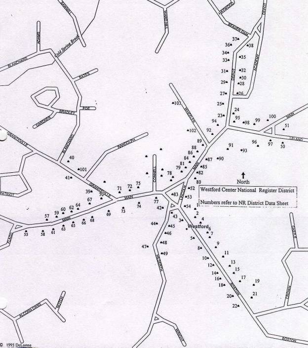
Westford Center Historic District
Graniteville Historic District
Description
Introduction
Graniteville is an industrial and residential village in the town of Westford, Massachusetts. According to Rev. Edwin R. Hodgman, author of the 1883 town history, “This village owes its existence to its water power and to the building of the railroad in 1847.” It is the location of the former C. G. Sargent & Sons machinery manufacturing company, a branch of the Boston and Maine Railroad and granite quarries from which the neighborhood derives its name. Architectural resources consist of poorly to well-preserved residential, institutional, commercial and industrial properties built during the Federal to Early Modern Periods. It is located in north-central Middlesex County along the banks of Stony Brook. Most buildings are residential but several commercial and industrial resources exist as well as a church, school and multiple unit residential construction. One hundred sixty-four historic buildings exist in the district. Two historic sites and four historic structures are also present. Architectural styles include Federal, Gothic Revival, Stick, Colonial Revival and Victorian Eclectic. Boundaries of the district are determined by changes in density of historic resources and by topographic changes.
The town of Westford is located in the coastal lowland region of the commonwealth, approximately 10 miles south of the New Hampshire border and 30 miles west of Boston. The town is bordered on the east by Chelmsford, on the south by Acton and Carlisle, on the west by Groton and Littleton and on the north by Tyngsborough. The area of the town is 31 square miles.
The village is set along the banks of Stony Brook and on the sloping hills to the north and south. Small residential and industrial lots are typical with some multiple-acre parcels on the west side of the brook where larger homes exist. Residential buildings are within 25 feet of streets except on the west side of the brook where larger homes have dramatic frontage overlooking the millpond. Industrial properties on Bridge Street are oriented more toward the railroad than the street. The densest portion of the district is the residential section comprising Broadway, Cross, School, Church, First, Second, Third and Fourth Streets. A school, church and small businesses such as grocery and hardware stores are located in this area as well. This density combined with industrial activity, rail traffic and the mill pond distinguishes the village from the remainder of the suburban town. It bears a similarity in scale, appearance and function to Forge Village, located a mile and a half to the southwest. The Graniteville Historic District retains integrity of design, feeling, association, materials and workmanship.
Development
Prior to 1847, Graniteville was a sparsely settled section of the primarily agricultural town of Westford. Land was in use primarily as farmland and small-scale industry until the construction of the Stony Brook Railroad in 1847, Mill #1 on North Main Street in 1858 (MHC #1) and Benjamin Palmer’s granite quarry in 1847 on Snake Meadow Hill.
Mr. Sargent arrived in Westford from Lowell in 1854 and began the manufacture of woolen mill machinery in an 18th century farmhouse and shop. The buildings burned in 1855, after which time he erected the existing stone mill building at the corner of Broadway and North Main Street in 1858. Construction of the mill confirmed Graniteville’s development as an important regional manufacturing and industrial village.
Mr. Palmer’s quarry was joined by several others in the north part of Westford, three of which were located on Snake Meadow Hill. Extraction of surface boulders from barren hilltops around 1820 led to the digging of quarries in exposed rock outcrops. Later, subsurface material was extracted and shipped on the Stony Brook Railroad. Mr. Palmer’s operation employed 20 men by 1882. Samuel Fletcher and William Reed arrived shortly after Mr. Palmer and began quarrying granite from adjacent parcels on Snake Meadow Hill. Evidence of the granite quarrying, which gave the village its name, remains in many places on Snake Meadow Hill.
Residences in the district were built in large numbers after 1865. They were the homes of industrial leaders and their employees, independent businessmen and other working class residents. The William Reed House at 67 North Main Street (#96, 1875) is a two and one-half-story Victorian Eclectic design with a profusion of ornament, including metal cresting at the roof ridge. The Charles G. Sargent House #1 on Broadway (#107, ca. 1830) is a Federal style residence that pre-dates the industrial aspects of the village but was the home of the principal industrialist and namesake for the local school. The Healy Oil Dealership at 5 Second Street (#97, ca. 1880) is an example of a small industrial operation serving the residents in the immediate neighborhood as well as those in other parts of town. Houses at 3 and 5 Fourth Street (#98, 99, ca. 1880) are small but ornamental Victorian Eclectic style residences that illustrate trends in upscale construction for mill employees in Graniteville.
Occupants of these distinct building types formed a cohesive neighborhood with a Gothic Revival style Methodist Church on Church Street, (#28, 1871) Stick style Sargent Elementary School on School Street (MHC #29, 1885), several small retail establishments and a community hall at 2 Cross Street (Now the American Legion). A recreational area, built by C. G. Sargent & Sons, with baseball fields and basketball courts is located at the southeast corner of the district off River Street. (ca. 1913)
Quarries
The former Samuel Fletcher Quarry (driveway at 49 North Main Street; ca. 1855) on Snake Meadow Hill continues in operation with some of the historic granite outcrops still visible. The site occupies approximately 45 acres. Most of the floor of the historic quarry has been overtaken by modern gravel manufacturing and rock crushing operations. Vertical outcrops of granite exposed during the nineteenth century remain in several spots on the hillside. These appear as granite walls with evidence of drilling and steel anchors for cables and lifting equipment. Anchors are located on elevated flat areas where derricks were placed for lifting blocks of stone.
The Benjamin Palmer Quarry (ca. 1855) is no longer in use but the outcrop remains a prominent part of the landscape of Snake Meadow Hill. The site occupies approximately 15 acres. Vertical walls of exposed granite on the north, east and west rise as much as fifty feet from the surface of the water. Blocks of unevenly piled stone are visible under the water. The elevated vantage points around the quarry provide views of a historic circulation path that curves from the open south side down into the quarry. There is also a toppled derrick that can be seen from points above the water. Metal fittings with attached cables are bolted to the tops of wooden poles that lie horizontally in the water. The poles would have stood in or near the center of the quarry floor. Metal anchors drilled into ledge remain on the elevated edges of the outcrop. Drill holes and other evidence of historic industrial processes survive around the edges of the flooded quarry.
The former William Reed Quarry is no longer in use and the floor is flooded. The site occupies approximately 1 acre. Vertical walls of granite surround the flooded quarry floor and rise approximately 20’ above the water.
The former David Reed Quarry on Snake Meadow Hill is significantly smaller than the other two quarries and is located farthest to the west. It is approximately 20’ across and only five feet deep. Blocks of stone remain at the site which is located adjacent to the east side of the crest of Cowdry Hill Road.
Industrial Architecture
The former Abbot Worsted Company Mill #1 (North Main Street, MHC #1, 1858) is a two-story granite ashlar building constructed on a long rectangular plan parallel to North main Street. The original roof is a shallow-pitched gabled form that has been raised by the addition of a more steeply pitched wood-framed gabled roof. One-story, flat-roofed additions have been made to the south side of the facade and to the southwest corner. The facade and principal entry are marked by a stone tower with a Mansard-roofed belfry and iron cresting at the peak. Originally, a square smokestack rose from the front of the mill. The current round smokestack was built of brick around 1880 on a square base rises at the south west corner of the building. The street elevation is lit by 21 double-hung sash placed close to the eave. Two doors are placed among the other openings on the facade.
The Sorting, Washing and Drying Building (ca. 1863) is located adjacent to the southeast wall of Mill #1. It is a two-story, shallow-pitched, gable-roofed form built perpendicular to the mill. The wood frame building is 12 bays long and three bays in width. The exterior is sheathed in vinyl clapboards and windows are modern replacement sash. The eaves of the shallow-pitched roof are articulated with brackets and a molded cornice. The primary entrance is form the northwest gabled end near Mill #1.
The Abbot Worsted Mill #1, the smokestack and tower are dominant architectural elements in the district. They are comparable only to the C. G. Sargent & Sons Machine Shop (MHC #27, 1877) on Broadway Street. Like the Abbot Mill on North Main Street, The Machine Shop is a granite ashlar building with a shallow-pitched roof and a tower rising from the facade. The three-story, nine-bay machine shop is the principal mass of a complex of buildings that includes granite and wood-framed additions and ells at the rear. Two one-story granite additions, also with the characteristic shallow-pitched roof, have been made to the west elevation of the shop. A two-story, wood-framed building is a separate structure but is attached to the rear (northeast) of the shop. This also shares the shallow-pitched roof form. The facade of the machine shop is articulated with a Mansard tower with a louvered belfry. A stone beltcourse, brackets, quoins and molded cornices further ornament the tower. Windows are primarily 12/12 double-hung sash with stone lintels and sills. Some 2/2 sash and openings covered in plywood exist on the facade. Doors to access the second floor and vehicle doors to the first floor are located on the east wall. A chain link fence separates the complex from Broadway Street.
The Abbot Worsted Company built two store houses for raw wool southwest of the intersection of River and North Main Streets by ca. 1875. The current gable-front buildings were constructed ca. 1940, possibly on previously existing foundations. Both resemble barns in form and materials. Exteriors are clad in vertical flushboard siding. Foundations are built of granite and roofs are clad in asphalt shingles. Large vehicle openings piece the gable ends. No ornament exists on the storehouses.
The Graniteville Foundry at 41 Bridge Street was a subsidiary of C. G. Sargent & Sons from the time of construction in 1917 until 1953 when the current owners bought it. The principal mass is a corrugated metal building constructed after a fire in 1965 to house foundry operations. This is a two-story, flat-roofed form oriented parallel to Bridge Street. Three metal storage tanks rise from the south elevation of the metal building. A one-story section with a large vehicle opening at the west side is clad in asphalt shingles and is part of the 1917 construction to survive the 1965 fire. A shed roofed, wood-framed garage (1917) is located adjacent to the street south of the foundry. It is clad in wood clapboards with an asphalt shingle roof. Six vehicle bays accessed by paired swinging doors pierce the south facing facade. A gable-roofed shop (1917), also built in 1917, with walls and roof clad in asphalt shingles is west of the garage. The shop is ornamented with gable returns and a molded cornice. Windows are 6/6 double-hung sash with beaded trim. The shed (1917) west of the foundry is a flat-roofed, 12-bay building constructed in 1917. The southerly four bays were added in the 1940s. The shed is clad in asphalt and asbestos shingles. Windows are boarded over double-hung sash. Other openings include rolling doors at the ground story and at the second story. The yard of the foundry is occupied by metal castings and slag piles in some places.
The 1965 cinderblock shop at 31 Bridge Street was the final location of the C. G. Sargent & Sons company operations in 1990 at the time they declared bankruptcy. The shop is a one-story, flat-roofed building of rectangular form with metal-framed sash in the side walls and vehicle openings on the south-facing facade. The shop is unornamented. A flat-roofed shed with open walls is attached to the northeast corner of the main building. The shed is built on an elevated concrete foundation. A sign says “SARGENT’S” near the roofline. East of the shop is the concrete foundation of a burned building. A metal water tank, cinderblock pump building, slag piles and piles of earthen fill and parking areas also occupy the parcel.
Institutional Architecture
The Methodist Episcopal Church (MHC #28, 1871) on Church Street is a Gothic Revival style design that represents the most ornate building in the village. It is a wood-framed, front-gabled form that faces the mill pond to the west and has a wooden tower with a tall slim spire at the northwest corner. A secondary tower and gabled entry porch are located at the southeast corner. The main vessel is enlarged at the sides by aisles which are reflected on the exterior by the shed-roofed expansions. The corner tower on the facade is supported at the corners of the base by buttresses that rise to become minarets. The principal entry is a double door which pierces the base of the tower below two Gothic arched windows and a Gothic arched louvered vent containing a carillon. Gables ornamented with crosses and quatrefoils on the four walls of the corner tower give rise to the narrow spire, which is clad in wood shingles. A large Gothic arched stained glass window and a small trefoil in the peak ornament the facade gable. Seven Gothic arched sash light the clerestory and aisle walls of the side elevations.
The Stick style Sargent Elementary School on School Street (#29, 1885) is an ornate building located immediately east of the Methodist Episcopal Church. The two-story rectangular form has a ridge-hipped roof marked at its center by a louvered ventilator flanked by two brick chimneys. The nine-bay facade is expanded by a two-story gabled entry porch with recessed entry and Stick style half-timbering in the peak. Hip-roofed entry porches of one story are located at the north and south ends of the facade. The facade is ornamented with additional half-timbering and string courses that divide the nine bays. Windows are modern double-hung sash with plain trim.
The rectory of Saint
Catherine’s Catholic Church at
107 North Main Street (MHC #93, 1927) is
a two and one-half-story, ridge-hipped Colonial Revival style design. It is a large rectangular residence with a
one-story, flat-roofed porch at the west side that is supported by Tuscan
columns. A single-story shed-roofed
entry porch is at the east side. The
two bays flanking the center entry project slightly and have hipped roofs ad exposed
rafter ends at the eave. Hipped dormers
occupy the front and side slopes of the roof.
The center entry is covered by a flat-roofed, one-story porch which is
supported by Tuscan columns and, like the side porch, has a full entablature
with dentils. The building is clad in
aluminum clapboards, the roof in asphalt shingles and the foundation is built
of cut granite. Colonial Revival
elements include the ridge-hipped roof, denticulated cornices on the porches
and the hipped dormers. Other ornament
includes the exposed rafter ends, sidelights and wide trim at the entry, and
molded window trim. Windows are
typically paired or grouped double-hung sash 4/1 and 8/1 pane arrangements. The projecting bays of the facade have both
sash types. Windows on the side walls
are 6/1 double-hung sash arranged either singly or in pairs. A single brick chimney is located at the
west side. This one of few Colonial Revival style houses in the district. A pyramidal hipped two-bay garage is located
behind the rectory.
Saint Catherine’s Roman Catholic Church (MHC #94, 1934) is a late Gothic Revival style design executed mainly in brick with cast stone trim. It is a three-bay front-gabled building of one and one-half-stories. The form is rectangular with an ell and a tower at the rear of the west side. A smaller ell is located at the rear of the east side. Gabled entry porches with Gothic arched doorways pierce both side walls. Three shed-roofed dormers occupy both slopes of the roof. The ell at the rear of the west side is a two-story mass with conical tower above. Buttresses of English derivation articulate the facade and side elevations. Walls are built of yellow brick with cast stone trim at the openings, buttresses and eaves. The roof is clad in wood shingles and the foundation is brick. Decorative elements include a Greek cross finial at the front gable peak, a Latin cross atop the tower, a cast stone beltcourse across the facade, and a wheel window and quatrefoil in the gable peak. Rosettes articulate ornamental panels near the wheel window. The principal entry is recessed behind trim composed of five concentric Gothic arches. An addition of two stories enlarges the plan at the northeast corner. Exterior materials are compatible with the historic building.
The former Graniteville Social Hall, located at 92 North Main Street (MHC #95) was built around 1925 in the Bungalow form. It is a single-story building of four bays width and a hipped roof. An enclosed hipped porch with matching dormer projects from the facade. Walls are clad in wood clapboards, the roof in asphalt shingles and the foundation is built of uncut granite. A side entry occupies the south side and is protected from the weather by a small hipped entry hood with carved brackets at the sides. Trim around windows and the entries is plain. Windows are 2/2 double-hung sash. A brick chimney rises from the rear of the hall. The building now functions as a residence.
The American Legion Hall Post #159 at 2 Cross Street is the former Abbot Worsted Social Hall, built around 1920. It is a Bungalow form building of one and one-half stories with hipped dormers on the front and side slopes of the hipped roof. Walls are clad in vinyl clapboards, the roof in asphalt shingles and the foundation is built of granite. Windows are modern single pane casement sash.
Residential Architecture
The Samuel Fletcher
House (MHC #31, ca. 1870) at 57
North Main Street is a three-story Victorian Eclectic style residence of
three by two bays. The side-gambrel roof
is articulated by a bell-curved slope below the upper slope and an octagonal
cupola. A wall gable above the
principal elevation shares the double-pitched roof form. A hipped one-story porch and central
second-story bay window further articulate the facade. A gambrel-roofed ell of one story and an
attached shed with the shallow pitched roof form typical of the district are at
the rear of the house that now serves as a funeral home. Walls are clad in wood clapboard, the roof
in asphalt shingles and the foundation is built of cut granite. Other ornament includes the bracketed eaves,
corner pilasters, single and double-arched window hoods, Palladian window in
the west side gable and corbelled chimney.
This house is larger than most others in the district and bears a strong
similarity in terms of its form and detail to the Charles G. Sargent House #2 at 25
North Main Street (MHC # 30, ca.
1870)
The Charles G. Sargent House #1 at 67 Broadway Street (#107, ca. 1830) is a Federal style house of two stories and a five-bay facade. The low hipped roof and its early date of construction distinguish it among other houses in the district. It is rectangular in form with a large one-story cinderblock addition at the rear. A brick chimney is located at each side of the roof ridge. The building is clad in wood clapboards, the roof is sheathed in asphalt shingles and the foundation is cut granite. The rear addition is founded on concrete. The main decorative feature is the Federal style center entry surround that features sidelights, a fanlight, a tall hood and pilasters. Windows are 2/2 double-hung sash. The flat-roofed rear addition functions as a warehouse. A chain link fence separates the house from the street. The Sargent house is in fair condition and has been altered with the addition of the cinderblock mass at the rear. The house was moved in ca. 1870 from its original site, which is now occupied by the C. G. Sargent House #2 on North Main Street.
The Charles G. Sargent House #2 at 25 North Main Street (MHC # 30, ca. 1870) is a three-story Victorian Eclectic style residence of three by two bays. The side-gambrel roof is articulated by a bell-curved slope below the upper slope and an octagonal cupola. A wall gable above the principal elevation shares the double-pitched roof form. Gabled dormers with round-headed sash flank the wall gable. A hipped one-story porch with an arcade that wraps around the west side and a central second-story bay window further articulate the facade. Walls are clad in asbestos shingles, the roof in asphalt shingles and the foundation is built of cut granite. Other ornament includes the single and double-arched window hoods, corbelled chimneys and corner pilasters. This house is larger than most others in the district and bears a strong similarity in terms of its form and detail to the Samuel Fletcher House at 57 North Main Street (MHC #31, ca. 1870).
The house at 17 Broadway (MHC #92, ca. 1885) is a one and one-half-story, two-bay, front-gabled residence of Victorian Eclectic design. A one and one-half-story ell with enclosed porch is attached to the south side. The walls are clad in wood clapboards, the roof in asphalt shingles and the foundation is built of uncut granite. Eaves are fitted with frieze boards, a molded cornice and short gable returns. Wide trim articulates the corners of the main block of the house. The entry is covered by an ornate flat-roofed hood with carved brackets, pendants and scroll designs at the sides. Windows in the principal mass have plain trim. Porch windows and those on the first story have been replaced with modern sash. A single brick chimney is at the north side of the main block. The wood-framed garage at the rear of the lot is a single-bay, single-story structure clad in wood clapboard.
The Victorian Eclectic style William Reed House at 67 North Main Street (MHC #96, ca. 1880) is an ornate two and one-half-story, deck-hipped form of three bays’ width. A two-story ell expands the plan at the rear and three gabled dormers mark the front slope of the roof. A central entry porch surmounted by a four-sided bay projects from the facade. A second bay window is at the first story of the west side elevation. Two brick chimneys are located within the main block of the house and a third rises from the rear ell. Walls are clad in wood clapboards, the roof in slate shingles and the foundation is built of cut granite. Windows are 2/2 double-hung sash except in some aspects of the bay windows which have narrow 1/1 sash. Dormers have peak headed sashes that are paired in the center example. Ornament consists of prominent window hoods, jigsawn brackets and piers supporting the center porch, eave brackets, corner pilasters and metal cresting at the deck hipped portion of the roof. Another dramatic element of the design of the house is the setting, which overlooks the Stony Brook Railroad grade and Stony Brook itself. The village of Graniteville is visible to the northeast. The setting of this house sets it apart from others in the district.
The Victorian Eclectic style C. G. Sargent & Sons Employee House at 3 Fourth Street (#98, ca. 1880) is a one and one-half-story, front-gabled, two-bay house with porches at the south side and the rear. The rear addition is a one-story, flat-roofed porch with fixed sash along the west wall. The south side porch is a one-story enclosed form with a low-pitched hipped roof. The facade is covered by a third porch with an integrated bay window. The walls are clad in wood clapboards, the roof in asphalt shingles and the foundation is built of uncut stone. Ornament includes paired brackets at the eaves, molded cornice, frieze, corner quoins, and molded window trim. This and its neighbor to the north are highly ornate examples of worker housing in Graniteville.
The Victorian Eclectic style C. G. Sargent & Sons Employee House at 5 Fourth Street (#99, ca. 1880) is a one and one-half-story, front-gabled, two-bay house with porches at the north side and the rear. The rear addition is a one-story, flat-roofed porch with fixed sash along the west wall. The north side porch is one-story with a low hipped roof enclosed in sliding glass doors. The facade is covered by a third porch with an integrated bay window. The walls are clad in wood clapboards, the roof in asphalt shingles and the foundation is built of uncut stone. Ornament includes paired brackets at the eaves, molded cornice, frieze, corner quoins, and molded window trim. This and its neighbor to the south are highly ornate examples of worker housing in Graniteville.
The house at 6 Fourth Street (MHC #100, ca. 1916) is a two and one-half-story, four-bay, Colonial Revival style building with a ridge-hipped roof. The form is rectangular with a two-story porch at the facade. A one-story, three-sided bay window expands the plan at the west wall and a hipped dormer occupies the front slope of the roof. The house is clad in wood clapboards on the first story and wood shingles on the second. The roof is sheathed in asphalt shingles and the foundation is built of random ashlar. The porch occupies the full width of the first story and half the second. Both are supported by grouped colonettes and a knee wall. Both are articulated with molded cornices. The house is ornamented with deep eaves with frieze board, varied exterior wall cladding and molded cornice. Windows are 2/1 double-hung sash with molded trim. A brick chimney rises from the center of the roof. This is a rare large Colonial Revival style design in Graniteville.
The multiple residence at 8-20 Fourth Street (MHC #101, ca. 1916) is a two and one-half-story, five-bay plan characterized by the three wall gables and four shed dormers on the principal elevation. Three hipped entry porches further animate the facade. Walls are clad in vinyl clapboards, the roof is asphalt shingles and the foundation is built of random ashlar. Ornament consists mainly of the molded cornice, and Doric columns supporting the entry porches. Windows are 6/6 except where replacements have been installed. The house is distinguished by its size and large number (7) of dwelling units.
The multiple unit residence at 66 Broadway (MHC #106, ca. 1875) is a two and one-half-story, side-gabled form that houses five dwelling units. Two gabled dormers occupy both slopes of the roof and a full-width hipped porch covers the first story of the facade. A secondary hooded entry is at the center of the south elevation. Siding is wood clapboard, roofing is asphalt shingle and the foundation is built of cut granite. Windows are 2/2 double-hung sash. The center entry has wide but plain trim. Two brick chimneys occupy the center of the ridge of the roof. Trim around windows, eaves and at the corners is plain. The porch is articulated with Colonial Revival elements such as the Doric columns and molded cornice.
At least five residential examples of a two by two-bay, two-story form with a distinctive shallow-pitched, side-gabled roof exist in the district. These are double-houses located at 10-12, 41-43, 48-50, 56-58 Broadway and 3-5 Cross Street, all built around 1870. Paired center entries are located under the hipped full width porch. Paired brick chimneys mark the nearly flat roofline. Very little ornament is present on these houses and most have been re-sided with vinyl clapboards. The most intact example is at 3-5 Cross Street which retains its corner pilasters, frieze board and wood clapboard exterior. Variations on the form consist of a gabled porch covering the center bay at 3-5 Cross Street and one example with four bays across the facade instead of two at 56-58 Broadway. The shallow pitched form exists on some non-residential buildings. The hardware store at 37 Broadway, the shed at 57 North Main Street, ancillary mill buildings at both the Abbot Worsted and C. G. Sargent & Sons mills all display the characteristic roof form.
Other examples of typical worker housing architecture in Graniteville are represented in designs at 40-42 and 44-46 Broadway, built in ca. 1870. These two-story side-gabled, five by two-bay buildings are enlarged by full width dormers on the front and rear slopes of the roof. Two chimneys reflect the divided uses of the interior. The duplexes are clad in vinyl clapboards with asphalt shingle roofs and granite foundations.
Commercial Architecture
Parent’s Market at 27 Broadway (#91, ca. 1870) is a two-story commercial building with a false front atop the facade of the principal mass. A one-story ell at the east side was added in the mid 20th century. An aluminum store-front covers the entire width of the first story and is canted at the east corner entry. The main block was built in ca. 1875 on a two-bay plan. It was originally clad in wood clapboards that are still visible on side elevations. Brackets and a molded cornice ornament the false front. Second story windows are 2/2 double-hung sash with plain trim. A second story porch provides access to upstairs living space.
J. A. Healy & Sons Oil Dealership at 5 Second Street (#97, ca 1880) is an unornamented industrial building. The low-pitched roof, three bay facade and large vehicle doors lend it a utilitarian aspect. The exterior is clad in vinyl clapboards and the foundation is built of concrete. Windows are modern double-hung sash with plain trim except the left (south) side of the first story which has modern casement sash. A door to the second story with a rolling track above for lifting freight pierce the center of the facade.
The former Furbush Garage (MHC #102, ca. 1910) and gas station at 1 Broadway Street is a one-story light industrial/commercial building built of cinderblock. The eastern side of the facade consists of rock faced block while the west is plain. The facade has a false front with two stepped gables. The west half of the five-bay facade comprises the principal gable and was added to the original building. The main opening is a roll-up door in the west side. A second vehicle door now partly filled in, occupies the center of the facade and two display windows further light the interior. A pass door gives access between the second vehicle door and display window. All openings have concrete lintels. This is one of several former small retail and light industrial businesses in Graniteville. It served as a Chevrolet dealership until ca. 1930.
The former West Graniteville Station of the Nashua and Acton Railroad at 98 North Main Street (MHC #105, ca. 1873) is a two-story, side-gabled building that has been adapted for residential use. A full-width hipped porch of one story expands the facade. The building is clad in wood clapboard, the roof in asphalt shingles and the foundation is built of cut granite. Ornament consists of the short gable returns, corner boards and a molded cornice. Windows are 2/2 double-hung sash with plain trim. The brick chimney rises from the north slope of the roof.
Bridges
The bridge carrying Conrail over Stony Brook and Bridge Street is the only historic bridge in the district. Two plate girder spans cross the stream and the road. Abutments are variously built of concrete, granite ashlar and granite combined with concrete. A causeway for vehicle traffic on Bridge Street is built of uncut granite and concrete. The causeway crosses the stream while passing under the railroad bridge.
Broadway Street crosses Stony Brook at North Main Street on a reinforced concrete bridge constructed in 1988. This replaced an earlier bridge with a wooden deck. The cut granite abutments were built at the time of the 1855 fire that destroyed the mill and the former wooden dam. The raceway is integrated into the abutments and survives beneath the modern bridge.
The River Street Bridge over Stony Brook is a reinforced concrete structure constructed in 1997. The River Street Bridge over the Conrail tracks is a reinforced concrete structure built in 1998.
Pond
The Mill Pond between North Main, Broadway and Bridge Streets was created in 1858 when C. G. Sargent and his business partner Francis Calvert rebuilt their burned Mill #1 and the accompanying dam. The pond was enlarged with the construction of Mill #2 in 1877. Its outflow runs between the mill buildings and was used for water power until the late 19th century. It is approximately 10 acres and constitutes an integral component of the village. It occupies what amounts to the front yard of the Methodist Church and is immediately visible for a half mile along North Main Street.
Statement of Significance
Summary
The Graniteville Historic District is eligible for the National Register of Historic Places under criterion A for its associations with patterns of 19th century industrial village planning practice and for manifestations of 19th century quarrying activities. It is eligible under criterion C for its embodiment of the distinctive characteristics of its nineteenth century architectural resources. The district retains integrity of design, craftsmanship, setting, feeling and association. The period of significance for the district is 1848-1949, which corresponds to the construction of the Stony Brook Railroad and to the close of the Early Modern Period of history. There are approximately 200 contributing buildings, sites, structures and objects in the district.
The neighborhood of Graniteville survives as a well-preserved example of a cohesive nineteenth century industrial village. The historical associations are generated by the survival of many 19th century workers’, the clear representation of nineteenth century planning involving narrow streets, pedestrian-scaled house lots and a similarity of building form, scale, material and siting. Placement of buildings in relation to the street and the density of their construction combine to create a village sensibility representative of the district’s historical patterns of development. Increasing amounts of new construction threaten to dilute the nature of the historic district.
Contact Period 1500-1620
Algonquin-speaking Wamesit, Pawtucket and Nashoba tribes of Native Americans inhabited the area between the Concord and Merrimack Rivers. Habitation of Westford was concentrated near wetlands such as those along Stony Brook. Projectile points have been recovered in these areas and in upland sites, which indicates scattered hunting activity throughout the town. None of the three suspected Native settlements in the town were determined to be in Graniteville although it is possible that tribe members exploited the hunting and fishing opportunities in the area. Fishing on Stony Brook during the Contact Period is indicated by the existence of a fish weir that was recorded at the outflow of Forge Pond in the mid 17th century. This is on Stony Brook one and one-half miles west of the district. Travel by Native Americans through the area is conjectured to have been along Stony Brook, possibly the current alignment of North Main Street.
Colonial Period 1620-1775
Travel by White settlers between Chelmsford and Groton began in the mid 17th century on the road that paralleled Stony Brook on the south side (now Forge Village Road, Pine Street, Cold Spring Road) which connected West Chelmsford to Forge Village and Groton. At this time, Westford was part of Chelmsford and residents of that town were responsible for improving the transportation network. In 1655, the town of Groton resolved to build a road leading east to Forge Pond that would connect with roads to West Chelmsford. In Graniteville, Pine Street, Forge Village Road and Cold Spring Road, all south of Stony Brook, were the closest streets to the village. Westford was a hinterland at this time and was viewed as little more than a geographical barrier between established villages. Settlement was sparse in the town and in the district. No buildings from the period remain.
Federal/Pre-Industrial Period 1775-1854
Late 18th century travel continued on the south banks of the Stony Brook and on a newly developed route north of the stream. The road that became North Main Street was in place at least as a path by 1780-1790 according to the 19th century town historian, Rev. Edwin R. Hodgman, and to property deeds that describe residences along the brook’s north bank. There is no evidence that River Street or other roads in Graniteville had been built by this time. Population in the district in the late 18th century was no more than 30 although the industrial development of this part of the Stony Brook Valley had begun.
Grist and saw mills associated with at least two residences were in operation on the north bank of Stony Brook by the 1780s. Hodgman (p. 355) states that in 1783 Thomas Cummings owned a house and grist mill below (downstream of) the current C. G. Sargent & Sons mill, near what is now Brookside Road. Residents named Timothy and Isaiah Prescott lived near the site of the Sargent mill and operated a saw and grist mill in 1798 upstream of the current mill. It is probable that the Prescotts were engaged in subsistence farming as well as milling given their relatively large tract of land. The 1798 property deed describes the Prescott mill as a house with a grist, corn and saw mill and mill yard set on 65 acres of land. Stream water was retained by a dam with wooden flash boards.
The path along Stony Brook was clearly represented as a road
by the time of the 1831 Hales map of the town.
Deacon John Prescott, the subsequent owner of the Isaiah and Timothy
Prescott’s mill, is shown along with three other unnamed buildings in the
district. Deacon Prescott was a
descendant of the family who were involved since the 18th century in
manufacturing iron in Forge Village at the outlet of Forge Pond. There is no mill pond depicted on the 1831
map, indicating the milling operation had not yet developed to current
levels. River Street exists on the map
and connects to the current Graniteville Road to Westford Center. Deacon Prescott sold the mill to Thomas
Richardson in 1835 who then sold to the machinist Asahel Davis. Mr. Davis sold the mill and farmhouse to
Francis Calvert and C. G. Sargent in 1854 who had formed a partnership in
Lowell to manufacture wool processing machinery.
The Stony Brook Railroad was built through the village in 1847 as a means of connecting railroads located in the manufacturing centers of Groton Junction (Ayer) and Lowell. Graniteville was one of four station stops in Westford. Other industrial development in the form of mills and a blacksmith shop had occurred at the other Stony Brook Railroad stops in Forge Village, Westford Station at Depot Road and at Brookside on the present Brookside Road. Completion of the railroad was doubtless a factor in the decision by Calvert and Sargent to move here from Lowell and in the profitability of the several granite quarries in the town.
Early Industrial Period 1854-1877
Transportation
The Nashua and Acton
Railroad was constructed through West Graniteville in 1872-73 and offered
connections to the towns of its name as well as Concord, Massachusetts. This railroad crossed over the Stony Brook
at a point south of the intersection of West Street and North Main Street. The area around this intersection became the
site of one of the district’s granite yards.
Population
The number of residents in the village was increasing with incoming machine shop, railroad and quarry employees. At the time of Mr. Sargent’s arrival in the village, Hodgman states that there two or three houses in the area. Drake stated in 1880 in his county history that, “When he [Sargent] came there in 1854, there were only five or six houses, and only a saw and grist mill upon the stream.” Graniteville had become a separate school district in 1851, according to the historian Hamilton Hurd. In 1875 there “were eighty-nine families and these have since increased to a hundred at least” by 1890. The 1855 Symmes map of Westford depicts increased residential construction on North Main Street sufficient to warrant a post office and store at the corner of Pine Ridge Road. Bridge Street was laid out and constructed off Pine Ridge road between 1857 and 1874. A cluster of homes north of the village is labeled “Irish Shanties”, presumably an ethnic enclave housing employees of the nearby granite quarry and mills. A second ethnic group clustered on North Main Street in what was called West Graniteville or “Swedeville”. The area from approximately 70-100 North Main Street was occupied by a dense population of Swedish quarry workers. By 1865, approximately 160 people lived here, 20% of whom were from the United Kingdom. Perhaps 120 of the 160 residents were employed at either C. G. Sargent & Sons or Abbot Worsted’s factories. Fifty-six employees were women. One family of African Americans was located in the vicinity according to the 1865 state census. 1870 federal censuses show 360 people in the village, which was enumerated separately from other villages and rural sections of town. The number of foreign-born residents increased as more Irish, Scottish and English arrived to work in the machine shop, woolen mills and quarries.
Economic Base
Quarrying
Early activity in Westford’s granite quarrying industry involved removing surface boulders with oxen and wagon for building purposes. Columns of the Quincy Market building in Boston were constructed in 1822 from Westford granite transported in this way. Boulders, and then subsurface material were later extracted from quarries located on Snake Meadow Hill, Oak Hill and other unnamed areas in the north part of the town.
In Graniteville, Snake Meadow Hill offered the best quarrying opportunities. By 1855, at least four outcrops were being worked. The largest quarry was owned and operated by Benjamin Palmer who arrived in Graniteville and began removing stone in 1847. At that time, just before the completion of the Stony Brook Railroad, he hauled his product by wagon into the growing city of Lowell. Very Shortly after the arrival of the railroad, Mr. Palmer had a rail siding built to his quarry as a way of facilitating shipment. William and David Reed and Samuel Fletcher were in the quarry business on Snake Meadow and Cowdry Hills by 1855. Other quarries of smaller size existed inside and outside the district into the 20th century.
During the period, the quarrying process involved the use of explosives in conjunction with steam-powered drills to loosen the material. Derricks, or pulleys mounted on moveable poles, facilitated lifting and removing the blocks of stone from the pit. Horses, mules and oxen were employed in pulling lines to lift the stone onto wagons or directly onto railroad cars. Local historians indicate the material was used in construction of the dam across the Merrimack River in Lawrence, Massachusetts, the State Prison in Concord (1870-1880’s), plus various construction projects needing stone lintels and sills, foundations, curbstones, paving stones and bridge abutments. Other destinations for granite shipments were Chicago, New Orleans and New York. The total number employed in Graniteville’s quarries was approximately 15 men in 1865. By 1870, there were around 21 quarry employees according to the federal census of that year.
C. G. Sargent & Sons Machine Manufacturers
While the district was named for the stone extracted from its quarries, the principal influence on the appearance of the area derived from the machine manufacturing concerns located there. C. G. Sargent’s companies manufactured woolen machinery and associated goods with a labor force numbering in the hundreds. The factory buildings, rows of employee houses and various support businesses such as stores and shops contributed most to the development and current historic appearance of Graniteville.
Calvert & Sargent, as the machine manufacturing firm was first known, bought the former Prescott Mill on Stony Brook in 1854 from then owner Asahel Davis. Mr. Davis was a machinist from Harvard who owned the saw and grist mills, mill yard, water privileges and 65 acres (according to the deed of transfer to Sargent) from ca. 1840-54. The complex burned one year after Calvert & Sargent acquired it. While continuing operations in Lowell, they replaced the wooden, semi-residential/industrial complex with the existing stone Mill #1 at the corner of Broadway and North Main Streets in 1858, 1/8 mile downstream (Mill Building #1; MHC # 1, 1858). Mr. Sargent recorded in a ledger entitled “Grist Mill Book” the price of grain for 1868-69 indicating the grist mill component of the former Davis operation may have escaped destruction by fire and remained in use. Calvert and Sargent focused on making machines, primarily of Sargent’s design, for cleaning, drying and washing wool. Original dimensions of the stone building were 185’ x 52’ with a 32’ x 40’ ell. Additional buildings were constructed in 1863 and 1864 for scouring and drying wool. This may refer to the Sorting, Washing and Drying Building south of Mill #1. By 1865, industrial statistics of the commonwealth indicate the C. G. Sargent & Sons employed 40 hands
In 1859-60, Calvert & Sargent did business with Amesbury Mills, Lowell Machine Shop where Mr. Sargent began work in the trade, Lawrence Machine Shop, Nashua (New Hampshire) Iron Foundry, Seneca Falls (New York) Knitting Company and Appleton Mills in Lowell, Massachusetts. Perhaps their most important customer was the Abbot Worsted Company who rented their Graniteville factory and bought their machinery from C. G. Sargent. In 1863, Mr. Calvert allowed himself to be bought out of the company’s operations, giving Mr. Sargent sole ownership of the machine shop. The company was renamed C. G. Sargent Sons.
Charles Grandison Sargent 1819-1878
Charles Sargent was a native of Hillsborough New Hampshire who demonstrated an early aptitude for machinery repair and design. In his teen years he was apprenticed to a clock maker and later worked at the Lowell Machine Shop, becoming a master of the machining trade. Mr. Sargent had taken a license to manufacture a patented cotton gin in 1840 when he was 21 years old. He invented the “New England Comber” in 1842, and in 1847, a burring machine used to remove impurities from wool or cotton before spinning. Other inventions followed for drying, oiling and carding wool and cotton. His involvement in several industrial concerns in Graniteville from 1854 until his death in 1878 remade the village from a hamlet to an ethnically diverse, economically stable village that was the primary seat of industry in the town during his lifetime. Part of Mr. Sargent’s method of developing Graniteville into a residential village was to buy land around his mill for construction of worker houses. Property deeds from the 1860s and 1870s reflect land purchases at the eastern foot of Snake Meadow Hill and along the east banks of Stony Brook. Rentals in 1869 for his 4 employee houses, probably on Broadway Street, cost $6.25 per month according to ledgers from the period.
Mr. Sargent invented, refined and manufactured wool and cotton sorting, washing and drying equipment under the company name Charles G. Sargent & Sons in his 1858 Mill #1 (MHC #1). In 1858, Mr. Sargent entered into a partnership with J. W. P. Abbot and his son John W. Abbot, local businessmen, to use Sargent machines in the manufacture of worsted yarns for carpets and for decorating furniture. For this purpose, the mill building was expanded with an addition that doubled the original space. Mr. Sargent departed the company in 1859 to focus solely on his machinery manufacturing firm for the next four years. Allan Cameron, a wholesale textile buyer, salesman, worsted carpet manufacturer and bookkeeper was brought in as partner in the worsted branch of the business. Mr. Sargent returned to the Abbot partnership in 1863 and continued to work at both industries until his death in 1878.
Abbot Worsted Company
The Abbot Worsted Company was begun by local residents John W. P. Abbot and his son John W. Abbot who acted as treasurer. The Abbots later hired Allan Cameron as sales agent and bookkeeper. The company began manufacturing carpet yarns at Calvert and Sargent’s Mill #1 in 1858. An addition was made to the mill in 1859 to accommodate increased volume of production. In 1859, Calvert & Sargent negotiated with Abbots to build and lease a separate 100’ x 50’ building for a hosiery and woolen mill. The Abbot Worsted Company called for a building fitted out with propellers and shafts and “water power equal to 40 horse”. This may have been the building described in an 1872 insurance policy as being built of wood, two stories in height with fixed machinery for burring, carding and spinning wool. (The Abbot Worsted Company machinery was bought from C. G. Sargent & Sons, manufactured in Mill #1) By 1865, industrial statistics of the commonwealth indicate the Abbot Worsted Company employed 80 hands. The Abbot Worsted Company built an office at the corner of Broadway Street and North Main Street in 1866. The two-story, wood-framed building, depicted in historic photos, faced North Main Street and served as company offices until the 1950s. The foundation remains visible. In 1877, the Sargent company built a new machine shop on Broadway Street which left the Abbot Worsted Company as the sole occupant of Mill #1.
Three store houses for raw wool are located southwest of the intersection of River Street and North Main Street. The original store houses were built in around 1875 and, like the current buildings, are similar in form to gable-roofed barns. Abbot agents bought raw, unwashed wool which was kept in the store houses. Prior to weaving, the product was removed from the store house to an elevator at the northwest end of the gabled, wood-framed Sorting, Washing and Drying Building located adjacent to the southeast wall of Mill #1. The wool was then brought to the top floor where it was sorted by grade of quality and then moved downstairs for washing and drying. Machines to do this work were designed and built by C. G. Sargent & Sons. Dried wool was taken from the Sorting, Washing and Drying Building to Mill #1 for carding, combing and spinning. After being wound into skeins, it was either shipped to the point of sale or sold from the office under the bell tower in Mill #1.
Abbot Worsted owned 12 buildings for housing employees in 1875. These were located mainly on the west side of Broadway Street. Examples are the double houses at 44-46 and 48-50 Broadway Street, built ca. 1870.
Pre 1877 Architecture
Institutional
Mr. Sargent’s involvement in the community was sufficiently deep that he donated land and a large part of the $10,786.13 construction cost for the 1871 Methodist Episcopal Church on Church Street. He left an additional $1000 in his will to the congregation. This building is the most architecturally significant resource in the district. The church was constructed by Mead, Mason & Co. according to plans drawn by architect Shepard S. Woodcock, a Somerville architect who designed Queen Anne style houses and public buildings in Boston, Cambridge, Lowell and elsewhere. It occupies a key location in the village that overlooks the Mill Pond. The site is similar to Sargent’s own house which overlooks the pond from the opposite direction. A photo of the church appeared in a November, 1982 article in Smithsonian Magazine profiling American Churches and Gothic Revival design.
Residential
During the 1870s, Charles Sargent, William Reed, Benjamin Palmer, Samuel Fletcher and their families built houses on the south slope of Snake Meadow Hill overlooking the Mill Pond, the Methodist Church and Sargent’s mills. This row of high style Victorian Eclectic houses command the most important site in the district. The front yards rise from the edge of North Main Street with a tall granite block retaining wall at its edge. Mr. Sargent built his side-gabled Mansard-roofed house at 25 North Main Street with a profusion of ornament in ca. 1870 (MHC #30). Local tradition states Mr. Sargent admired the Fletcher House at 57 North Main Street and hired the same contractor for his own. Construction took 7 ½ years due to the intricacy of the design which includes an ornate window imported from Italy in the back wall. The house was subsequently occupied by Mr. Sargent’s son Frederick and family members Harriet Sargent Hildreth and Mary Sargent. Samuel Fletcher had his house at 57 North Main Street (MHC #31) constructed in ca. 1870. William Reed built his Mansard roofed mansion in ca. 1875 at 67 North Main Street (MHC #96).
Other examples of residential construction were carried out in the Victorian Eclectic, Gothic Revival, Colonial Revival, Federal, Victorian Eclectic and Craftsman styles. Mr. Sargent contracted with local builders William, C. Edwards, W. G. Howe and J. A. Healy, among others, to build at least 9 houses by the time of his death in 1878. Approximately nine Sargent company employee houses are represented on the 1875 Beers atlas of the village, many of which are duplexes.
Commercial
The Abbot Worsted Company had an office built in 1866 west of Mill #1 on North Main Street. The two-story, building with shallow-pitched gabled roof appears labeled as “Office” in historic photographs. It is described in archives as having a foundation built of granite supplied by William Reed’s quarry. The shallow-pitched gabled form is repeated in other construction throughout the district. The buildings have a nearly flat roof that appears at least five times for multiple-unit residences on Broadway Street (#s 10-21, 37, 41-43, 48-50, 56-58) and in other buildings that appear in historic photos but do not survive. The office was demolished in the 1950s.
Industrial Period 1877-1910
The mid 1870s was a prosperous time for industry in Graniteville. Quarries and both the Abbot Worsted Company and C. G. Sargent & Sons flourished. The Abbot Worsted Company purchased and occupied in ca. 1878 the former horse nail factory in Forge Village which became their principal manufacturing facility by 1910 (MHC #38). C. G. Sargent & Sons constructed a new stone mill building in 1877 (Sargent Mill #2, MHC #27) on the site of the demolished wood-framed Mill #2, across Stony Brook from Mill #1 (MHC #1, 1858). Employee housing was built on newly laid out Third and Fourth Streets and on River Street.
Transportation
The Stony Brook Street Railway operated through the village starting in 1907. The route entered Graniteville from the east on Beacon Street and traversed North Main Street toward Forge Village. Streetcars connected Graniteville, Forge Village and Westford Center to Ayer in the west and Chelmsford in the east. The railway remained in operation until 1921.
Population
Residents of the district evolved during the mid-late 19th century from a mainly native-born group to one of significant foreign-born population. In the 1865 state census, approximately 20% of the residents were foreign-born. By the end of the century the percentage of foreign-born residents would be more than half. These groups of immigrants brought with them new religions, such as Catholicism, and activities such as foreign language classes at the community hall. In 1904, immigrants were from Sweden, Finland, Canada and Italy. By 1907, Russians begin to appear on lists of residents and in marriage records. Around 1910, agents of the Abbot Worsted Company traveled to Russia in order to recruit laborers. The results of their efforts are evident in increasing numbers of Russian surnames in subsequent census schedules.
The number of Graniteville residents grew to 360 in 1870, outnumbering Forge Village by 120 residents. By 1880, 73 woolen mill employees in Graniteville outnumbered machinists and quarrymen by 2-1. There were in 1880 numerous children between 10 and 15 years of age working in the woolen mill and not attending school. At this time, laborers in the quarries and mills were as likely to be Massachusetts-born as they were to be foreign-born. The village had 200 mill employees in 1890, according to county historian Hamilton Hurd. This number increased to a total of around 250 by 1910.
Catholic residents became sufficiently numerous in the 1870s that visiting pastors from Saint Patrick’s Catholic Church in Lowell led services in homes of individuals. In 1892, Westford’s Catholic population built a wood church on North Main Street between Graniteville and Forge Village, the locations of the town’s densest Catholic populations.
Americanization and education was among the list of priorities for the immigrants, the employers and the town government. Toward this end, the school department operated a night-school program for factory employees beginning in 1892. This program continued well into the 20th century in what were known as the Abbot Company Halls, three of which existed in Graniteville, Forge Village and later at Brookside in the eastern part of town (1 mile downstream on Stony Brook.).
Growth in the village was sufficient by 1909 for the establishment of a fire department. Graniteville’s Sargent School was the town’s largest in 1909 with four classes. This was more than schools in Forge Village and Westford Center, which had three classes. Other districts had a single class.
Economic Base
Industrial Establishments
The years from 1877 to 1910 saw increasing levels of company productivity in the village. C. G. Sargent & Sons built a second factory building of stone in 1877, among many other secondary buildings. This 1877 Mill #2 combined with the 1858 Mill #1 represent the economic motive force of the district and fostered development of nearly the entire neighborhood from Broadway west to River Street, south to Bridge Street and northwest on North Main Street to West Street. The Abbot Worsted Company expanded their operations into nearby Forge Village; the Palmer, Reed and Fletcher quarries flourished with the construction of the north-south rail link provided by the Nashua and Acton Railroad. As a result of the ongoing economic health of the corporate community, the village of Graniteville experienced new construction of homes and residential streets, a new school that was much larger than what had been in use previously and increased variety of ethnic and cultural groups recruited by company officials to perform work in the factories.
Charles Grandison Sargent oversaw the design and construction of his new Mill #2 (MHC #27) and dam at Broadway Street in 1877. LeRoy Cherrington was the architect of the “Machine Shop Building” and stated in his specifications that the building should have a tower with name tablet, belfry with louvered panels, corner quoins and iron cresting, all significant elements still visible from the street. This building became the principal machine manufacturing and erecting facility where C. G. Sargent & Sons’ products were assembled until ca. 1970. This was one of the final acts of Mr. Sargent in regard to his machine company. He died at his summer residence in Salem, Massachusetts in July, 1878. The architect of Mill #2 was a member of a firm named Cherrington and Cherrington, based in Lowell. They were responsible for the design of the 1875 Gorham Street Firehouse (MHC Lowell # 475).
While Mr. Sargent was the creative influence behind the work done at the factory, his sons Francis and Charles G. Sargent Jr. renamed the company C. G. Sargent’s Sons and carried on the business with a great deal of success into the 20th century. Francis Sargent was credited with several patents for new machines and refinements of older designs between 1880 and 1910, indicating that he had inherited his father’s industrial creative abilities.
C. G. Sargent’s Sons grew during the period from an employer of approximately 20 machinists in 1877 to 75 in 1906. Other employees not considered machinists may also have been employed. By 1878, the company was shipping machinery to California, and by 1908, they had clients in Germany. The company was incorporated as C. G. Sargent’s Sons in 1904.
In 1877, The Sargents renewed the lease for Mill #1 to John W. Abbot, Abiel J. Abbot and Allan Cameron, proprietors of the Abbot Worsted Company. John Abbot acted as treasurer, Allan Cameron was the agent or salesman and buyer for the company. This corporate structure endured into the early 20th century. John W. P. Abbot, an original investor and father of John W. Abbot, died in 1872. By 1908, the president of the company was Allan Cameron’s son Julian, Abiel Abbot was treasurer and Julian Abbot was agent. Abbot, Cameron and Sargent family members would retain interest in both the Sargent and Abbot companies through the 1950s.
Abbot Worsted incorporated in 1900 and grew during the period from an employer of approximately 200 in 1877 to 500 in 1908. Half of these employees worked in Graniteville and half in Forge Village.
Chauncy Mills was a subsidiary of the Sargent mills engaged in making socks. Miner H. A. Evans (also the former pastor of Graniteville Methodist Church) was proprietor of the company from ca. 1878-1883 which employed 30 people in 1883. The company used prison labor in 1878 to sew socks. This may have been the former C. G. Sargent’s Sons hosiery mill which was adjacent to Mill #2 on Broadway Street.
Quarrying on Snake Meadow Hill at the end of the 19th century was a growth industry. The 1889 Middlesex County Atlas lists Samuel Fletcher, Benjamin Palmer, David Reed and William Reed as granite quarry proprietors. Four quarries were in operation in the village in 1906 according to newspaper accounts from that time.
Commercial Establishments
John A. Healy operated a company that performed excavation, landscaping and related tasks as well as an oil dealership in the building at 5 Second Street (# 97, ca. 1880). This company dug trenches for the town water system, excavated foundation holes and landscaped yards for company housing in the village. The 1889 county atlas indicates a store was operated by residents named Wright & Bemis on North Main Street near Bridge Street, a blacksmithy run by David Reed near the Catholic Church in West Graniteville and A. S. Stoddard had a store on Second Street.
Commercial establishments in Graniteville in 1906 according to newspaper accounts included three grocers, three variety stores, one fruit and one cheese store, a milliner, a blacksmith, a provision store and several peddlers and dressmakers supported by the village population of 500.
There was very little farming in the village during the period.
Architecture
Industrial
As part of its ongoing expansion, C. G. Sargent & Sons built the Mill #2, or Machine Shop Building at the crossing of Stony Brook and Broadway. (C. G. Sargent Mill #2, # 27, 1877) The “New Mill” was to be 50’ x 100’ with a 76’ high smokestack and a 68’ high tower. Specifications also identify the boiler house which indicates the use of steam power instead of water power. Other buildings in existence at the time include a one-story stocking mill and a separate blacksmith shop.
Institutional
The Sargent Elementary School was built in 1885 (MHC #29, 1885) by builder William C. Edwards on land bought by the town from C. G. Sargent. Between 1885 and 1910, the Sargent Elementary School housed more classes than both Forge Village and Westford Center, indicating the population growth in the village.
Catholic residents became sufficiently numerous in the 1870s that visiting pastors from Saint Patrick’s Catholic Church in Lowell led services in homes of individuals. In 1892, Westford’s Catholic population built a wood church on North Main Street between Graniteville and Forge Village, the locations of the town’s densest Catholic populations. The wood framed building remained in use until 1934.
Residential
Beacon and Maple Streets were laid out and developed with workers’ residences between 1875 and 1889. Some of these were owned by the Abbot Worsted Company, but others were owned by a private landlord named John Grieg who worked for the Abbot Worsted Company as a superintendent. Mr. Grieg owned four Victorian Eclectic style houses at 6, 8, 10 and 12 Maple Street (1880-1890).
By 1889, C. G. Sargent & Sons had at least 15 dwellings for housing employees and the Abbot Worsted Company had 11. These company houses set the precedent for the current high level of density of construction in the village. Much of Broadway Street and others had not been developed by this time, leaving room for future construction. Church Street had been laid out and partially developed, as had First, Second and Cross Streets, but not Third and Fourth.
Modern Period 1910-1949
Transportation
The Stony Brook Street Railway failed in its battle to compete with the automobile and went out of business in 1921. Tracks for the railway were removed from North Main and Beacon Streets in 1930.
Population
1910 federal census figures show that a dramatic increase in the number of foreign-born residents occurred around the turn of the century. Ethnic groups with representatives in the hundreds include Canadians, Russians, Italians and Irish. Smaller groups were Swedish, Scottish, Austrians and English. Abbot Worsted and C. G. Sargent’s Sons company representatives traveled to Europe for the purpose of recruiting laborers for the mills. In 1912, a large number of Russians were enticed to come to Graniteville with the promise of steady work. This sudden increase in Russian residents is reflected in census information as well as in reminiscences of former employees. It is possible in some cases to characterize the groups by their occupations according to census information. Russians were most likely to be listed as woolen mill employees and Italians were most commonly described as laborers.
The wood framed Catholic Church built in 1892 outgrown in the 1930s and the current Saint Catherine’s Catholic Church (#94) was built of brick in 1934. The building remains in use today.
Another important custom the Europeans brought with them to Westford was the game of soccer. Interest among employees in playing the game led to team sponsorship by mill owners and even construction of ball fields for their use in Graniteville as well as Forge Village. The ball fields were in place by 1913 according to the Westford Wardsman newspaper. The fields were home to a semi-professional baseball team sponsored by Abbot Worsted in the 1920s. Their clubhouse became a residence and was moved to its current location at 20 River Street from the ball fields around 1950. Town reports indicate the town bought the ball fields from C. G. Sargent’s Sons in 1925. They remain in use today by the town Recreation Commission for youth baseball and soccer leagues.
Economic Base
C. G. Sargent’s Sons had expanded the scope of their operations by including food and tobacco processing machinery and manufacture of auto parts to their line of products and services. A letter exists describing an attempt by the company to use a textile dryer for drying chocolate. The James M. Sargent Company in Graniteville produced valve timing devices, self-starters and hollow shaft bearings. The company was short lived, surviving only from 1911-1919. This may have been due to auto manufacturers’ preference to consolidate operations in Detroit around this time.
A 1917 brochure describes the international clientele of wool and cotton washing, drying and cleaning machine buyers from Canada and overseas. Services provided by the company now included engineering and architectural assistance to mill owners during new construction. Staff of the Graniteville company engaged in planning of the physical plants of clients’ mills. Expertise in this area, corporate literature claimed, was due to three generations of Sargents having worked in the industry. The number of machine types offered for sale by C. G. Sargent’s Sons increased from 19 to 24 between 1917 and 1950, indicating the final period of growth in the business. At least one memorandum written during the 1920s indicates the company’s attempt to adapt an existing drying machine for use in drying chocolate. Other food processing equipment was designed specifically for the purpose.
The Abbot Worsted company had moved a large part of its operations to Forge Village in 1928. The company continued to expand in both Graniteville and Forge Village. Abbot Worsted occupied the Mill #1 building into the 1950s.
Many small and family-run businesses operated in the village during the early 20th century. The Sudak family operated a store in their multiple unit residence at 88 North Main Street from ca. 1920-1940. The house formerly had a storefront where groceries were sold. Gasoline and kerosene were sold from pumps in the front yard. The current Parent’s Market at 27 Broadway Street has been in use as a market since the 1920s. The Westford Hardware Store presently at 37 Broadway Street was built as a grange hall and served later as a Red & White grocery store in the 1950s. The houses at 51 and 55 River Street served respectively as a candy store and grocery store in the first half of the 20th century. The Idle Hour Bar at 8 First Street has been in business since the 1930s. Ice Cream stands and barber shops appeared at different locations throughout the period.
Architecture 1910-1949
Industrial
The Sargent Foundries on Bridge Street were built in 1916-1917 according to the current owner and to local newspaper accounts. This firm did the work of casting machinery designed and assembled in the Graniteville mills. In 1915, Joseph Carpenter built a blacksmith shop at the northern end of Bridge Street. This building is no longer extant.
The Abbot Worsted Company and C. G. Sargent’s Sons built several store houses southwest of the intersection of River and North Main Streets around 1875. The original buildings were replaced around 1940 with the two existing storage buildings. The buildings resemble barns in their gable-front form. Wool was stored here until the 1950s. The foundations may be from the previously existing store houses. Large vehicle openings in the gable ends exist for off-loading of bales of raw wool.
Institutional
The town voted in 1914 to build a new fire station at 4 Cross Street. This is currently in use as a residence. This fire station was replaced with the current building on Broadway Street in the 1940s. In order to accommodate the rapidly increasing population, the Sargent School was enlarged from four to eight rooms in 1924.
Company clubhouses existed in 1927 in both Graniteville and Forge Village for movie and stage performances. Graniteville appears to have had two social halls. One was built in West Graniteville at 92 North Main Street (MHC #95, ca. 1925) for use as a social hall. The language classes were taught here during the first half of the 20th century, probably to incoming Russian immigrant employees. A second former clubhouse is located at the southwest corner of Cross and Broadway Streets. This was built around 1920 on land that Allan Cameron bought from the estate of Charles G. Sargent in 1881. Mr. Sargent’s will stipulated that no alcohol or disreputable entertainment such as gambling be permitted on the premises. It functioned as a movie house and Boy Scout meeting hall before WW II. It has been Post 159 of the American Legion since that organization bought the building from Abbot Worsted in 1946.
Saint Catherine’s Roman Catholic Church (MHC #94) was built in 1934 according to the cornerstone. A wooden Catholic church was constructed in 1892, which proved to be too small by the early 20th century. The current Gothic Revival style brick building occupies the parcel across the street from the original church.
The Saint Catherine’s Roman Catholic congregation built the rectory (MHC #93) in 1927 according to designs by J. Edward Sheehan. The first occupant was the Rev. Aloysius Malone who lived here from 1927 to 1931. The building continues to serve as a rectory.
Residential
The C. G. Sargent’s Sons company had constructed 250 houses for employees in Graniteville, Forge Village and in Brookside by 1927. Construction of some of these residences was described at the time by a columnist in the Westford Wardsman, a local newspaper with surviving local news columns form 1906-1916. The busy contractor P. Henry Harrington constructed a house in December 1911 for Sargent operative Michael Subosky at the north end of North Main Street. In March of 1912, he is noted as having built an 8-room house and a bungalow on the Westford Road in Graniteville (probably Graniteville Road). In July 1912, H. L. Furbush had a house built on Broadway, also by P. Henry Harrington. The teamster Adelard Brule contracted Mr. Harrington for a 2-family house on Maple Street in October, 1915. He built least three new cottages on River Street near the ball field, July 1915 as well as a house on First Street in January 1917 for Abbot Worsted Company. P. Henry Harrington lived with his wife Elizabeth at 8 Cross Street across from the Sargent School and later at the former Reed House at 67 North Main Street (MHC #96, ca. 1870). Residences in the district were wired for electricity beginning in 1912.
The small brick building east of Mill #1, (6 North Main Street, in use as Davin Engineering since the 1960s) was built around 1920 to house automobiles of middle level management employees.
1949-Present
Industrial activity continues in the district but both Abbot Worsted and C. G. Sargent’s Sons are out of business. Abbot Worsted moved their entire operation to Forge Village in the 1950s and did not survive the decade. C. G. Sargent’s Sons achieved a global market by the 1960s with customers in nearly all the United States, the countries of South Korea, Japan, Mexico, and Venezuela and on the continent of Africa. The company occupied Mill #2 into the 1970s, after which it moved all operations into the machine shop at 31 Bridge Street. The company remained in business until it went bankrupt around 1990.
The River Street Bridge over Stony Brook was replaced in 1988. The River Street Bridge over the former Stony Brook Railroad (later Boston and Maine, now Conrail) was replaced in 1997.
An increasing amount of new construction is taking place in the village. A Neo-Colonial residence was constructed on Fourth Street around 1992 which is significantly larger than surrounding historic homes. A residential subdivision consisting of two houses was built off First Street in 1995. At the present time, as many as five more houses are under construction. New construction appears less compatible due to the dense nature of the neighborhood.
The Methodist Episcopal Church, now the United Methodist Church of Westford, has grown to capacity. Their growing parish has necessitated an addition to house educational and official activities for which they have retained an architect to create plans. The Saint Catherine’s Catholic Church completed a large addition to their place of worship in 1997.
A memorial to WW II Veterans was erected on North Main Street to commemorate the efforts of Graniteville residents in that conflict.
Since 1995, the Westford Historical Commission has been active in completing its survey of historic and cultural resources, contracting for the completion of this and other National Register Nominations, and designating scenic roadways. The commission has spearheaded successful movements to encourage public purchase of historically significant properties endangered by development, to choose proper design materials for new civic buildings, and to pass local legislation regulating the demolition of buildings in the town. Graniteville Pride, Inc. and the Mill Pond Restoration Committee were formed in 1997 and 1998 in order to improve the appearance of the village and the quality of life for the residents of Graniteville.
With the help of the local civic groups, the village will continue to retain integrity of design, setting, materials, feeling and association. Its associations with broad patterns of history that shaped the entire region during the industrial period and with the lives of mill owners and employees confirm the village’s importance to its residents and to its casual visitors. The architectural resources that resulted from the patterns of development are a vital element of the district that continue to tell the story of its past.
Geographical Data
Verbal Boundary Description
The triangular Graniteville Historic District is bounded on the north by the granite quarries on Cowdry and Snake Meadow Hills formerly belonging to William and David Reed, Benjamin Palmer and Samuel Fletcher, all approximately 1/2 mile north of North Main Street. The northeast corner of the district is marked by the multiple family dwelling at 21 Maple Street. The eastern border lies along the east side of River Street to the point where Graniteville Road meets Bridge Street. The southerly border of the district is on the south side of Bridge and North Main Streets to the location of Saint Catherine’s Church and rectory.
Boundary Justification
The boundaries of the Graniteville Historic District were selected for their demarcation of the limits of the historic fabric of the village. The former Fletcher Granite Quarry in the northern part of the district has been in operation since the mid-nineteenth century and continues in business today. This and similar quarry operations in the area lend the neighborhood and the district its name. Historic architectural resources are arrayed along the streets at the southern foot of Snake Meadow Hill, the site of the quarry. Beacon and Maple Streets in the northeast corner are the sites of historic mill employee houses. River Street on the eastern boundary is the location of the historic ball fields and many mill workers’ homes. Bridge Street in the south of the district is the site of some small former factory workers’ homes and the Graniteville Foundry, an important industrial concern. North Main Street is the site of mill employee housing, vitally important industrial buildings, and of mill owners’ houses that command dramatic sites overlooking the Mill Pond. Other Streets within these boundaries are First, Second, Third, Fourth, School, Cross and Broadway Streets. All are densely lined with residential construction occupied at one time by mill employees. Streets within the boundaries all contain a high percentage of historic structures, buildings and objects that lend a sense of historical integrity to the Graniteville Historic District.
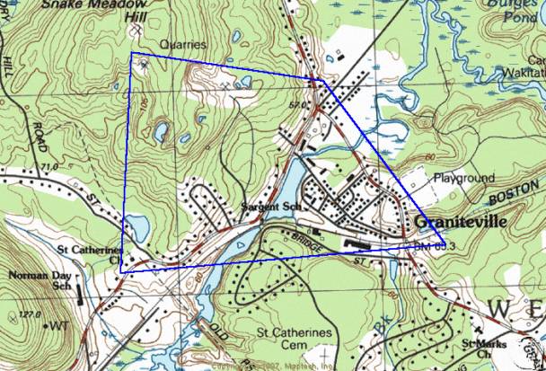
Forge Village Historic District
Description
Introduction
Forge Village is an industrial and residential village in the town of Westford, Middlesex County, Massachusetts. It is the location of the former Abbot Worsted Mill that comprises the central architectural feature of the village. A branch of the former Boston and Maine Railroad passes through the village along the banks of Stony Brook. Architectural resources consist of moderate to well-preserved residential, institutional, commercial and industrial properties built during the Colonial to Early Modern Periods. Most buildings are either multiple or single unit factory worker housing but several commercial and industrial resources exist as well as a former religious mission, a historic playground and two former schools. Two hundred seventy-four historic buildings exist in the district. One historic site and five historic structures are also present. Architectural styles include Colonial, Federal, Greek Revival, Second Empire Victorian Eclectic, Queen Anne, Colonial Revival, Bungalow and Cape Cod. Boundaries of the district are determined by changes in density of historic resources and by topographic changes.
The town of Westford is located in the coastal lowland
region of the commonwealth, approximately 10 miles south of the New Hampshire
border and 30 miles west of Boston. The
town is bordered on the east by Chelmsford, on the south by Acton and Carlisle,
on the west by Groton and Littleton and on the north by Tyngsborough. The area of the town is 31 square miles.
The village is set along the banks of Stony Brook and on the sloping hills to the north and south. Small residential lots with single and multiple unit dwellings are typical with the central section of the area occupied by the multitude of large industrial buildings of the former Abbot Worsted Company (now Courier Corporation, a textbook printing company). Physical relationships of the buildings varies from dense residential development, such as on Smith and Orchard Streets, to large former agricultural homes on large lots, as on West Prescott and Pleasant Streets. The towers of the former Abbot Mill are visible from many points in the village. Residential buildings are typically within 25 feet of streets and arranged in a dense pattern typical of company-built housing from the late 19th and early 20th century. Industrial properties are built of brick and set close to the road, forming an industrial streetscape along the east side of lower Pleasant Street. The core of the district is where Pleasant Street crosses the former Boston and Maine Railroad and joins East and West Prescott Streets. The combination of industrial and commercial activity and rail traffic creates a village atmosphere similar in nature and size to that of Graniteville, one mile to the east. The Forge Village Historic District retains integrity of design, feeling, association, materials and workmanship.
Development
Members of the Prescott family of Groton began occupying Forge Village during the Colonial Period for the purpose of operating their grist mill on Stony Brook and, later, manufacturing iron from bog-ore they mined in Groton. Presence of mills and the forge is reflected on maps produced in 1795, 1830 and 1855. The Stony Brook Railroad began service in the valley in 1848 and provided a connection between Lowell and Ayer, two important regional rail hubs. Shortly after its completion, several of the railroad’s board members introduced large-scale iron-manufacturing to the village. The forge began manufacturing axles and other machined iron parts in 1853 under the name Westford Forge Company. Customers included the Stony Brook Railroad, machine shops in Lowell and Lawrence and local shops. The forge remained in business until 1865 when the Forge Village Horse Nail Company overtook the forge’s operations. The nail company occupied the former forge building until 1877 when it too went out of business. Subsequently, the Graniteville-based Abbot Worsted Company acquired the forge and expanded their manufacture of carpet yarn here in 1879. They acquired the old forge which served as the manufacturing facility for woolen goods until it was replaced with the current brick mill in 1910.
Abbot Worsted began its program of intensive residential construction for its workers during the late 19th century. Bradford Street, which was first developed around 1885, is the site of the district’s earliest worker housing. After that time, the company began recruiting workers from Ireland, Scotland, Russia and other European countries to fill the demand for labor. Immigrants occupied the neighborhood in increasing numbers until the mid 20th century when the wool industry in New England had entered decline. During that time, residential subdivisions had been built on Abbot, Palermo, Orchard, Pine, Lincoln, Elm, Smith and Pershing Streets. These side streets of detached single and multiple family residences lend the district a great deal of its character. They are second in importance only to the Abbot Mill Complex on Pleasant Street
Colonial Period Residential Architecture 1620-1775
The Heald House at 62 Pleasant Street, built ca. 1730, is a Federal style side-gabled cottage of five by two bays and one and one-half stories. A single-story ell connects the house to a side-gabled barn at the south side of the plan and a hipped porch expands the plan at the north. A shed dormer occupies the front slope of the roof. The center entry is covered by a hipped porch, which was added after the original construction. Windows are modern 8/8 double-hung sash and the two chimneys at the roofline are brick. Walls are clad in wood clapboards, the roof in asphalt shingles and the foundation is built of cut granite. Openings in the facade of the barn are occupied by a roll-up garage door, a sliding vehicle door and by a 6/6 double-hung sash. A wooden ventilator is at the roofline. The house and barn are in good condition and may be the oldest buildings in the district. They are set 25 feet from State Route 225.
The Colonial cottage at 39 Pleasant Street, built ca. 1765, is a one and one-half-story, five-bay side-gabled residence built with sparse classical ornament. A one-story ell projects from the rear of the house and the front slope of the roof is expanded by a tall gabled dormer. A screened porch enlarges the plan at the left elevation. The house is clad in wood clapboards, the roof in asphalt shingles and the foundation is cut granite. Decorative elements include the classically molded trim and sidelights around the center entry and gable returns in the gabled dormer. First story windows are 1/1 double-hung sash with simple trim. Second story sash are smaller with multiple panes. Three chimneys rise from the roof, two of which are located on the ridge. The third is in the rear ell. The house is in good condition and is located on State Route 225.
Federal/Early Industrial Period Residential Architecture 1775-1853
The house at 7 West Prescott Street was built ca. 1800 near the core of the village. The front-gabled form is three by four bays and one and one-half stories. Gabled dormers and a center brick chimney occupy the roof the house. Walls are clad in wood clapboards, the roof in asphalt shingles and the foundation is built of cut granite. Windows are 6/6 double-hung sash. The house is in fair condition and retains integrity of design and materials.
The house at 23 Pleasant Street was also built around 1800 and has some similarities of scale and materials to the house at 13 Pleasant. The side-gabled, five by two bay plan rises two and one-half stories and is enlarged at the rear by two perpendicular ells. The northern ell has lower posts than other parts of the house and may predate the Federal Period main block. A pedimented porch with classically molded piers, a closed gable and molded cornice covers the center entry and, with the corner boards on the main block, represents the principal ornament on the house. The entry is flanked by ½ length sidelights and classical trim. Windows are 1/1 modern sash in the left (north) and 6/6 wooden double-hung sash on the right. The ells are fenestrated with 6/6 sash. Walls of the house are clad in wood clapboards, the roof in asphalt shingles and the foundation is built of cut granite. Two brick chimneys rise from the ridgeline. The house is in good condition and retains integrity of design. A front gabled garage of one bay with a roll-up door exists behind the house on Oak Street.
The Levi Prescott House at 25 Pine Street is another Federal style residence built around 1800. Like 10 Pleasant Street, this has brick end walls with integrated chimneys. The central five-bay, two-story wood-framed portion has been rebuilt due to a late 20th century fire, but the design nearly replicates the original according to photographs taken before the fire. Exterior walls are clad in wood clapboard, the roof in asphalt shingles and the foundation is built of cut granite. Windows are 8/12 double-hung sash with beaded trim. The center entry is surmounted by a fanlight and flanked by ½ length sidelights. An attached two-bay garage expands the plan at the east side. The house is in good condition and represents a strong effort at reconstruction after fire.
The Wright House at 13 Pleasant Street was built around 1820 in the Federal style. The five by two-bay, two-story form has a low, hipped roof, matched brick chimneys rising from the side walls and symmetrical fenestration typical of the style. Decorative elements include the corner pilasters, molded cornice and classical trim at the center entry. Windows are 6/6 double-hung sash with beaded trim. The exterior is clad in wood clapboards, the roof in asphalt shingles and the foundation is built of cut granite. A low stone wall lines the yard at the street. The house is well maintained. A two-bay, front-gabled garage with a single roll-up door occupies the rear of the lot.
The house at 34 West Prescott Street was built around 1840 with elements of the Greek Revival style. The three by three-bay gable-front main block is enlarged by a full-width hipped porch and by a one and one-half-story west side ell that attaches the barn to the house. A shed dormer occupies the front slope of the ell and an integral porch covers the entry. Decorative elements consist of the molded cornice, gable returns, corner pilasters, wide classical trim and sidelights at the side-hall entry. Windows are 6/6 double-hung sash with beaded trim. Those on the first story are extended in length, as is common in buildings of this style. Walls are clad in wood clapboards, the roof in asphalt shingles and the foundation is cut granite. The barn is a side-gabled form of two stories and three bays. It is also clad in wood clapboards and built on a cut granite foundation. A granite retaining wall exists between the house and barn. The house and barn are in good condition and retain integrity of materials, design and location.
Industrial Period Residential Architecture 1853-1910
The house at 27 West Prescott Street was built around 1860 with elements of the Victorian Eclectic style. The three by four-bay, two-story main block is enlarged by an ell and attached barn. A porch covers the front and side elevations of the front-gabled house. Decorative elements include gable returns and a molded cornice. Windows are modern 6/1 double-hung sash. The walls are clad in vinyl clapboards, the roof in asphalt shingles and the foundation is cut granite. The attached barn is accessed by a single roll-up vehicle door in the facade. Windows in the barn are 6/6 double-hung sash and walls are clad in vinyl clapboards. A modern detached shed and post and rail fence are also present. The house is in fair condition.
The Sartell House at 44 Pleasant Street, ca. 1865, is a Victorian Eclectic style residence set back farther from the road than others in the neighborhood. It is a two and one-half-story, front-gabled, three by four-bay form with a rear ell of one and one-half stories. A two-story gabled bay occupies the north (right) elevation. Exterior walls are clad in wood clapboards, the roof in asphalt shingles and the foundation is cut granite. Decorative elements are varied and include wide classical trim at the side-hall entry, corner pilasters and wide frieze boards at the cornice. The two-story gabled bay and the front gable of the main block have gable returns and molded cornices. Molded hoods articulate the 2/2 double-hung sash and a flat-roofed porch with carved brackets covers the double-leaf entry. An interior brick chimney rises from the roof peak. The house is well maintained and retains integrity of design and materials.
The Victorian Eclectic style house at 15-17 Bradford Street was built as one of several units of worker housing around 1885. The main block is a two and one-half-story, side-gabled duplex of four by two bays with two gabled dormers on the front slope of the roof. A one-story ell expands the plan at the rear. Exterior walls are clad in wood clapboards, the roof in asphalt shingles and the foundation is built of cut granite. Decorative elements include the entry hoods with carved brackets, the frieze board at the eave, corner boards and molded window surrounds. A detached front-gabled garage occupies the rear yard. The house is well maintained, retains integrity of materials and design and is identical in form and detail to 19-21 Bradford Street.
The multiple unit residence at 8-10 Bradford Street is one of several similar buildings on the street constructed as worker housing for the Abbot Worsted Mill around 1885. The house is a four by two-bay, side-gabled Victorian Eclectic style duplex with an ell attached to the rear elevation. Exterior walls are clad in wood clapboards, the roof in asphalt shingles, and the foundation is built of cut granite. The restrained ornament consists of wide trim boards at the eaves, corner pilasters and wide window surrounds. The double entry is protected by a flat roofed entry hood with exuberantly carved brackets at the sides. The building is identical in design to 24-26 Bradford Street.
The front-gabled residence at 36 Pleasant Street was built around 1890 in the Victorian Eclectic style. The two by two-bay plan is enlarged at the right elevation by a one-story ell built perpendicular to the main block and by a one-story Mansard-roofed bay in the first story of the facade. The side-hall entry is also covered by a Mansard-roofed hood with carved brackets at the sides. Decorative elements include brackets at the corners of the eaves, corner boards and the ornament in the gable peak. Exterior walls are clad in wood clapboards, the foundation is built of cut granite and the roof is sheathed in asphalt shingles. Windows are 2/2 double-hung sash with molded trim. A detached, one-bay garage clad in wood clapboards and accessed by a modern roll-up door is in the side yard. The house is well maintained and retains integrity of materials and design. The house is similar in form and detail to 30 Pleasant Street and was probably built at the same time. The house at 38 Pleasant Street has a similar plan and form but has been relieved of its architectural detail.
The house at 8 East Prescott Street was built around 1890 in the Victorian Eclectic style. The front-gabled duplex is four by five bays and rises two and one-half stories. The plan is expanded by a full-width, flat-roofed front porch with a balustrade at the second story. Decorative elements include corner boards, a closed gable, jigsawn brackets on the porch posts and a molded cornice. Windows are modern 2/1 double-hung sash with beaded trim. The sash in the gable-peak is articulated with a denticulated hood. Exterior walls are clad in vinyl clapboards, the roof is sheathed in asphalt shingles and the foundation is built of cut granite. A brick chimney with corbel cap rises from the west slope of the roof. A detached two-bay carriage house clad in wood clapboards occupies the back yard. The house is well maintained and bears a strong similarity of form to its neighbor to the east, 10 East Prescott Street.
The Victorian Eclectic style house at 10 East Prescott Street was built around the same time as its westerly neighbor, 8 East Prescott Street, and shares some elements of form. The main block of the two and one-half-story, building is three by four bays with a wrapping hip-roofed porch across the front and west side. A gabled bay projects from the west elevation creating a cross gabled plan. Ornament consists of corner brackets at the eaves, jigsawn porch posts with brackets and molded cornice. Exterior walls are clad primarily in wood clapboards except for the front gable peak which has wood shingles. The roof is clad in asphalt shingles and the foundation is built of cut granite. Windows are modern double-hung sash with beaded trim. A brick chimney rises from the west slope of the roof. The house is in fair condition.
Three Victorian Eclectic style multiple unit dwellings on Canal Street were built around 1900 and share elements of form and ornament. Houses at 4, 6 and 8 Canal Street are 6 by 2-bay, side-gabled forms of two and one-half stories. Some examples of original 2/2 double-hung sash remain at 8 Canal Street but the majority of windows have been replaced. The house at 4 Canal Street retains its wood clapboard exterior but the others have been re-sided with vinyl. The main block of 8 Canal Street is enlarged by a gabled dormer.
The house at 4 Pine Street was built around 1906 with restrained Victorian Eclectic style details. The side-gabled, one and one-half-story form is built on a three by two bay plan. Three examples have enclosed hipped entry porches projecting from the facade. Architectural details include gable returns, molded cornice and corner boards. Walls are clad in vinyl clapboards, the foundation is built of granite and the roof is clad in asphalt shingles. This and the three similar examples on Pine Street are well maintained but have been altered with the addition of synthetic siding. Four Single family homes on Pine Street (Numbers 4, 6, 8, 10) and nine on Pond Street (Numbers 1, 2, 3, 4, 5, 6, 8, 14, 16) share aspects of form and detail due to their construction by a single contractor to the Abbot Worsted Company. These are similar in form to the group described below on Orchard Street although the entry porches on Pond Street are either pedimented or enclosed and not hipped with carved brackets. Several of the houses on Pond and Pine Streets have detached garages built in a front-gabled, single-bay plan with novelty board cladding. Historic detached garages exist at 4, 8 and 10 Pine Street and 2, 5, 8, 14, and 16 Pond Street. The example at 10 Pine Street has been altered with the installation of vinyl siding but retains the original form.
Modern Period Residential Architecture 1910-1956
Sixteen houses on Orchard Street share a side-gabled, one and one-half-story form of three by one bays. Houses at 1, 3, 5, 6, 7, 8, 9, 10, 11, 12, 13, 14, 15, 16, 17, 19 Orchard Street were built around 1911 and are all identical in form and detail although some have been altered with the addition of porches and synthetic siding. Examples that survive with few alterations are at 1, 3 and 7 Orchard Street. These are clad in wood clapboards, have 6/6 double-hung sash with hood moldings, a Victorian Eclectic style entry hood with carved brackets at the sides and gable returns. Foundations are built of brick and roofs are sheathed in asphalt shingles. The houses on Orchard Street are similar in form and detail to the groups described above on Pond and Pine Streets. Several of the houses on Orchard Street have detached garages built with a front-gabled, single-bay plan with novelty board cladding. Historic detached garages exist at 3, 4, 7 and 8 Orchard Street. Also, the garage at 6 Orchard Street is a historic pyramidal hipped example.
Pershing Street is a short, semi-circular residential subdivision with three multiple unit dwellings and some single-family homes, all built around 1920. Two of the multiple unit dwellings, located at 10-12 and 14-16 Pershing Street are identical in their unusual forms and share some Victorian Eclectic details. The main block is a side-gabled, two and one-half-story, four by two-bay form oriented parallel to the street. The main block is enlarged by a half-width shed dormer and by matching entry porches projecting from the sides of the facade. A convex slope articulates the roofs of the porches. Both houses are clad in wood shingles with uncut stone foundations. The house at 10-12 Pershing Street has asbestos shingles on the roof and jalousie windows in the projecting entry porches while 14-16 has an asphalt shingle roof and fixed multiple-pane sash. Single family homes on Pershing Street are typically two stories or less in height and bear restrained architectural detail. For example, the house at 1 Pershing Street is a front-gabled block enlarged by a shed dormer and an ell at the right side. A large central chimney, built of brick, projects from the center of the roof.
A house with a form similar to the duplexes on Pershing Street exists at 3-7 Lincoln Avenue, however it is ornamented with Colonial Revival style details. The central block is a side-gabled, five by two-bay, two and one-half-story form with symmetrical fenestration typical of the style. The main block is enlarged at the side elevations by matching ells that project from the front of the house. The ells contain integral porches with roofs supported by classically molded piers. The center entry in the main block is trimmed with paired pilasters, a blind fan and a pediment. Windows are primarily 6/6 double-hung sash except in the tripartite sash in the side elevation which have 4/4 sash flanking 6/6 sash. Exterior walls are clad in wood shingles, the roof in asphalt shingles and the foundation is uncut stone. Three brick chimneys mark the roofline and lunettes light the side gable peaks. It is in fair condition.
A group of 13 houses on Abbot Street was built as Abbot Worsted worker housing around 1940 in the Cape Cod form. The example at 23 Abbot Street is typical. It is a rectangular one and one-half-story, side-gabled, three by two-bay form. A one-bay, front-gabled garage is attached to the south side by an open porch. The roof of the house is clad in asphalt shingles, the walls in wood clapboards and the foundation is cinderblock. Windows are 8/8 double-hung sash with beaded trim. The center entry is surrounded by ½ length sidelights and a hood molding above. Similar designs exist at 1, 3, 7, 11, 12, 13, 15, 16, 17, 19, 20 and 21 Abbot Street. The house at 3 Abbot Street was featured in a news article published around 1939 describing the five rooms on the interior and noting that the price of a furnished house of the type cost $3800. Detached garages were built on Abbot Street at numbers 3, 11 and 13 around the time of construction of the houses. Attached garages exist at numbers 1, 7, 12, 15, 16, 17, 19, 20, 21 23. Seven houses located on the west side of Abbot Street and two on the east are not historic and were built between 1960 and 1985. Other groups of Colonial Revival style and Cape Cod form Abbot Worsted worker homes were built around 1940 on Elm Street. Houses at 6, 8 and 9 Elm Street are Colonial Revival style homes and houses at 13, 15, 17 and 18 Elm Street are Cape Cod forms built around the same time. Lincoln Avenue, Pershing Street and Smith Street were also built at this time and intended for occupation by Abbot company workers.
Institutional Architecture
The Prescott House/Abbot Worsted Company Hospital at 10 Pleasant Street was built between 1760-1800 in the Federal Style. It is a five by two-bay, two and one-half-story form with a rear addition of one story. A one-story porch is attached to the rear addition. The building is clad in wood clapboards on three sides with the southeast wall and foundation being brick. The roof is sheathed in asphalt shingles. Eaves are trimmed with a slim cornice and corner boards mark the sides of the facade. The entry has a wide surround with pilasters and a full entablature above a row of transom lights. The double-hung 2/2 sash have simple hood moldings above. There are two brick chimneys at each side of the house in a typical Federal arrangement. A four-foot high retaining wall exists at the northwest side of the house and exposes the brick foundation. The house overlooks the Abbot Worsted Mill complex and Forge Pond. Another Federal style residential example in the district is at 13 Pleasant Street.
The former District Three Schoolhouse at 35 Pleasant Street was built of brick around 1825. The three by two-bay, front-gabled form rises one and one-half stories and has a low brick chimney at the ridgeline. Access is through the unornamented center entry. Windows are modern double-hung sash. Little ornament exists on the exterior of the former school. An addition of one story has been made to the rear of the building. The
facade, however, retains much of its historical appearance.
The former Cameron School at 20 Pleasant Street was built in 1872 and remodeled in 1908 in the Colonial Revival style and is now in use as a senior center. The two-story, deck-hipped building is constructed on a five by seven-bay plan that has been expanded in the rear by a two-story addition. The central three bays of the facade comprise a projecting pavilion which is flanked by matching shed roofed entry porches. The roof is surmounted by an octagonal ventilator. Decorative elements include corner boards with molded caps at the corners of the main block and of the pavilion on the facade, piers with molded caps supporting the shed entry porches, prominent hoods above the sash on the facade and side elevations, and ornamental panels between the first and second story windows. The roof is clad in asphalt shingles, the walls in wood clapboards and the foundation is built of cut granite. Windows are 6/6 double-hung sash and are arranged in groups of six on the side elevations. The former school is well maintained and retains integrity of materials and design.
The former Saint Andrew’s Episcopal Mission at 25 Pleasant Street was built in the Shingle style in 1903 and is now in use as a residence. It is a two and one-half-story form with a central, side-gabled block and matching front-gabled secondary masses attached to both side elevations to form a broad H-shaped plan. The architect was the Reverend Thomas L. Fisher. The builder was Westford resident, A. Ferguson. A Saint Andrew’s cross as is found on the flag of Scotland designed in 1385 during the war of Richard II, ornaments the facade of the building.
The Forge Village Fire Station is located at 1 East Prescott Street and was built in 1941. It is a two by three-bay, two-story form with a front-gambrel roof and two vehicle doors in the facade. The building is constructed of brick with an asphalt shingled roof and concrete foundation. Shed-roofed dormers enlarge the second story.
Commercial Buildings
The former Splain Store at 2 East Prescott Street is a Victorian Eclectic building built ca. 1895 at the corner of East Prescott, West Prescott and Pleasant Streets in the core of Forge Village. It is a three-by two-bay, front-gabled form with a hipped enclosed porch across the entire first story of the facade. A one-story ell is attached to the north (left) elevation and a shed dormer expands the roof above. Wood clapboards sheath the exterior walls, asphalt shingles cover the roof and the foundation is built of cut granite. Little ornament remains on the exterior of the moderately well-maintained building.
The former Pigeon Family House and Store at 16-18 Pleasant Street was built around 1910 and is currently in use as a multiple unit dwelling. The two and one-half-story, front-gabled, three by five-bay Queen Anne building is sheathed in wood shingles on the second story and wood clapboards on the first. The roof is sheathed in asphalt shingles and the foundation is built of uncut stone. Decorative elements consist of the change in exterior cladding between the first and second stories separated by a flared course of shingles, a small semi-circular gable ornament, flat window hoods, brackets at the corners of the eave line and a hipped entry hood with carved brackets. Windows are 2/1 double-hung sash. A single brick chimney marks the center of the roof line. The house is well maintained and retains integrity of materials and design.
The former offices of the Abbot Worsted Company are located at 4 Pleasant Street, across the street from the Abbot Mill Complex. The residential-scaled building was constructed in 1923 and is now in use as offices of a company unaffiliated with the mill. The Colonial Revival style building is a one and one-half-story, side-gabled, five-bay form built mainly of brick. An attached garage of five bays is at the rear of the building. Secondary masses include a semi-circular center entry porch and two gabled dormers on the front slope of the roof. Construction is brick with a wide denticulated wood entablature. The roof is slate shingles, and the foundation is built of brick. Colonial Revival design elements include the wide frieze, Ionic columns supporting the entry porch, pedimented dormers, brick corner quoins and flat arches of brick over the windows. The entry is surrounded by sidelights and a transom as well as a wood frieze and brick flat arch. Windows are 12/12 double-hung sash. The well-maintained former Abbot office building is a more formal Colonial Revival design than most others in the village and retains integrity of design and materials.
Forge Village Auto Service at 1 West Prescott Street is a one-story, three-bay, ridge hipped building that houses an auto and marine equipment repair business. It was built around 1940 with elements of the foursquare form. The facade is pierced by two vehicle doors, a pass door and a single window. The building is sheathed in wood clapboards, the ridge-hipped roof in asphalt shingles and the foundation is built of cinderblock. It is utilitarian in function and design and has little ornament. A single chimney is located east (left) of the center of the roof ridge. Vehicle openings are filled with glazed roll-up doors with simple trim. The pass door and window also have simple trim.
Industrial Buildings
The former Abbot Worsted Mill at 7 Pleasant Street is a complex of industrial buildings, the principal members of which are constructed of brick to a level of three stories. Two ornamental Victorian Eclectic style towers face Pleasant Street and contribute defining elements to the center of the village. The older of the two principal brick mill buildings is the Yarn Mill, which is built over the canal south of Stony Brook and has one wall adjacent to Pleasant Street. It is largely rectangular but the northwest corner is canted or beveled to accommodate the passage of Pleasant Street, the slope of which causes the building to rise three stories at its north end and two at the south. The focal point of the exterior of the mill is the Italianate style tower that faces Pleasant Street and signals the location of the main pedestrian entry. The square tower is three stories in height with a flat or gently sloping roof, brick corbels, a recessed central panel between pilasters with molded caps. An arched opening with rounded brick hood pierces the upper level of the tower and may contain a carillon. A granite marker built into the tower is carved with the title “ABBOT & CO / 1857-1887”, the later date indicating the time of construction of the Yarn Mill. The entry at the base of the tower is a Colonial Revival style door with transom and sidelights under a pedimented hood. The Colonial Revival entry replaced a Victorian design in the mid 20th century. The door is reached from Pleasant Street by crossing a short bridge over an excavated area between the building and a granite retaining wall. Twenty bays with sash set into recessed panels line the Pleasant Street elevation. Windows in the Yarn Mill are paired, wood-framed, multiple-pane double-hung sash with brick lintels and arched tops. Interior beams are wood supported by wood columns. The lowest level of this building housed power generating equipment and machinery. At the time of construction, water wheels driven by the flow of Stony Brook transmitted power upstairs via a system of belts and pulleys. Pulleys and shafts are visible inside the building in some places. Steam engines were in place by the late 19th century and may continue to exist.
North of the 1887 Yarn Mill is part of the 1910 Top Mill. (Top is a type of wool that has been relieved of its shorter fibers by combing, a procedure necessary for making worsted wool.) This is also a three-story brick building that faces Pleasant Street and is articulated with an ornamental tower capped by a hipped roof and belfry. The six-bay facade faces northwest and is articulated with Victorian Eclectic style corbels and arched window hoods. A recessed panel in the tower bears a plaque inscribed “1910”. Windows are multiple-pane, double-hung sash that are paired in some openings. This is the facade located closest to Stony Brook, the intersection of Pleasant and Prescott Streets and the railroad, all of which comprise the core of the Forge Village Historic District. Interior construction of this building consists of iron I-beams and lattice trusses for supporting the wide interior work spaces. The interior of the top floor is lit by windows in the monitor roof.
A third mill building exists east of the Yarn and Top Mills and may be seen to their rear. This was additional space for performing the work done in the Top Mill. Like the other two, it is built of brick and has arched openings for the windows which are multiple pane, double-hung sash. Additional metal clad and wood-framed buildings exist to the east and serve primarily as storage. One is brick and has a date stone inscribed 1951. This is connected to the tall brick smoke stack and may have served as the power house. It is currently in use as storage. Adjacent to the Power House and the second Top Mill is a Gate House, possibly built for controlling the water level in Stony Brook. It is a square, pyramidal hipped building. Other buildings to east are Butler-type prefabricated units that serve as storage.
The former electric powerhouse for the Fitchburg and Lowell Street Railway was built around 1907 and is located at 4 East Prescott Street. It is a one-story brick building built as a two bay plan with a one-bay, wood shingle addition to the east side. Openings in the original brick mass are arched and filled with a door and paired double-hung sash. The opening in the addition is filled with a roll-up garage door. The top of the facade of the brick section is articulated with a stepped gable and tile coping. A corbel table ornaments the eave of the right (west) side of the building. Brickwork with Victorian Eclectic style details resembles that found on the much larger Abbot Mill located across Stony Brook to the south.
Structures
The Westford Forge Company dug out and enlarged in 1853 the canal or millrace between Forge Pond and the Abbot Mill Complex. It runs parallel to the natural outflow of Forge Pond and West Prescott Street. The canal crosses under Pleasant Street south of the Railroad to achieve a total length of approximately a tenth-mile. The canal is approximately twenty feet across and eight feet deep. It is lined with granite ashlar and allows a stream of water approximately three feet deep to flow from the pond to the opening in the lower level of the Yarn Mill where water and steam power equipment was housed. The dam across the outlet of Forge Pond is located just south of West Prescott Street and west of Pleasant Street. The dam impounds around five feet of water to allow a stream of three feet in depth to flow through the canal. The structure is submerged beneath a sheet of water flowing over its top.
The former Abbot Worsted Company ball fields are located at the extreme west edge of the district on West Prescott Street. They are currently owned by the town and serve as public recreation space. There are two historic baseball diamonds as well as several modern facilities such as a deck hockey rink, basketball courts, lights and sheds. The diamonds are flanked by dugouts and chain link fences that are not historic.
Statement of Significance
Summary
The Forge Village Historic District is eligible for the National Register of Historic Places under criterion A for its associations with trends in 18th, 19th and 20th century industry and village planning practices. The industries of iron forging and woolen yarn manufacture were carried out over the course of nearly three centuries at the core of the district. The current form of the streets and homes of the district is the result of town planning practices in use by the Abbot Worsted Company during the late 19th and early 20th centuries.
The village is also eligible for the National Register under criterion C for its embodiment of the distinctive characteristics of its 18th, 19th and early 20th century architectural and industrial historic resources. The hundreds of worker houses, Victorian Eclectic style mill buildings and the street pattern focusing on the mill are illustrative of historic construction methods and styles. The district retains integrity of design, craftsmanship, setting, feeling and association.
The period of significance for the district is 1730-1956, which opens with construction of the Heald House, the district’s oldest surviving residence, and closes with the Early Modern Period of history. There are approximately 280 contributing buildings, sites, structures and objects in the district.
Contact Period 1500-1620
Algonquin-speaking Wamesit, Pawtucket and Nashoba tribes of Native Americans inhabited the area between the Concord and Merrimack Rivers. Habitation of Westford was concentrated near wetlands such as those along Stony Brook. Projectile points have been recovered in these areas and in upland sites, which indicates scattered hunting activity throughout the town. None of the three suspected Native settlements in the town were determined to be in Forge Village although it is possible that tribe members exploited the hunting and fishing opportunities in the area. Fishing on Stony Brook during the Contact Period is indicated by the existence of a fish weir that was recorded at the outflow of Forge Pond in the mid 17th century near the site of the former Abbot Mill. Travel by Native Americans through the area is conjectured to have been along Stony Brook, possibly the current alignment of North Main Street.
Colonial Period 1620-1775
Travel by White settlers between Chelmsford and Groton began in the mid 17th century on the road that paralleled Stony Brook on the south side (now Forge Village Road, Pine Street, Cold Spring Road) that connected West Chelmsford to Forge Village and Groton. At this time, Westford was part of Chelmsford and residents of that town were responsible for improving the transportation network. In 1655, the town of Groton resolved to build a road leading east to Forge Pond that would connect with roads to West Chelmsford. Westford was a hinterland at this time, nearly devoid of settlers, and was viewed as little more than a geographical barrier between the established villages of Groton and Chelmsford. Settlement was sparse in the town and in Forge Village. No buildings survive from before 1730.
A Native American fish weir existed by the mid-17th century on Stony Brook at the outlet of Forge Pond, part of the town of Groton at that time. According to Hodgman’s history of Westford, the town of Groton bought the weir from the Native American named Andrew some time around 1680. At about the same time, the blacksmith and Groton landholder Jonas Prescott built the first iron works at the location and began the 300-year history of industrial activity in Forge Village. Mr. Prescott lived with his wife Mary at the southwest corner of Pine and Town Farm Roads and mined bog-ore in Groton to be smelted into iron at the mill site on Stony Brook. The iron was used for making candlesticks, farm tools and household items such as irons according to local historian Gordon Seavey’s 1988 article on the influence of Stony Brook. A grist mill might also have existed at the outflow of Forge Pond at this time according to town histories of Westford and Chelmsford. A relative of Jonas named Jonathan Prescott built for protection from Natives a garrison house near the forge, which survived until 1876.
Westford, which acquired independence from its parent town of Chelmsford in 1729, retains original boundaries except for a narrow triangle of land in the western part that included Forge Village. The triangle remained part of Groton until 1730 when it was ceded to the newly established town. Here were contained the improved forge of Jonas Sr. (b. Lancaster, Ma, 1648) and his wife Mary Locker; the homes of town clerk Jonas Prescott Jr. (b. ca. 1678 d. 1750) and his wife Thankful Wheeler; grandson Jonas (b.1703) and his wife Elizabeth Spalding. The great-grandson Lieutenant Jonas Prescott, (b. 1727 d. 1813) also occupied a house in the village, served as Lieutenant in the French and Indian War, representative to the Massachusetts General Court from 1758-69 and is described as a forgeman in the genealogy in the town history. He lived at 25 Pine Street, built ca. 1780. The Prescotts made an immeasurable impact on the village by beginning its industrial activity and maintaining a family interest for several generations.
Other residents around 1730 included Captain Jabez Keep (b. 1706), a deer reeve and county road commissioner who may have operated a saw mill in Forge Village based on the note in the town history that he provided 1500 feet of lumber for construction of a belfry in 1763; Thomas Heald, whose house at 62 Pleasant Street is the oldest in the district, built ca. 1730, and later owned by David Lawrence and the Guerney Family; Ebenezer Townsend and Abner Kent who were petitioners in 1730 to the Massachusetts General Court in favor of annexing part of the town of Groton to the town of Westford, probably to be closer to the meeting house; and Ebenezer Prescott who probably was also a forge man and brother of Captain Jonas Prescott. The Francis Hosmer House at 39 Pleasant Street may have been built around 1765 according to previous research. Other residents probably lived in the area and practiced agriculture or were employed in the forge. Forge and mill buildings were made of wood, were powered by water, and were probably two stories in height or less. No period industrial buildings survive.
Westford bears significance as a town with many residences that retain distinctive Colonial Period fabric, design ideas and details. Colonial Period architecture in Forge Village is similar in form, materials and design to other examples in the Westford Center National Register Historic District and throughout the town. The Heald and Hosmer Houses, and the 17th century Jonathan Prescott tavern (no longer standing northeast of the crossing of Pleasant Street over Stony Brook) for example, are Colonial style residences built of wood with classical details and symmetrical facades, a description that fits the Colonial Period house at 2 Hildreth Street in Westford Center.
Federal/Early Industrial Period 1775-1853
Iron manufacture continued adjacent to a fulling mill that had been established during the Federal and Early Industrial Period according to the 1795 series map. The iron works were located on the site of the existing mill building, south of the stream and east of Pleasant Street. The fulling mill was on the opposite (north) side of Stony Brook. Personal recollections of the early decades of the 19th century were transcribed in the 1883 town history and depicted a village with agricultural activity, small industry along the brook and frequent passage on the county road by travelers from Boston, Vermont and New Hampshire. The image is of a busy small village with a high degree of self-sufficiency based on its ability to supply nearly all of its own economic needs. The Early Industrial Period closed with the 1853 corporate organization of and sale of stock in the Westford Forge Company.
Transportation Routes
Late 18th century travel through Forge Village was on what is now West Prescott Street to Groton; Pleasant Street led southeast to Concord and Pine Street led out of the village to the east toward Westford Center (NR District, 1998). There may have been a path along the current route of East Prescott Street, north of the brook but it is not represented as a road on the 1795 series map of Westford. Travelers between Boston, southern New Hampshire and Vermont used West Prescott and Pleasant Streets, providing a great many customers for the tavern, in operation throughout the period northeast of the crossing of West Prescott Street over Stony Brook (currently the site of Spinner’s Store). While it is possible that alternative routes of travel existed through Forge Village during the period in the form of unnamed paths, possibly across private land north of Stony Brook, West Prescott, Pleasant and Pine Streets would remain the only roads depicted on maps of the district until the addition of East Prescott Street on the 1875 Beers map. The town report of 1840 indicates that Asia Nutting built a stone bridge near the forge, which may have carried the current Pleasant Street over Stony Brook but has since been replaced.
The 13-mile long Stony Brook Railroad opened for business parallel to its namesake brook in July 1848 between South Groton (now Ayer Center) and North Chelmsford. The company was based in Lowell and built the road primarily to ship manufactures along Stony Brook to its distribution points, but also offered passenger service. Indeed, Forge Pond was touted by a local resident in the early years of the Stony Brook Railroad as a recreational destination, easily accessible by rail and located in a quiet rural setting.
The railroad never owned any rolling stock (engines or cars) and was leased upon its opening by the Nashua and Lowell Railroad, a larger operation with rolling stock operating between the manufacturing centers of its name. The improved shipping opportunities provided by the railroad allowed towns on Stony Brook to grow much faster than before. Forge Village and Graniteville, one mile to the east (National Register District, pending review) were the villages in Westford that benefited by their new ability to ship products to customers in Lowell and across New England.
Population
Population in the district in the late 18th century was only around 20 adults, although the number was sufficient to begin the industrial development of this part of the Stony Brook Valley. Iron forging continued to drive the local economy but as many residents were farmers as were employed in manufacturing according to federal census information. With the opening of new travel routes and increasing population density after the Revolution, farmers and industrialists alike were drawn to new settlements in northern New England and Western Massachusetts. Perhaps 100 families migrated out of Westford as a whole, a number that must have included many from Forge Village. But as old residents moved out, new arrivals replaced them as forge employees and farmers.
In 1820, federal census information indicates there might have been 35 individuals in the village. Slightly less than half were employed in manufactures with the remainder in agriculture. Ebenezer Prescott was the principal member of his family involved in iron forging at this time. This was probably the Ebenezer Prescott born in 1776 and married to Hannah Wait in 1800. He lived at 10 Pleasant Street and is responsible for creating the 1795 map of Westford. His brother Jonathan Prescott (b. 1783) was the tavern keeper in Forge Village until 1845. Prior to 1850, Forge Village was superior to Forge Village in terms of its population and amount and value of industrial goods produced.
The equal ratio of industrial employees to agricultural workers indicated by the 1820 census remained intact through the time of the 1840 census. Ebenezer Prescott and other members of his extended family remained heavily involved in the iron forging business. By 1850, a fifth man named Jonas Prescott (b. 1810) and Nathan Prescott (b. 1817) were the principal iron manufacturers, labeled “forgeman” in the census. Employees of the forge were described as laborers, of which there were four in addition to Samuel Prescott (b. 1822) who was also listed as a forgeman. Charles and Asa Prescott were labeled as traders in the village. In 1850, the approximately 80 village residents were almost all of English descent. There were two people in the village born in Canada and two from Ireland at that time. Residents attended the Congregational Church in Westford Center.
Economic Base
The 1795 series map of Westford, carried out by Ebenezer Prescott of the iron forging family, indicates the existence of a fulling mill northeast of where Pleasant Street crosses Stony Brook and the iron forge at the southeast, very near the existing mill complex. William Chandler operated the first fulling mill further down Stony Brook in the early 18th century but it is unknown who operated the one described in Forge Village at the end of the 18th century. However the Prescott family continued their deep involvement with iron forging in the village and may have been involved in the fulling mill as well. During the Federal Period, the number of forges increased to three which may have been owned by different members of the Prescott family.
Recollections of a resident printed in the 1883 town history indicate that Forge Village in 1828 was the site of a “store, hotel, three iron forges, two blacksmith’s shops, two wool carding machines, one clothier’s mill, a grist mill and a wheelwright’s shop, all located near the [existing] worsted mill”. The 1831 Hales map of the town shows a forge, an iron foundry and a tavern in the village in addition to a school and several residences. Jonathan Prescott built a significant addition to his tavern in 1817 and continued to operate it as a tavern until 1845, after which time he operated his business as a store and dance hall. Dozens of residents carried out agricultural activities as well as industrial jobs. This diversified economy provided the solid base on which the village would survive as a traditional mill community far longer than others in the region.
By 1850, two members of the Prescott family were operating separate forge companies in the village. Jonas and Nathan Prescott operated businesses of similar scale according to the value of their machinery and created nearly identical products. Indeed, these men owned more valuable machinery and stock in trade than anyone in town, including affluent Westford Center and the expanding industrial village of Graniteville. Items produced at the forges included axles, sledges, box molds, and anchor palms (the pointed end, also called a fluke on a yachtsman type anchor). Production at the forges was sufficient to attract the attention of investors from the manufacturing cities of Lowell and Nashua, several of whom were made aware of the possibilities of manufacturing in Forge Village on a large scale by virtue of their involvement with the new Stony Brook Railroad. Investments in the business by members of this group would carry the village into the next growth-oriented phase of its development.
Architecture
Institutional
The former District #3 School is located at the corner of Pine and Pleasant Streets. It was built in ca. 1825 as one of 8 district schools established in 1822. The district was divided in 1851 and students attended either school #3 or #10 in Graniteville. The building at 35 Pleasant Street served as the village’s primary education facility until 1872 when a new school was built by G. W. Howe. The old brick school was sold to David Lawrence in 1875.
Residential
The residence at 23 Pleasant Street was built prior to 1830 and is depicted on the map of Westford printed in that year. The first known owner was A. Prescott in 1855 whose occupancy is shown on the map drawn in 1855 by Edward Symmes. This may have been Abram Prescott who lived with his wife Olive and their 11 children. Abram was representative to the Massachusetts General Court in the 1820s and 1830s, town clerk in the 1820s, military captain and deacon of the First Parish Church. Abram’s youngest son, Edward, was the subsequent owner of the property into the late 19th century and had the largest amount of property among his family members, including at one valuation four separate residences.
The house at 25 Pine Street was built for Lt. Jonas Prescott around 1784 according to the family genealogy. He was born in 1727 in Westford and married in 1750/51 to Rebecca Parker. Lieutenant Prescott earned his rank while fighting in the French and Indian War. He probably operated a forge in the village. Jonas’ son Levi married Hannah Prescott in 1809 and occupied the house throughout their lifetimes. Like his father, Levi was also a forgeman. Subsequent owners were Prescott descendants Levi and Rebecca, the widows B. and L. Prescott in 1855, Levi and Ella Prescott and finally Alice Luella Prescott Collins until 1984.
The small residence at 7 West Prescott Street may have been built as a blacksmithy for Timothy P. Wright (b. 1806) according to the map from 1855. It was probably built around the time Mr. Wright married Elnora Prescott in 1832, when they lived outside the district near Beaver Brook Road to the south. Census records from 1840 indicate Mr. Wright to have worked as a blacksmith. On the maps printed in 1875 and 1889, S. A. Hamlin is depicted as the owner. This is probably Samuel A. Hamlin (b. 1832) who graduated from Westford Academy and later worked for many years as the railroad station agent in Forge Village.
The George Wright House at 13 Pleasant Street, built ca. 1820, may have been built and first occupied by Amos Heywood (1791-1875) and his wife Lydia Buck according to the 1883 town history. (p 352) Mr. Heywood later occupied a house in Westford Center on Forge Village Road. He was involved in an unspecified industry according to the 1820 census and was active in the formation of the Union Congregational Church in the Center in 1828. The forgeman George Wright acquired the house before 1857 according to the volume Westford Days. He may have bought the house around 1833, the time of his marriage to Mary Ann Prescott and occupied it until his death in 1882. George and Mary Ann’s son Ellery worked as a nail-maker in the Forge Village Horse Nail Company and may have occupied the house as well.
The Federal style house at 10 Pleasant Street was built ca. 1800 for the forgeman Ebenezer Prescott (b. 1776) around the time of his first marriage to Hannah Wait. He had two successive wives and 15 children by 1823. He was the owner of the Westford Forge Company until at least 1840 according to census information. Ebenezer Prescott was the principal member of his family involved in iron forging at this time and probably had sons in the industry. Ebenezer’s son Nathan Pollard Prescott was the subsequent owner by 1855.
Industrial
The forges were probably contained in a wood-framed building similar to the Forge Village mill depicted in the 1883 town history. It was a two-story form with a gabled roof, bell-tower at one end and a prominent smoke stack at the side. These buildings were replaced with the existing brick mills in 1910. Other industrial buildings had been constructed prior to 1853 at the crossing of Pleasant Street over Stony Brook but their appearances are not known.
Commercial
Jonathan Prescott added to his 17th century tavern at the northeast of the crossing of Pleasant Street over Stony Brook (current site of Spinner’s Store). The Colonial Period two-story, side-gabled building was enlarged with a seven-bay, two and one-half story side-gabled form in 1817. 12/12 sash are visible in historic photos. The 17th century block was demolished in the early 20th century. The 19th century block was destroyed by fire in 1976.
The depot of the Stony Brook Railroad combined the functions of ticket office, freight depot and passenger station based on the description in railroad records. The plan of the building was 20’x40’ with ornamental brackets, probably supporting the deep eaves typical of railroad stations. A platform 56’x10’ connected the building and the tracks. A siding 571’ in length existed off the main line of the road.
Many Forge Village examples of Federal architecture adhered quite closely to the period’s distinguishing design principles. As in Westford Center, stylish residences have facades rendered in wood with symmetrical fenestration. Hipped roofs, brick walls and paired chimneys also exist. Designs at 10 and 13 Pleasant Street in the district possess these characteristics and are comparable in style and scale to residences built around the same time in the civic and commercial area of Westford Center. Thus did the patterns of architectural development and artistic values exhibit themselves throughout the district and the surrounding town.
Industrial Period 1853-1910
The iron industry continued in Forge Village during the Industrial Period with the corporate organization and expansion of the Westford Forge Company. In 1853, a group of investors, primarily from Nashua, New Hampshire and Lowell but including two residents of Westford, met in Lowell to determine the improvements necessary for increasing production in the aging manufacturing facility. The placement of investment capital and construction of new mill facilities came in response to the 1848 opening of the Stony Brook Railroad and marked the Forge Village Historic District’s beginning as a company village.
Transportation Routes
The village retained the transportation patterns of the Federal/Early Industrial Period into the 1850s. Through-travel continued to pass on West Prescott and Pleasant Streets. Access to Westford Center to the east was on Pine Street. East Prescott Street does not appear on historic maps until 1875, when it is labeled Union Street and served as a thoroughfare to Graniteville. A row of houses for factory employees appears on the 1889 Walker map of Forge Village. This ultimately became Bradford Street although it is not named on the map. Other residential subdivision roads were built in succession after this time until, by 1910, new streets with company-built homes included Pond, Story and Canal Streets.
The Stony Brook Street Railway operated through the village starting in 1907. The route entered Forge Village from the east between the former Splain Store at 2 East Prescott Street and the Stony Brook Railroad. The streetcars paralleled the Stony Brook Railroad west toward Ayer. The railway company constructed a spur line up Pleasant Street to Pine Street to Westford Center and down the opposite side of Tadmuck Hill, reconnecting to the main line at Lowell Road. Streetcars eventually offered service from Graniteville, Forge Village and Westford Center to Ayer in the west and Chelmsford in the east. The railway remained in operation until 1921 when competition with the automobile forced it to close.
Population
Population levels of Forge Village remained steady between 1850 and 1860 at around 80 people. By 1890, however, Abbot Worsted employed 200 people in the village. Based on the number of employee housing units constructed by 1910, it is estimated that approximately 400 people lived in Forge Village by the end of the Industrial Period.
Residents were almost entirely of English descent until 1850 when census records show the first Canadian and Irish immigrants. In that year, two residents of each nationality were recorded in Forge Village. Numbers of both of these groups increased steadily after this time. The number of immigrants would equal that of native born residents by the 1880s. Twenty-six children were born to parents of foreign birth in 1875 according to statistics printed in town reports. In 1902, 39 of 55 births were to foreign-born parents. Other common countries of origin were England, Sweden, Finland and Italy. Beginning in 1889, the Abbot Worsted Company offered English language classes to its non-English speaking employees as one of many company benefits. This was in response to the company’s successful efforts to entice Canadian emigrants from Trois Rivieres in Quebec, Poles, Russians from the city of Grodno and English from the city of Keighley in Yorkshire. While the number of industrial workers was increasing, farmers continued to make up an important part of the local population. Heightened density, however, encouraged construction of a public water supply system that was put into service in 1908.
By 1907, Russian surnames begin to appear on lists of residents and in marriage records. In the first years of the 20th century, the Abbot Worsted Company sent agents to countries in eastern Europe and to Russia to recruit employees. Agents enticed workers to come to Westford with the promise of steady work, good housing and prepaid travel expenses. So successful were the agents in attracting the immigrants that the Russians soon had a cemetery of their own between Forge Village and Graniteville. Emigration from Eastern Europe brought with it a stronger Catholic presence in the mill villages. A parish church to serve Westford’s members of that group was built in Forge Village in 1894. During the second half of the 19th century, the village of Forge Village attracted more residents than Forge Village due to expanding machinery manufacturing and wool spinning operations there.
Economic Base
The local economy flourished before the Civil War under the driving force of the Westford Forge Company and the Stony Brook Railroad. Transportation opportunities improved circulation of manufactured items as well as farm produce. Travel between Forge Village, Ayer and Lowell became simpler and facilitated interdependent economic growth. Other concerns such as an ice house, blacksmithies and other small shops provided a range of products and services to the residents who came to Forge Village to work in the factory.
Westford Forge Company
In October, 1853, a group of men gathered at the Merrimack House in Lowell to discuss the organization, construction and operation of the Westford Forge Company, a newly capitalized, enlarged and highly productive incarnation of the iron forging shop founded in Forge Village in the 17th century. Of the 17 shareholders, two were from Westford and one was from Forge Village. Local resident Jonas Prescott, descendant of the 18th century iron forger, joined with John William Pitt Abbot of Westford Center, a successful lawyer, state representative and senator, and 15 others from Lowell and Nashua, New Hampshire to create articles of association and by laws for the new company. Jonas Prescott was the largest shareholder and presumably had the most direct involvement in the operations. J. W. P. Abbot was a principal financier of the new company; George Stark of Nashua acted as clerk and engineer.
Mr. Stark, Mr. Abbot and others on the board were involved in the operation of the Stony Brook Railroad, creating a strong tie and cooperative relationship between the management of the two enterprises. Also, in 1854, one year after the organization of the Westford Forge Company, the Abbot family built their first facility for producing worsted yarns. The factory was located in Graniteville, one mile east of Forge Village. The Abbot Worsted Company manufactured woolen yarns with machinery made in Forge Village by the C. G. Sargent & Sons machinery manufacturing company. As with the railroad and the forge company, John W. P. Abbot was involved as financier in the initial organization of the worsted company.
Initial efforts of the board were to direct George Stark to prepare plans to cut a new channel from Forge Pond to the iron works, to deepen the existing channel and to construct a dam of stone at the head of the works. Jonas Prescott was appointed superintendent of dam and channel construction, rehabilitation of the old trip hammers and existing works. Improvements were to be based on information gathered during field visits made by another board member to other iron forges. The new forge was in operation with three trip hammers by 1855 as described in the 1855 annual report. Other components of the forge were the main undershot water wheel (a water wheel powered by water flowing beneath it), a blast apparatus driven by a breast wheel (a wheel half submerged in water, suited to streams with significant fall such as Stony brook), a furnace and cranes for lifting the iron. Separate from the blast works and the main forge housing the trip hammers was a small machine shop furnished with its own water wheel. This was part of the old iron forge and contained drills and lathes for finishing machined parts. An additional forge that served as a component of the former iron operation was used intermittently during times of high water. Of these buildings and structures, only the canal and possibly part of the dam survives. While the papers of incorporation do not indicate it directly, it is likely that, around the time of its incorporation, the forge company built the building which later served as the main facility of the Forge Village Horse Nail Company and the first woolen mill until its demolition in 1909.
According to annual reports, the Westford Forge Company was founded with the intention of providing manufactured parts to the machine shops of Lowell and Lawrence, located 10 miles away near the northern terminus of the Stony Brook Railroad. The unforeseen economic downturn of 1859, however, forced the company to seek business from local farmers and smaller industrial firms in Chelmsford. Their original idea of supplying custom made machine parts gave way to the manufacture of windlass necks, axles for railroad cars and wagons, sledge hammers, nuts, bolts, shafts, farm tools, andirons, candlesticks, mortars, pestles, sheet iron and boiler plate. By 1857, the company had a small amount of steel in stock, which represents an early foray into that type of forging. Prior to that time, railroads used iron for rails and wheels. The forge company employed around ten hands who were listed, in decreasing order of pay rate, as forgemen, hammer men, machinists, blacksmiths, tenders and helpers. It is possible that the economic depression of 1859 was an insurmountable obstacle to the company as it was out of business in 1865. The company was then reorganized under new ownership and the forge adapted for use as the Forge Village Horse Nail Company.
It was the Westford Forge Company, however, that developed the Stony Brook mill site, in use since the Colonial Period, into a corporate industrial complex with multiple water wheels for highly mechanized heavy manufacturing. The company was not as large as concerns in Lawrence or Lowell but it did have a range of iron and steel products which were shipped by rail across New England and as far as New Jersey and Philadelphia. John W. P. Abbot and Jonas Prescott, with their backers and agents, created an integral member of the economic framework that continues to influence the daily lives of many Westford citizens who live in view of the site and the Stony Brook.
Forge Village Horse Nail Company
The Forge Village Horse Nail Company was founded in 1865 by John Daly, John Haskins and Alexander Caryl in the former iron forge complex according to town and county histories. The men were able to make use of much of the former forge company machinery but introduced some nail-specific manufacturing equipment. A historic photo of the nail manufactory depicts a wood-framed building, probably the former forge, as a gabled form of two-stories oriented perpendicular to Pleasant Street just south of Stony Brook. The factory is long and in the historic photo recedes from view to the east along Stony Brook. A second two-story, gabled building labeled “Office” occupies the foreground. Neither one survives today.
The company continued in business making horse, mule and ox shoe nails until 1876, after which, the Abbot Worsted Company, based in Graniteville, assumed ownership of the building complex and began the manufacture of carpet and other yarns in Forge Village.
Abbot Worsted Company
Like the Forge Village Horse Nail Company, the Abbot Worsted Company in Forge Village operated for a time in the former building complex of the Westford Forge Company. The worsted yarn manufacturer was founded in Graniteville in 1854, one mile to the east, and expanded its operations to the western village in 1879. The locally-owned company utilized the buildings, machinery and water privilege of the former iron forge and employed 185 hands in the two villages. The Abbot company, however, enlarged the mill complex with the construction in 1887 of a three-story brick mill building still standing on Pleasant Street. This coexisted for over 20 years with the wood-framed gabled building of the former forge company. The wood-framed building was ultimately demolished 1909 to accommodate a second three-story brick factory constructed in 1910 which comprises the complex as it is seen from Pleasant Street today.
Corporate Growth
The Abbot Worsted Company was begun in Forge Village in 1854 by local residents John W. P. Abbot, also a founder of the Westford Forge Company and the Stony Brook Railroad, and his son John W. Abbot who acted as treasurer and, by 1890, principal manager. John William Pitt Abbot was a graduate of Harvard University in 1827, an attorney and state senator. He was a principal financial backer of the undertaking. J.W.P. Abbot’s son John William was principal manager of the Forge Village facility. He was educated at Westford Academy and Phillips Andover Academy. He served as trustee to Westford Academy and to the J. V. Fletcher Library and lived in Westford Center (NR District, 1998). The Abbots later hired Allan Cameron as agent and bookkeeper. Mr. Cameron was a Scottish immigrant who arrived in this country in 1843. He worked as a machinist and agent for Charles G. Sargent & Sons in Graniteville, served as trustee of Westford Academy, school committee member and lieutenant in the cavalry.
The Abbot Worsted Company began manufacturing carpet yarns at Calvert and Sargent’s Mill #1 in Forge Village in 1858. By 1865, industrial statistics of the commonwealth indicate the Abbot Worsted Company employed 80 hands, a sufficient number to encourage management to consider expanding beyond the confines of Graniteville. In the failure of the Forge Village Horse Nail Company in 1876, the Abbots saw an opportunity to acquire enlarged manufacturing space and so bought the wood-framed buildings that had formerly housed the Westford Forge Company. The Abbot Worsted Company proceeded to install new Sargent-manufactured equipment in the former nail factory and in 1887, constructed the three-story mill now located on the toe of the slope of Pleasant Street. The brick building has its foundation built over the canal dug by the forge company in 1855. The water wheels took their power from the millrace that flowed through the lower level of the building. Waterpower was augmented by steam around 1885 when Abbot Worsted was taxed for ownership of a steam engine. The 1890 county history indicates it was a single 650 horsepower model. By 1893, a 160 horsepower engine had been added to the power plant. Valuations by the town of Abbot Worsted’s property show that the value of the operation in Forge Village surpassed that of Forge Village between 1885 and 1895. In 1885 in Forge Village, 5 houses were available for employees and 19 were in use in Graniteville. 1895, the Forge Village operation offered 42 residences while the number in Forge Village remained the same. The total value of the company’s property in Forge Village was around double that of Graniteville, a situation that would remain constant well into the 20th century.
Offices of management-level employees occupied the southwest corner of the 1878 brick mill building. This, combined with the former forge/nail building (used then as the spinning room) and some smaller wood-framed sheds were the principal accommodations of the company until demolition in 1909 of the forge and the construction of the three-story brick mill in 1910. The forge building was described in a news article written at the time of its demolition as one of the oldest buildings in the village.
The designer of its replacement in 1910, the Top Mill #1, was Charles T. Main, an engineer practicing in Boston who maintained an enduring association with the Abbot Worsted Company. Mr. Main first worked for Abbot Worsted as part of the firm Dean and Main in 1905 to design an unspecified brick mill building in the Forge Village Complex. He subsequently worked on his own and was retained to design the Wash House Wing and an addition to Mill #1 in 1915, the Reeling Department in 1916 and the Combing Building in 1922.
John W. P. Abbot’s son and John W. Abbot’s younger brother Abiel J. Abbot was general manager of Abbot Worsted from 1897-1912. He attended Westford, Phillips Exeter and Highland Military Academies and Massachusetts Institute of Technology. His first job was in a mill in West Chelmsford where he worked four years and returned to the family business. It was Abiel Abbot who headed the company during its incorporation in 1900. John C. Abbot (son of John W.) became general manager in 1912. He attended Westford Academy, MIT, and Worcester Polytechnic Institute before joining the family firm. In 1927 after training in mills in Lowell, Edward M. Abbot, son of Abiel, became vice president and manager of the Forge Village mill; Julian Cameron, son of investor Allan Cameron, was manager of the Forge Village mill. Owners and managers of the Abbot Worsted Mills lived principally in Westford Center (See Westford Center NR District Nomination, 1998).
Corporate organization of the company had much to do with its success. It was a small mill in comparison to those in Lowell, Lawrence and Manchester, New Hampshire, capitalized by a handful of local residents. Mill construction in Lowell, in contrast, was funded with money raised from sources in Boston, such as the Lowell family whose name the city bears. The Lowells and others saw the investment as a way of earning interest on their money and not as a day-to-day concern or the primary component of their livelihood. The Abbot mills were owned and operated by local residents who had an urgent daily interest in the mills’ success. The Abbots saw as part of this success the contentment of their workers for its own sake, for the financial and industrial efficiency employee contentment brought and for the longevity it could bestow upon their business. Methods of promoting contentment among the workers included the offers of low-cost ($6 per month in the early 20th century), clean, attractive company-built housing, night school classes for immigrant workers, libraries, athletic playing fields, health benefits, company sponsored band and athletic teams and above all, good wages that were not reduced in hard economic times as they were at other textile mills. Labor strikes afflicted mills in Manchester, New Hampshire in 1885, and elsewhere during the 19th century (and more violent strikes in Lawrence and Lowell in 1912, 1919 and throughout the Depression) but never in Forge Village or Graniteville.
Industrial Process
The process of manufacturing woolen yarns at the Abbot Worsted Company began with the purchase in Boston and other ports of raw bales of wool, which were shipped to Forge Village on the Stony Brook Railroad. The first tasks in the factory were scouring or picking, washing and drying in which impurities such as sticks, oil and dirt were removed from raw wool by machinery developed in Forge Village by the C. G. Sargent Company as well as machines that were manufactured by the Prince Smith Company and imported from England. Scouring and washing operations were located on the middle level of the Top Mill (SEE Map, Mill Building) one floor below the sorting room. The next step was to sort the wool according to thinness or coarseness of the fibers, which varies from one breed of sheep to another and determines the type of yarn to be made. Sorting at the Abbot Worsted mill took place on the top floor of the Top Mill and was carried out by relatively high-level employees. Carding and combing were the subsequent steps in the preparation of wool for spinning into yarn, all of which took place on the bottom level of the three-story Mill. Tasks in the Top Mill were carried out by male employees. In 1893, five mill buildings existed and were supported by three store houses.
Sorted, washed and combed wool was taken to the Yarn Mill to be drawn, where the wool was separated by weight; it was then spun and twisted into yarn for carpets, clothing, knitting or furniture upholstery. Yarn was then shipped in one of several formats. The final product, worsted yarn, was either wound, reeled, redoubled or hanked (coiled) and delivered to the buyer who would dye it, after which it could be woven or knitted. Worsted yarn requires longer strands and the removal of short strands in order to create a smoother quality than other types of yarn. The yarn is most frequently woven or knitted into hosiery, suiting and fabrics. Women and children were employed in the Yarn Mill. Children were supposed to have been at least 14 years of age but that guideline was not always followed according to former employees. Children below 14 were occasionally hidden in baskets during inspections by labor authorities. Children were also, however, encouraged to work half-days by the company, and to attend school the remainder of the day.
Secondary Industry
Between 1853 and 1910, many smaller businesses existed in Forge Village, such as an ice house, blacksmith shops, small retailers of groceries, butchers and farmers. Of course most owed their existence to the railroad, the Westford Forge Company or one of its successors. Thomas Hittinger of Boston owned the ice house, located from around 1870-1930 west of the mill between the railroad and the pond. The operation employed 50 hands at the peak of the harvesting season in 1880 and remained in operation for 10 out of 12 months each year. Blacksmith shops typically employed fewer than five people, as did retail store owners.
Architecture
Residential
Many of the houses constructed during the period were Victorian Eclectic style multiple-unit dwellings built by the Abbot Worsted Company to house its employees. The earliest examples are from around 1885 and exist on Bradford Street. The house at 5-11 Bradford Street is probably the earliest surviving company-built house. The 1885 town valuations enumerate three residences called “blocks”, a description that fits the multiple unit dwelling. Another block stood parallel to Pleasant Street between Bradford and Pond Streets but was demolished in the early 20th century. Six of the 10 other houses on Bradford Street are Abbot Company worker houses, also from the late 19th century. The former worker residences at 1-3, 8-10, 12-14, 16-18, 20-22 and 24-26 Bradford Street were built by the time of the 1889 Walker map of Westford. Residents of Bradford Street around the turn of the century included Israel Berthiaume, an operative living at 30 Bradford; Francis Lowther was an overseer at Abbot’s and lived at 17 Bradford; the laborer James McMurray lived at 21 Bradford. Most houses on Bradford Street and other company developed streets remained under Abbot Worsted Company ownership until around 1940.
Three houses on Pleasant Street bear a strong similarity to one another and were probably built by the Abbot Worsted Company. Thirty, 36 and 38 Pleasant Street are ornate Victorian Eclectic Style homes built between 1875 and 1889. They are marked on the 1889 atlas as “Abbot & Co.”. Resident directories indicate that a mill operative named James Berry was the resident of #38 in 1890. Thomas Brophy Jr. and Thomas Brophy Sr. both worked as mill operatives and lived at 39 Pleasant Street.
Pond Street was developed starting in 1906 with three worker houses described in the local newspaper the Westford Wardsman, as cottages. These are among the group at 4-16 Pond Street although the article does not specify the individual houses. They are single-family homes that continue to function in that capacity. Additional single family homes were built here in 1909. The three double-houses at 11-13, 15-17 and 19-21 Pond Street were built for the Abbot Worsted Company by the contractor P. Henry Harrington in May, 1909. Mr. Harrington was a busy local contractor who is responsible for construction of the Frost School in Westford Center, the Abbot Worsted company offices at the east end of Bradford Street and many worker residences in Graniteville. The duplexes on Pond Street are at the western end near its intersection with Bradford Street. Residents around the turn of the century according to resident directories included the mill operative Frederick Amission at #12, and stone cutter John L. Flynn at #14. Residents of Pond Street in 1910 included Helen Byrnes, a mill operative, and James Byrnes, a painter; Hugh Daly, a wool sorter; mill operative William DeRoehn and Alfred Drolet, an overseer in the Abbot mill. Houses in the neighborhood were under company ownership until around 1940.
Story and Canal Streets were first developed near the end of the Industrial Period. Examples of worker housing line these dense residential streets that are arranged as a short loop and a cul-de-sac. These were built near the end of the period, around 1900.
Institutional
The Abbot Worsted Company had a hall built on Bradford Street around 1880 to house stage performances, meetings and social events and, later, motion pictures. Musicians on piano, trumpet and violin accompanied the early silent films. Four bowling alleys, six pool tables and two dressing rooms occupied the ground floor. An assembly hall and reception rooms were upstairs where meetings took place and an occasional Vaudeville show was staged. A library was operated in the building as well. In addition to the secular activities, Episcopalian church services were held by residents of the Groton School community as part of their public outreach program. A historian at the school who is familiar with the papers and the activities of Franklin Roosevelt while at Groton believes the Forge Village legend that Roosevelt preached Sunday School service in the hall is entirely possible. An outdoor skating rink was available to residents and the local hockey team, the Forge Village Arrows. Employees of the company operated the hall and theater until the mid 20th century. The Victorian Eclectic style building was attached to the rear of the garage of the Abbot company offices at the foot of Pleasant Street but was demolished in 1980.
Cameron School at 20 Pleasant Street was built in 1872 and named for Allan Cameron, who arrived as an immigrant from Scotland in 1843 and worked his way into a management position in the mills in Lowell. Mr. Cameron became a wholesale textile buyer, salesman, worsted carpet manufacturer and bookkeeper who was a partner in the Abbot Worsted Company. He served in Westford as a trustee of Westford Academy, director of the public library, school committee member and lieutenant in the cavalry. His residence is a large ornate Victorian Eclectic style building located at 39 Main Street in Westford Center. The school building served as classroom space for grammar school students until the 1980s. The building was enlarged in 1908 according to a design by the architectural firm Derby and Robison, a partnership that specialized in Colonial Revival style residential design, largely around Concord, Massachusetts. Local builder P. Henry Harrington performed the work.
The Saint Andrew’s Mission was built at 25 Pleasant Street in 1903 to promote the Episcopalian faith. The Victorian Eclectic style building was dedicated on October 3 in a ceremony presided over by clergy of the Groton School. The nearby Episcopalian college preparatory school was under the charge of Reverend Endicott Peabody who envisioned Forge Village as a location in need of religious opportunity. The mission held picnics and festivals in addition to traditional church services until 1963 when services were moved a new building.
Commercial
The Splain Store at 2 East Prescott Street was built around 1896 and served as retail space for a grocer until some time after 1911 according to resident directories. The store was run by Daniel Splain, a graduate of Westford Academy around 1890 and of the Lowell Commercial College, after which he worked in Boston as a clerk. He was post master of Forge Village and died there in 1902, leaving the store in the charge of Abbie Splain. The building was used as a station or waiting room for the Fitchburg and Lowell Street Railway, which operated streetcars between Chelmsford and Ayer from 1907-1921.
The industrial period in Forge Village closed with the construction of the more recent brick mill building at the bottom of Pleasant Street in 1910. It was the final bit of development in the village, the peak of Abbot Worsted’s economic growth. The company managed to progress into the 20th century as a profitable, sound, dynamic company that reacted positively to changes in the geographic focus of the industry, changes in demand for yarn types and to changes in expectations about the quality of life available to factory employees. Other mill towns faced labor difficulties sufficiently intense to have killed not only individual human beings but entire corporations, even regional sectors of industry. The Abbots’ policy of fair treatment of employees, family ownership of the company and responsible corporate growth provided them with great wealth and the village with extended economic health and, according to some, a reputation as a Utopia.
Architectural development in Forge Village had previously adhered, through design choice and settlement locations, to patterns in other neighborhoods in the town such as Westford Center. In both locations, Federal style single family homes were built on spacious lots around the village core. Growth of industry in Forge Village and the need for more densely built employee housing after the mid 1800s changed the focus of new construction from scattered single-unit dwellings to company-built multiple-family homes. Employees rented homes with repetitive Victorian Eclectic style design elements and regular spacing along purpose-built streets, all of which was a departure from previous ways of life associated with the small industrial and agricultural village. The existing plan of village streets populated with houses of matching scale and many identical details is the embodiment of this period’s distinctive development characteristics and bears a stronger similarity to its companion mill village of Graniteville than it does to Westford Center.
Modern Period 1910-1956
The extended life of the Modern Period in Forge Village opened with the construction of the Yarn Mill on the site of the demolished 1853 forge/nail factory. The company continued to grow, its value doubling every ten years from 1905-1935, at which point began the long slow decline into the Post-Industrial Period of the late 20th century. By the beginning of the decline, however, Abbot Worsted had left a permanent mark upon the town in the form of this industrial village.
Transportation Routes
The system of roads through Forge Village remained as it had been since the construction between 1855 and 1875 of East Prescott Street. There were, however, several new residential subdivisions, most of which were cul-de-sacs or short looping streets. Orchard, Elm, Lincoln, Smith, Pershing, Chestnut and Oak Streets were laid out, developed and accepted by the town as public ways during the period.
West Prescott Street and Pleasant Street connected the village to the towns of Groton and Concord and so was upgraded to state highway early in the century. The Fitchburg and Lowell Street Railway succumbed to effects of competition with the automobile and ceased operation in 1921. The tracks were removed from East and West Prescott Streets in 1931. Names of some streets in the village were changed in 1931. Union became East Prescott and Central became West Prescott in honor of the village’s early settlers by that name. Pine Street was so named at the same time. Street lights were installed in the village in 1912 and auto road signs were installed in 1915. Streets were paved and painted with lines in 1932. Bradford, Pond, Lincoln, Elm, Pershing and Smith Streets were developed with residences in the 1910s and 20s but were not accepted by town government as public roads until 1938. Coolidge and Orchard Streets were accepted in 1941; Chestnut and Oak Streets in 1943.
Population
The number of residences increased dramatically during the Modern Period. Between 1910 and 1940, the Abbot Worsted Company built approximately 21 multiple-unit dwellings and 72 single-unit dwellings, all of which would accommodate approximately 300 additional residents in the district.
Around 1907, Abbot Worsted began recruiting Russian workers to join the mix of residents born in America, Canada, Italy, Ireland and Sweden. By 1910, something over half of all marriages involved at least one foreign-born member. This trend would reverse itself by the 1940s when the second generation had become naturalized. The estimate of the number of farmers compared to mill workers for the village would fall significantly below the level of half seen in the town as a whole.
Economic Base
Abbot Worsted Company
The Abbot Worsted Company continued to expand. The corporation dominated the local economy and village life in general through the first half of the 20th century. The company added three brick buildings to the existing mill complex on Pleasant Street for the manufacture of woolen yarn. They became the first factory in the country to make yarn of camel’s hair starting in 1890. The mill became in the 1920s the largest producer of mohair yarn in the country, selling to Ford Motor Company and Sears Roebuck. By 1950, they had become the world’s largest producer of knitting yarn. The mills in Forge Village employed 800 workers, its highest level of employment before tapering off and selling its Forge Village operations in 1956. The company remained in business for some time with facilities in the southern United States.
At the beginning of the 20th century, the Abbot Worsted Company was in uniquely strong financial position in comparison to other textile mills in New England. A keystone in their economic foundation was their ability to avoid incurring the anger of labor organizers. Strikes were a problem of disastrous proportions in the large-scale textile towns of Lawrence and Lowell and elsewhere during the first half of the 20th century, bringing unemployment to workers and poor productivity to owners. Indeed many employers were forced to move their operations to South Carolina in order to reap the benefits of cheaper non-union labor. Abbot Worsted, however, ran an open shop, free of labor difficulties over the pay scale. Former employees claim the policy was to prevent dissatisfaction among personnel by paying whatever rates the American Woolen Company paid their union employees. The Abbots further improved their chances of survival by behaving responsively to market changes. Early in the 20th century, the company moved into the manufacture of fabric for automobile seat covers. They sought new markets for woolen fabrics in the United States Army, Canada and other countries.
During the 1930s when textile mills in New England were failing or being drawn to the American South for the cheaper, non-unionized labor, the Abbots accepted the financial losses from allowing their workers to live in company-owned housing rent-free so that they might weather the depression. This delayed the company’s departure, inspired loyalty among employees, and empowered the company to remain in business into the 1950s. It is John C. Abbot who is credited with operating the mill on a strike-free basis during this difficult economic period. In 1927 John C. Abbot was treasurer and general manager. By 1950, Edward Mosely Abbot was president of the company. He attended Westford Academy, Saint Mark’s School and the Lowell Textile School.
After WWII, the company responded to the growing demand for synthetic yarns. This and other adaptive strategies combined with good management and sensitive treatment of workers allowed the Abbot mills to remain in operation in Forge Village until 1956 when they, along with the company’s other facilities in Forge Village and Brookside were sold and immediately closed. The mills in Forge Village were occupied within the year by the Murray Printing Company but the 75-year period of Abbot Worsted benevolent dominance in the village was over. The mill complex was expanded in the 1950s-1970s with modern construction. Printing operations continue in these buildings but the 1887 and 1910 buildings are now vacant.
Secondary Industry and Commerce
Residents carried out small independent retail and light industrial operations adjacent to the Abbot Worsted Mill and among the homes of its workers. The longest standing site of commercial activity was at the northern side of the intersection of East and West Prescott Streets and Pleasant Street, the location of the tavern in the 18th century, the post office and store during the 19th and into the 20th. It is now the site of Spinner’s store. Around 1940, one resident constructed the existing garage now in use as an auto and boat repair shop at 1 West Prescott Street. The Splain, and then the Nutting families operated the store at 2 East Prescott Street. Grocers, barbers and a variety of vendors maintained shops in houses and basements. For example, a store existed in the first half of the 20th century in the basement of 9 East Prescott Street according to a long time local resident. In 1930, the Grodno Co-operative Co., a grocer and provisioner, existed in the house at 9 Pond Street; Joseph LeClerc operated a grocery store on the east end of West Prescott Street; a branch of the Lowell Institute for Savings was located at 4 West Prescott Street; Catherine and Edward Hanley operated Hanley & Co., a general store at the East end of West Prescott Street; E.E Gray Co. was another grocer in the heart of Forge Village as was Wosil Seadah; Edward Spinner had a candy store at Story Street near West Prescott in 1930; the ice retailer D. Gage & Co., located between the pond, the railroad and West Prescott Street survived into the 1930s and employed at least three Forge Village residents; the Boston and Maine Railroad employed 9 people in the Village in 1930. At least three farmers lived in the district at the time, probably near the west edge of the district. Olga Remis was the teacher at the Cameron School in 1930. A small number of quarrymen employed in Forge Village lived in the village.
Architecture
Commercial
The Queen Anne style building at 16-18 Pleasant Street was built around 1910 and also functioned as a store during the early 20th century. Victor Pigeon operated the small grocery here according to the resident directory of 1910. This was rehabilitated into an apartment house in 1912. Additional retail establishments existed in the Colonial style Forge Village Tavern that was demolished in 1976. A photo depicting the Forge Village depot around 1950 shows a wood-framed, side-gabled building of one story and no architectural detail. It was located at the current site of the War Memorial.
Residential
Abbot Street was the final residential subdivision built by the Abbot Worsted Company. Small, one-story Colonial Revival and Cape Cod homes were sold beginning in 1938. Palermo, Pershing, Elm, Orchard, Lincoln, East Prescott, Canal, Chestnut, Oak, Pine and Pleasant Street also experienced significant additions to their housing stock during the Modern Period. Many of the homes built around this time have detached garages, indicating the increasingly important role played by the automobile. Most are single-family units rather than multiple family houses as were built frequently during the Industrial Period.
Institutional
The Saint Andrew’s Mission continued its mission to promote the Episcopal faith in association wit the religious leaders of the Groton School. Laird W. Snell was reverend and rector at the mission but he lived in Ayer. The existing firehouse was built in 1941 according to an entry in the town report.
Recreational
The Abbot Worsted Company, under the direction of John C. “Jack” Abbot, bought land on West Prescott Street around 1915 to use as a baseball diamond and soccer field. The company sponsored teams that competed in the Greater Lowell Twilight Baseball League, and regional soccer tournaments from 1919-1926. The team traveled to different parks around the greater Boston area and was well known in its dark blue and white uniforms according to a local newspaper columnist. The field may have been used for soccer as well given that the company sponsored a team in this sport.
The district’s embodiment of period design characteristics continued to be illustrated through the numbers of company-built residences, by now arranged in modern subdivisions of Colonial Revival and Cape Cod houses. Abbot Worsted constructed single and multiple-unit worker residences well into the 20th century. Its final foray into home building came in 1938 with the construction of Abbot Street homes that were sold to employees in the 1940s. The Westford villages of Graniteville and Brookside, both focused on an industrial core, remain the areas most comparable to Forge Village in terms of housing density, scale and design refrain. While Cape Cod houses and some industrial buildings may lack individual distinction, the ensemble they create represent an entity that is distinguishable to residents as a village with clear boundaries, architectural character and strong sense of community.
Conclusion
The company had acquired, held and then lost an enormous amount of influence over the local community during its period of operations. The very shape of the streets and forms of the buildings is in almost every case directly attributable to the ideas and actions of the directors of the Abbot Worsted Company. The brick mill complex defines with its ornate Victorian facades the core of the village. Fully half the architectural resources of the district are worker houses. Many more are related outbuildings also constructed by or for the company. The streets the houses face were laid out by Abbot Company employees and of course they all lead to the mill. While the amount of influence the company had over its community of employees was large, it is extremely rare to find a discontented voice in the historical record. Instead, in a 1925 civic booster cartoon of resources and activities of the town of Westford and in a 1934 newspaper column, the company village is referred to by separate writers as a Utopia. These accolades were written at a time of great labor unrest throughout the country, union organization and frequent strikes by industrial workers brought about by mismanagement on the part of large corporations concerned only with financial and not human resources. Employee loyalty inspired by this attitude of benevolent paternalism allowed the Abbot Worsted Company to survive into the 1950s when other New England mills had been closed for decades. It is rare even today to find a former Abbot Worsted employee or long time resident of “Forge”, as it is called, with negative recollections of the company or the village.
In February, 2000, a proposal was filed by a corporation engaged in real estate redevelopment to adapt the mill for use as apartments. Working under the Tax Reform Act, the corporation intends to carry out a certified rehabilitation project on the mill which involves maintaining the Secretary of the Interior’s Standards of Rehabilitation. The standards exist to insure that significant historic elements and materials of the mill are retained and that no unnecessary demolition takes place. That work is currently in the planning stage.
Geographical Data
Verbal Boundary Description
The Forge Village Historic District is bounded on the northeast by Kissacook Hill, a 127-meter eminence. The eastern edge of the district is marked by an estuary of Stony Brook. The western border approaches the Groton town line. The southerly border of the district is largely the shore of Forge Pond. Boundaries are indicated graphically on the sketch map attached below.
Boundary Justification
The boundaries of the Forge Village Historic District were selected for their demarcation of the limits of the historic fabric of the village. The subdivisions of worker housing on Story, Elm, Lincoln and Orchard Streets at the northeastern edge of the district have provided housing to residents of the village since the early 20th century and retain integrity of materials, design and setting. The former Abbot Worsted mill and Palermo, Pine and Abbot Streets line the eastern boundary of the district. The historic Abbot mill is the core of the district and gave rise to the construction of the residences that surround it. Forge Pond on the southern boundary was the power source for the mill when it was run by water wheels from the 17th to the 19th centuries. The western arm of the district is occupied by houses located on West Prescott Street. Some are Abbot-built worker houses and others are former farmhouses built prior to the mid 19th century. Streets within the district’s boundaries include Bradford, Pond, Smith, Pershing, Pleasant, Canal, Chestnut, East Prescott, Pine and Oak Streets. Most are densely lined with residential construction occupied at one time by mill employees. Streets within the boundaries all contain a high density of historic structures, buildings and objects that lend a sense of historical integrity to the Forge Village Historic District.
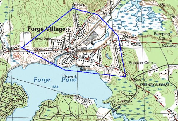
Forge Village Historic District Sketch Map North toward top
Parker Village Historic District
Description
Introduction
Parker Village (also called Parkerville) developed in the Colonial Period as a farming neighborhood, settled in part by members of the Parker family who came from Westford’s parent town of Chelmsford. The district comprises approximately 33 acres of fields, forest and residential yards. It is bounded on the east by the 1787 Parker Village Schoolhouse at 2 Griffin Road (MHC 125) and on the west by the Balch house at 246 Concord Road (MHC 126). Concord and Carlisle Roads form the principal east-west axis of the agricultural district. A triangular lobe expands the area to the north via the western end of Old Lowell Road. Topographical relief is minimal, providing expansive views across fields planted in hay. Architectural resources include 9 historic residences and two former schoolhouses from the Federal and Late Industrial Periods. Five modern houses also exist. Four former farmhouses have associated barns.
Architectural styles include Federal, Victorian Eclectic, Colonial Revival, Bungalow and Cape Cod. Buildings are located on parcels from one-half to six acres and are primarily wood-framed, although two brick examples exist. Some synthetic materials, such as asbestos and vinyl clapboards have been applied to historic buildings. The Colonial Period Pioneer Burial Ground, containing seven grave markers, occupies the corner of Old Lowell and Carlisle Roads. An historic granite signpost, minus the actual signboard, survives at the corner of Concord and Carlisle Roads. Stone walls and post and rail fences line some edges of the roads and fields. Resources are scattered among farm fields along the 3/4-mile Concord/Carlisle Road corridor which corresponds to a segment of State Route 225. The segment of Old Lowell Road in the district is a less busy, narrower road lined with prominent stone walls. At least two of the historic architectural resources, 253 and 254 Concord Road, have been altered with structural additions and the addition of vinyl siding. Three barns were demolished during the 20th century. The village retains integrity of design, feeling, association, materials and workmanship which makes this one of the town’s best preserved agricultural districts, in contrast to the Graniteville, Forge Village and Brookside industrial districts and the residential and civic district of Westford Center.
Architectural Resources
The oldest building in Parker Village is the Federal style Parker Village Schoolhouse #1 (MHC 125), located on the corner of Carlisle Road and Griffin Road. Built around 1787 of brick and wood, the former school retains much of its original design intent. It was the subject of a restoration in the early 1990s. The main block, which faces Carlisle Road, is a front-gabled, one and one-half-story, two by two-bay form with a hipped porch attached to the facade. The upper floor is enlarged by a pair of gabled dormers. Windows are primarily 2/2 double-hung sash with some 6/6 sash. Decorative elements include the molded piers supporting the front porch and molded cornice at the eave. The main block is built of brick with wood-framed gable ends clad in wood clapboards. The roof is asphalt shingles and the foundation is cut granite. The plan of the main block is expanded by a rear ell of one story that extends along Griffin Road. The ell is wood construction clad in wood clapboards. A brick chimney rises from the roof ridge of the ell. Windows in the ell are 2/2 double-hung sash with at least one example of a modern 8/8 sash. The attached one and one-half-story barn is built perpendicular to the main block and the ell. The barn is clad in wood shingles laid in stagger-butt pattern. Windows in the facade of the barn are 4/4 double-hung sash. A vehicle door and hay mow door fill the other openings.
The former schoolhouse has been in use as a residence, possibly since the 18th century and certainly sine the 19th. A low stone retaining wall lines the property’s front and east side yards. The building is well maintained.
The Wayland Balch House at 246 Concord Road (MHC 126) was built of brick with elements of the Federal style around 1810. It is a five by one-bay, side-gabled, two and one-half-story building with a two and one-half-story perpendicular ell at the west side that creates an L-shaped plan. One-story, wood-framed ells are attached to the west and north (rear) elevations. Two garage doors fill openings in the shed-roofed west side ell. The north ell is lit by a band of double-hung sash. The L-shaped main block is built of brick with wood trim at the cornice and window sills. Cut granite lintels are over the first story windows and center entry. Windows in the facade have 6/6 double-hung sash. The window over the front entry is enlarged with sidelights, as are those in the east and west side walls. Decorative elements consist of the symmetrical fenestration pattern on the facade, granite lintels, the shallow molded cornice at the eave and sidelights at the front entry. The foundation is built of cut granite and the roof is clad in asphalt shingle. Brick chimneys rise from the west side of the roof and the rear (north) ell. The detached barn in the back yard is a front gambrel form, clad in wood clapboards, built in the early 20th century. The facade, which resembles the barn at 76 Carlisle Road, is two and one-half stories in height with access to the ground floor through a vehicle door. Other openings are filled with double-hung sash. The house is well maintained and is a significant architectural component of the district.
The James Madison Parker House at 85 Carlisle Road is a Victorian Eclectic style residence built around 1850. The main block of the house comprises the western segment of the facade. This is a front-gabled, one and one-half-story, three by two-bay form with a hipped porch covering the side-hall entry. A brick chimney rises from the roofline of the western block. A side-gabled ell of one story expands the plan to the east and is accessed by a door with a modern triangular hood. The ell connects to a one and one-half-story, front-gabled barn with a rolling vehicle door on the ground floor and fixed sash in the gable peak. The front-gabled barn is enlarged at the east by a second attached side-gabled barn, also of one and one-half stories. Swinging doors give access to the interior. The entire building is clad in wood clapboards. Windows have all been replaced with modern 1/1 double-hung sash. Ornament consists of the gable returns, pilasters and molded trim in the front gabled house and barn. Additional brick chimneys rise from the roofs of the ell and second barn. The house is well maintained and retains its original form.
The ca. 1850 Victorian Eclectic style farmhouse at 254 Concord Road is a side-gabled, two and one-half story, five by one-bay form with a perpendicular rear addition and an ell built on the east elevation parallel to the main block. The house is distinguished by its rhythmic fenestration and recessed center entry with sidelights and cornice. Windows have 2/2 and 2/1 double-hung sash. Walls are clad in vinyl clapboards, the roof in asphalt shingles and the foundation is built of cut granite. Brick chimneys rise from the west elevation and from the roof ridge of the ell. The ell is one and one-half story with frieze windows along the front elevation. No frieze or other evidence of Greek Revival style detail is in existence, although these windows may indicate an earlier construction date for this portion of the house. A two and one-half-story, front-gabled barn was attached to the east wall of the ell until structural deterioration forced its demolition in ca. 1995. A detached shed exists east of the house near the road. It is a one story, side-gabled form, built in the early 20th century. Exterior walls are clad in wood clapboards. A single door and two double-hung windows light the south elevation and a vehicle door gives access on the west. The shed is similar in form to the one at 76 Carlisle Road. The house and shed are in fair condition.
The house at 253 Concord Road is a Victorian Eclectic style residence with modern additions. The historic front-gabled, three by two-bay form, built around 1865, is two and one-half stories high. Access is through the recessed side-hall entry. Windows are 6/6 double-hung sash. Decorative elements on the facade include the gable returns, corner pilasters and a molded cornice. The two-story, side-gabled addition at the east elevation, with columns supporting the integral porch, was added in 1969. The two and one-half story addition in the rear was added in the 1990s. The house is clad in wood clapboards, the roof in asphalt shingles and the foundation is built of cut granite and concrete. Stone walls exist in the side and back yards to separate the property from surrounding farm fields. While the house has been enlarged significantly during the Modern Period, the Victorian Eclectic style block retains its design integrity. Like the house across the street at 254 Concord Road, this house had a barn attached to its east side. It was destroyed in the September 1938 hurricane according to a former owner.
The Otis Parker Farmhouse at 76 Carlisle Road is a ca. 1870 Victorian Eclectic style residence with a large attached barn. The main block of the house is a front-gabled, two-story, three by three-bay form with a side-hall entry on the east side of the facade. Walls are clad in wood clapboards, the roof in asphalt shingles and the foundation is built of cut granite. Ornament includes the corner pilasters, molded cornice and recessed entry with sidelights. Windows are 6/6 double-hung sash. A one-story, side-gabled ell expands the plan to the east. Little architectural detail ornaments this portion of the house. Gabled and shed-roofed dormers enlarge the ell and a shed-roofed porch covers a secondary entry. The east end of the ell attaches to the three-story front gambrel barn, clad in novelty board. Openings in the barn facade, which is similar in form to the barn at 246 Concord Road, contain rolling doors and fixed barn-type sash on the ground floor. Fixed and double hung sash fill the openings above. A detached shed built in the early 20th century, located in front of the barn near the street, is a front-gabled, one-story form with swinging doors to access the interior. The side elevations of the shed are lit by fixed sash and the foundation is built of concrete. The shed is similar in form to the one at 254 Concord Road. A post and rail fence lines the front yard. The house, barn and shed are well maintained and contribute a great deal to the agricultural appearance of the neighborhood.
The Parker Village Schoolhouse #2 (MHC 110) is a one and one-half-story, three by four-bay, front-gabled form built in 1880 in the Victorian Eclectic style. It is rectangular in form with a one-story ell at the southeast elevation. A one-story hipped porch, supported by four posts with decorative brackets, is attached to the facade. The building is sided with wood clapboard, the roof is sheathed in asphalt shingles and the foundation is built of cut granite. Ornament at the eaves consists of a frieze and short gable returns. Wall trim takes the form of wood quoins. Four 6/6 double-hung sash on the side walls are trimmed with flat hood moldings. An entry is located at each side of the facade with a double-hung sash between. A recessed panel with flat hood molding is located at the center of the gable at the second story. A brick chimney is attached to the rear elevation and a metal ventilator with pyramidal hipped roof is at the center of the ridgeline. A fence of granite posts and wood rails lines the parking lot at the street. The building was restored as a schoolhouse museum in the mid 1990s and remains in excellent condition. Its site at the corner of Carlisle and Concord Roads is a prominent one in the district.
The Bungalow at 78 Carlisle Road was built around 1930. It is a one-story ridge-hipped form with ells at both the east and west elevations. Exterior walls are clad in wood shingles. Windows are modern vinyl sash. The foundation is concrete. A single brick chimney rises from the roofline. The moderately well-maintained house is shielded from view by the dense growth of lilacs.
The house at 66 Carlisle Road is a two and one-half-story, side-gabled Colonial Revival style design from the 1940s. The Cape Cod house at 257 Concord Road was also built around this time.
Other Resources
The Pioneer Cemetery is located at the southwest corner of Carlisle and Old Lowell Roads and occupies approximately 500 square feet. It comprises seven unmarked stones, two ornamental hemlock trees, a flagpole and stone walls at the edges. A sign reads “Early 1700s Burying Ground Here lies buried members of the Parker & Corey families, James Symons, an Indian, and other early settlers.” The stones are arranged in two short rows with mounds of moss-covered earth between.
At the corner of Concord and Carlisle Roads is a ten-foot granite post formerly used as a signpost. Bolts to hold the sign remain but no sign is in evidence. Other granite resources include the many stone walls built of fieldstone that line Concord, Carlisle and Old Lowell roads throughout the district. Walls on Old Lowell road contributed to its being designated a Scenic Road by the town.
Conclusion
The landscape of Parker Village continues to bear evidence of its agricultural past. Rolling green expanses of hay fields surround the 19th century former agricultural residences. Post and rail fences accompany some stone walls along the field edges. Horses continue to graze in fields on Carlisle Road and Old Lowell Road. The most significant change in Parker Village in the 20th century has been the cessation of almost all farm activity. No cows, chickens, hogs or apples are raised in the district today although hay baling continues. Other changes include the construction of 6 non-agricultural residences since 1950. The loss in the mid 1990s of the large barn at 254 Concord Road signifies the challenges facing farm owners in this increasingly suburban town.
Statement of Significance
The Parker Village Historic district is eligible for the National Register of Historic Places at the local level. It meets criterion A for its association with trends in agriculture, crop production and raising livestock from the 17th through the 20th centuries. The district meets criterion C for its embodiment of distinctive design characteristics visible in the simple Federal style brick buildings and the Victorian style elements ornamenting wood-framed buildings. Surviving landscape components such as farm fields and stone walls reinforce the historic appearance. The period of significance begins in 1663 with the completion of the road from Chelmsford to Groton that later became the Concord/Carlisle Road segment in the district. The period ends with the transformation of Parker Village in the mid 20th century from an agriculture-based village economy to a residential node on the modern commuter route toward Boston.
Introduction
Parker Village, located about one mile south of the Westford Center Historic District, was settled in the 17th century by members of the Parker family who migrated to the district from Woburn via Chelmsford, Westford’s parent town. Other Chelmsford residents occupied the vicinity as well, generating a population of approximately five families in the mid 18th century. At that time, according to the 1883 town history, the area was called Nonesuch after the brook by that name (the name of the brook also appears as Nonset). Population increased to around 9 families by the mid 19th century, at least four of which were named Parker. Nearly all residents were involved full time in agriculture while a small number of others adopted work such as butchering and trading.
While it lacked industrial or commercial resources, the neighborhood was typical of other farm villages in the town and region. Early settlers occupied themselves by raising subsistence crops in kitchen gardens, corn and oats for human and livestock consumption and by growing regional cash crops such as fruits, particularly apples for cider. The Framingham and Lowell Railroad maintained a station on their right of way one mile to the east at the corner of Acton and Carlisle Roads. Like other sections of the town, residents were almost entirely of English descent until the mid 1800s when Irish immigrants began to arrive.
Population of the district remained between five and ten families from the Colonial through the Industrial Period. By 1895, however, Louisa was the only landowner named Parker who resided in the village according to property valuations. Agricultural activities continued here until the 1970s when the farm at 254 Concord Road was populated with chickens, dairy cows, horses, and pigs. Hay baling operations continue in the fields.
First Settlement and Colonial Periods 1620-1775
The District was located along the route from Chelmsford to Groton that was laid out in 1663 according to Chelmsford town records quoted in the 1883 Westford town history. This is now part of Old Lowell, Griffin, Carlisle and Concord Roads, segments of which comprise the southern linear section of the district. In 1722-26, Old Lowell Road was extended west to Concord Road, forming the northwest triangular lobe of the district. No buildings survive from the First Settlement Period. Genealogical information notes that Aaron Parker (1689-1772) was the first member of his family to live in Westford. He had a farm on Old Lowell Road ¼ mile east of the current district boundary. He and his wife Abigail Adams Parker had 10 children, five of whom probably remained in the town during the Colonial Period.
According to historical geographer Douglas R. McManis, food items consumed by New England colonists consisted mainly of corn, wheat, rye, barley, peas and other kitchen garden items such as onions, turnips, carrots, cabbage, fruits and herbs. These items were in addition to the staples of pork and beef. Oats are listed as typical Colonial Period animal fodder. These foodstuffs correspond to census information specific to Parker Village in the 19th century, suggesting diets and crops of area farmers changed little over that time. McManis also indicates that pork-packing became an important industry soon after initial settlement and, in Parker Village, may have endured into the 19th century when a resident was specified as a butcher in the 1865 state census.
According to the map printed in the 1883 town history and purporting to depict Westford in 1730, a house was located within the triangle of land formed by Old Lowell, Carlisle and Concord Roads. This is not the existing house at 254 Concord Road but an earlier home occupied by Samuel Chamberlain (1689-1769) according to the historical notes written by 19th century Parker Village resident May Balch and by Edwin Ruthven Hodgman, 19th century town historian and minister. Mr. Chamberlain, an original First Parish Church member in 1727 and selectman in 1730, at one time owned most of the land in Parker Village. The appearance of his house and its time of demolition are not known. The former Proctor Farm near the site of 76 Carlisle Road is also represented on the map in the town history. This house is depicted in a ca. 1900 photo as a Colonial style, side gabled, two and one-half-story form of five by three bays. Notes with the photo cite a ca. 1700 construction date and state that it was destroyed by fire in 1916. Another house was located at the east end of the district and occupied by three generations of the Minot family. Jonathan (b. ca. 1700) and Elizabeth Minot had grandchildren who attended Harvard University and who served in the Revolutionary War. Their farm and garrison, described as a “big house and barn with a double walled room for protection against Indian raids”, was built in 1723 according to a 1913 local news article quoted in Westford Days. This later became the farm of Gilbert Parker (b. 1796) in the 1820s and burned in 1913. A ca. 1900 photograph depicts a two and one-half-story, three-bay, side-gabled Colonial form with a center brick chimney and two large detached barns. Historic photos of the demolished farms indicate the existence of an architectural form with design characteristics that continued to be built from the Colonial Period through the Early Industrial Period.
The Pioneer Cemetery at the southeast corner of Old Lowell and Carlisle Roads may have been created during the Colonial Period as a small family plot according to a mid-20th century local historian. May Balch, resident of the district until 1897, wrote in 1952 that the cemetery was established “in the early days” of Parker Village history well before her childhood in the 1870s-80s. No inscriptions or official written records exist concerning the burials. Legend states there is a married couple buried here and a stone marking the burial of a person’s arm.
Federal Period 1775-1830
Unlike the densely settled village of Westford Center (MHC Area D) with its commercial and civic activities, or the developing mill villages of Forge Village (MHC Area E) and Graniteville (MHC Area F), Parker Village experienced only scattered residential and agricultural development during the period. Nine farmhouses were spread along ¾ mile of road, an arrangement that was typical for much of the town. The 1787 Parker Village Schoolhouse #1 (MHC 125) on the Groton to Concord Road, also called the Boston Road, (now the corner of Carlisle and Griffin Roads) provided a focus for the linear farming district. This may have been built as a residence for Aaron Parker and used simultaneously for a school. Local historians indicate the brick for the school was fired on Brickyard Hill, one half-mile north of the district. Information from the 1790 federal census indicates six Parker households with a total of 34 family members in the entire town, although only around four of these families lived in the village. The 1830 federal census also lists four Parker households. Other families such as the Minots and Chamberlains continued to reside here.
The 1795 series map depicts in Parker Village the “Road from Groton to Concord” (now State Route 225) and the Road from “Westford to Concord” (now Carlisle Road). The current Old Lowell Road, now one of four Westford Scenic Roads, is not shown although it did exist as a narrow lane (it is still narrower and less traveled than the other two roads). No buildings or industrial installations are noted on the map within the village although there were four houses and associated farm buildings from the previous period. Federal Period development in Parker Village consisted of
the construction of the 1787 Parker Village Schoolhouse #1 at 2 Griffin Road (MHC 125) and the ca. 1810 brick farm house at 246 Concord Road (MHC 126). The schoolhouse was one of four built by the town in that year. The farm house was probably built for Timothy Prescott (b. 1755) who lived here until 1825 when he sold to the farmer George Fletcher (b. 1798). Mr. Fletcher and his descendants occupied the house for over 50 years. A ca. 1900 photograph shows a detached barn in the back yard built perpendicular to the existing barn that later replaced it. The form and condition of the exterior of the older barn indicates it was probably built during the Federal Period. It was demolished or burned in the 20th century. The house and school are the only two surviving examples of brick construction in the district. The brick came from a kiln on what was locally known as Brickyard Hill, located ½ mile north of the district.
Brick construction is rare in the town. In the district of Parker Village there are two examples that both have Federal Period construction dates which indicates a relatively high frequency of brick in a small geographical area and short time span. A brickyard is mentioned in town histories as having existed on Carlisle Road near the former Wilson Farm but little more is known about it. Occurrence of the distinctive building material, while apparent in isolated residential examples elsewhere in Westford, distinguishes the village from others in the town.
Early Industrial Period 1830-1870
No changes to the transportation routes occurred during the period. Concord/Carlisle Road (SR 225) continued to form the southern edge of the district and a segment of Old Lowell Road the northern boundary. The number of residences increased from 5 in 1830 to 9 in 1870 according to historic maps. In 1830, the village consisted of the brick farmhouse at 246 Concord Road (MHC 126) and the C. C. Derby, Samuel Chamberlain, Jonathan Minot and Proctor Houses, the last four of which have been demolished or removed. By 1870, historic maps indicate the addition of the houses at 253 and 254 Concord Road, 85 Carlisle Road and a house now removed near 78 Carlisle Road. The 1787 Parker Village Schoolhouse #1 (MHC 125) remained in use as a school.
Federal census information from 1850 enumerates at least four Parker households and three other families. George Kidder, Nahum Conant, Asa Parline, as well as Gilbert, James M., George A. and Thomas J. Parker all were heads of families in the village according to the 1850 census. Several employed non-family members as hired hands. The state census from both 1855 and 1865 list two households in or near the district that contained Irish-born residents. In 1855, the O’Connors and Gallaghers lived in or near the district and included eight Irish-born residents. In 1865, the O’Toole and McEllacott (also McElligott) families resided between the Temple house on Texas Road, located south of the district and the Minot house (burned in 1913) at the east end of the district. These immigrant families’ homes are not depicted on historic maps and may have been overlooked by 1855 mapmaker Edward Symmes although some do appear as property owners in later tax valuations.
Like most of the town of Westford, the economy of Parker Village was based on agriculture. Residents were farmers except for George A. Parker, a butcher who lived near 76 Carlisle Road and his brother James Madison Parker, occupant of 85 Carlisle Road, who was a trader of unspecified variety. Both were listed as such in the 1865 state census but engaged in some crop raising as well. Nahum Conant was listed as a cooper in the 1850 federal census. George Kidder, resident of 253 Concord Road was typical of Parker Village farmers at that time. He was taxed in 1860 for raising two dairy cows, three horses and two oxen on 67 1/2 acres of meadow and fields. Crops and produce at the Kidder farm included corn, oats, peas and beans, Irish (as opposed to sweet) potatoes, butter, hay and slaughtered animals. These items were typical for the district with some residents engaging in raising orchards, making cheese and raising market garden crops. After the arrival of the Framingham and Lowell Railroad with a station one mile to the east, milk production among the villagers increased drastically. George Fletcher, a more successful farmer, occupied the house at 246 Concord Road (MHC 126). He owned 142 acres, two oxen, two cows and seven horses. The wealthiest resident of the village was Gilbert Parker, father of George A. and James M. Parker, who occupied the Minot Farm until his death in 1874. In 1860 Mr. Parker owned 215 acres, two oxen, seven cows, three horses, stock in two railroads and had money at interest. His estate was comparable to the town doctor and other wealthy residents of affluent Westford Center (MHC Area D). The member of the neighborhood with the lowest property valuation was the trader James Madison Parker who lived at 85 Carlisle Road, and owned nine acres.
Architecture from the Early Industrial Period includes the Victorian Eclectic style farms at 253 Concord Road, 254
Concord Road and 85 Carlisle Road,
all built between 1840-1855. Barns were
built with all these homes although the only example to escape demolition is at
85 Carlisle Road.
Wood-framed construction of
farmhouses in the Victorian Eclectic style was common in the agricultural town
of Westford and historic examples survive in most areas. Parker Village’s Early Industrial
architecture is representative of these period resources and are more well
preserved than others in the town in terms of materials, design and setting.
Late Industrial Period 1870-1915
The transportation network in Parker Village was complete by 1870. The 1875 county atlas indicates that a dirt lane led south from the intersection of Carlisle and Concord Roads to a farm field. The lane is still in existence, used in part as a driveway for the house at 77 Carlisle Road. The granite signpost at the corner of Carlisle and Concord Roads was erected during this period. The town began maintaining “guide boards” or road signs in the 1890s.
The population of Parker Village did not change significantly from the Early to Late Industrial Periods. Nine houses and the schoolhouse existed within the district in 1870. One new house, 76 Carlisle Road, was built between 1870 and 1915. The 1889 Walker map also depicts a residence, about which little is known, west of the house at 253 Concord Road. It has since been demolished or removed. In 1874, the town built a new district schoolhouse ¼ mile west of the 1787 Parker Village Schoolhouse #1 (MHC 125). The new schoolhouse burned in 1880 and was replaced in that year with the existing Parker Village Schoolhouse #2 (MHC 110) at the corner of Carlisle and Concord Roads. According to annual town reports, the architect for the new school was E. A. Stevens and the builder was Jonathan Larcom. Also, local historians believe the foundation as well as some windows and doors from the burned building were reused. A well was dug for the schoolhouse in 1884. George A. Parker bought the 1787 schoolhouse in 1874 and may have used it to house his butcher shop. C. H. Keyes owned the former school in 1889. For a short period in the late 1890s, the former school functioned as a meeting and dance hall. The So. Westford Social Club met here in 1896 and 1897 for whist games, violin music, dancing, refreshments and sleigh rides. Activities of the club are described in weekly notes or meeting minutes kept by May Balch, resident of 246 Concord Road.
Economic activity continued to be based almost completely on farming with some small non-agricultural operations. For example, in 1885, the owner of the farm at 246 Concord Road, Wayland Balch, paid tax on a shop of unspecified nature. Also, the town road and bridge report for that year lists Mr. Balch as being paid to repair Brickyard Hill Road, reference to a supplemental means of income and to industrial activity carried on just north of the district. Taxable crops commonly consisted of corn, apples and hay. Local residents recall picking berries, several varieties of fruits and at least one Westford resident outside Parker Village was assessed for ownership of a vineyard suggesting additional depth to the types of crops grown in town. Other crops were surely grown but did not appear in valuations. Westford Grange #208 was formed in 1895 and met in Westford Center.
Architecture from the Late Industrial Period includes the Otis W. Parker Farm at 76 Carlisle Road. The most ornate part of the house is the western end of the building, which has Victorian Eclectic style architectural detail, although the barn’s front-gambrel form appears to have been built early in the 20th century.
The Otis Parker Farm and the Parker Village Schoolhouse #2 are indicative of the wood-framed methods of construction and Victorian style design characteristics in existence throughout the town. A significant loss in terms of architecture was the ca. 1723 Minot Farm formerly located at the corner of Texas and Carlisle Roads across from 85 Carlisle Road. A 1913 news article in the Westford Wardsman laments at some length the destruction by fire of what may have been a garrison with hidden interior chambers for defense from Native Americans.
Modern Period 1915-1965
At the beginning of the Modern Period, the economy of Parker Village was an agriculture-based system composed of small farms raising hay, corn, dairy cows, apples, chickens and produce for local consumption. By the mid 20th century, the district had changed to a suburban neighborhood of residents who commuted to jobs outside the area. Indicative of changes in the economy of the district was the demolition of the large chestnut framed attached barn at 254 Concord Road. Used to house cows and hay until approximately 1980, the barn deteriorated to the point where it could no longer be safely occupied and was taken down in 1995. The hurricane of September, 1938 destroyed the barn at 253 Concord Road according to a former owner. The Colonial Period Proctor Farm that was built near the site of 76 Carlisle Road in ca. 1700 burned in 1916 according to a contemporary news account. The schoolhouse at the corner of Carlisle and Concord Roads remained in use until 1928 when the district primary schools were consolidated in Westford Center (MHC Area D). The building was later used as a clubhouse. In recent years, it has been renovated and used as a living classroom of the early 20th century, attended by all Westford third graders, and as a meeting place for scouts and other community organizations. Concord Road was called Boston Road until the 1930s, indicating its vestigial importance as a through travel route.
Buildings that were constructed during the period include the Cape Cod house and attached garage at 257 Concord Road. The house at 66 Carlisle Road was built ca. 1940. Houses at 68, 77, 80 and 81 Carlisle Road and 2 Old Lowell Road were built between 1960 and 1990.
Conclusion
The historical appearance and associations of Parker Village remain intact by virtue of its surviving fields and former farm houses. While some historic buildings have been altered, many continue to bear the exterior materials and architectural design elements of the original construction. The Pioneer Cemetery serves as the final resting place for early settlers of the area. Some new construction has occurred but not to the extreme detriment of the existing historic fabric. Perhaps the most evocative surviving components of the village’s past are the fields and stone walls that line the sides of Concord, Carlisle and Old Lowell Roads throughout the district and the Parker Village district school house which serves as a living museum and also still serves as a focal point for local events.
Geographical Data
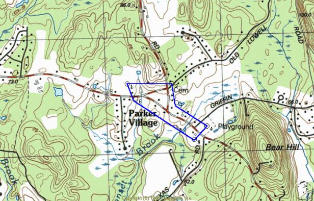
Sketch Map North Toward Top
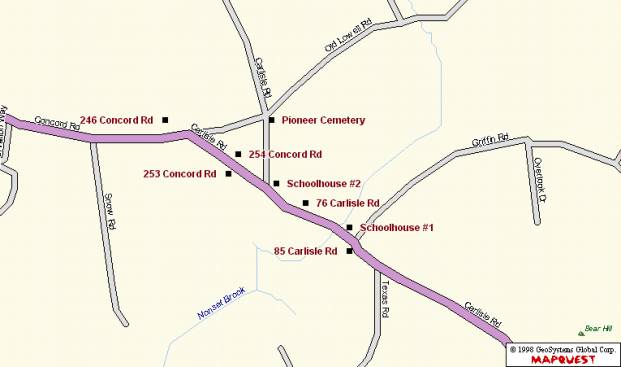
Sketch Map North Toward Top
Verbal Boundary Description
The Parker Village Historic District is comprised of segments of three roads: Concord Road from the house at 246 Concord Road to its terminus at the junction of Carlisle Road; Carlisle Road from the corner of Old Lowell Road to the house at 85 Carlisle Road; Old Lowell Road from Carlisle Road to Concord Road. The boundaries encompass approximately 33 acres on which are located historic former farmhouses, barns, two former schoolhouses, a cemetery and a signpost.
Boundary Justification
The boundaries of the Parker Village Historic District were selected for their demarcation of the limits of the historic resources of the village. Beyond the boundaries are increasing numbers of modern residences and less frequent evidence of the area’s agricultural past. The examples of agricultural landscapes with associated residences on Concord, Carlisle and Old Lowell Roads retain integrity of materials, design and setting. The former J. M. Parker farmhouse and barns as well as the 1787 District No. 5 Schoolhouse mark the eastern boundary of the district. The Wayland Balch house is one of a small number of remaining Federal Period Brick houses in the town and marks the western boundary of the district. Resources between are arranged largely in linear fashion and include additional residences, barns and stone walls, school houses, an historic granite signpost and a Colonial Period burial ground at the northeast corner.
Brookside Historic District
Description
Introduction
Brookside is a former mill village of 25 historic resources, including the former Brookside Woolen Mill, multiple unit worker housing, single unit residences, a granite dam, a bridge and five examples of modern construction. Buildings are Colonial, Greek Revival, Queen Anne, Victorian Eclectic and Colonial Revival in style and are in poor to good condition. The moderately dense linear area includes resources on Brookside Road between Lowell Road and Coolidge Avenue. Four additional resources are located on Moore Road and Coolidge Avenue. Stony Brook traverses the center of the area along the right of way of the CSX Railroad, both of which are perpendicular to Brookside Road. Brookside complements Westford’s other mill villages, Graniteville and Forge Village which are much larger, each containing hundreds of historic resources. Brookside was owned in the late 19th and early 20th century by Chelmsford industrialist George C. Moore who was responsible for much of the industrial development. It was subsequently operated by Abbot Worsted Company, which also operated mills in forge Village and Graniteville. A railroad depot existed until the mid 20th century but has been demolished. Other large brick industrial buildings have also been demolished, although the principal mill building and its prominent tower survive. Despite some changes, the Brookside Historic District retains integrity of design, feeling, association, materials and workmanship.
Brookside Mill
The two-story Brookside Mill on Brookside road is built primarily of brick with some granite ashlar construction in its older sections and some more recent cinderblock additions on the south side of the complex. The existing plan of the mill has evolved to the point where it is nearly square. The oldest section, built of granite around 1862, is a rectangular form oriented largely east-west and measuring approximately 30’ x 85’. An 1894 addition, measuring 40’ x 50’, was made perpendicular to the east end of the granite block and expands the plan to the north. Also in 1894, the main mill measuring 150’ x 60’ was built parallel to the 1862 mill, resulting in a reversed Z-shaped plan. A wing projected to the east from the central stem of the Z plan, creating a courtyard between it and the main mill. The courtyard formerly contained a square smokestack built of brick that has been demolished. The courtyard has been roofed and enclosed and the east end of the 1862 mill has been extended toward Brookside Road. The enclosure of the courtyard and additions to the 1862 mill have altered the appearance of the complex from that of a series of brick and stone buildings joined around a central smokestack to a single block of amalgamated subparts.
The main component of the Brookside Mill is the 1894 brick, two-story, flat roofed 150’ x 60’ section located immediately south of Stony Brook and west of Brookside Road. The eight-bay, easterly-oriented facade is interrupted by additions of cinderblock and brick. The north- or stream-side elevation of the building is an unbroken brick expanse of 19 bays which, by virtue of the long row of arch-topped window openings and the lack of modern construction, is most evocative of the mill’s former appearance. The brick section of the mill is anchored at its northeast corner by a three-story brick tower with arch-topped windows, many of which have been bricked in. The tower is depicted in an historic engraving with a pyramidal roofed belfry that has since been lost. The belfry had jigsawn brackets supporting the corner posts and a patterned shingle roof. Windows that remain uncovered are 12/12 double-hung sash. Ornament consists of jigsawn eave brackets. Foundation material is primarily cut granite with some brick. A wood-framed shaft, approximately eight feet on a side, is clad in wood clapboards and rises two stories along the west wall of the mill.
The central, older section of the mill was built around 1862 of granite random-laid ashlar. This section, located south and west of the larger brick section, is also two stories and approximately six by four bays. As in the larger brick section, arched openings here are filled with cinderblock, plywood and brick. Ornament on the granite mill consists of heavy wooden brackets, a brick corbel at the eaves and brick vussoirs in the window arches. The brick and stone sections of the mill are joined at a vertical section of overlapping brick and granite masonry visible on the south elevation. The granite mill, while partially visible from both sides, is shielded in some places by modern wood and cinderblock additions. Modern additions and the deteriorated state have left the granite mill in poor condition.
Construction of the mill consists of load bearing masonry walls with gradual-pitched gabled roof trusses built of wood. Trusses in some places had been supported in the center by rows of wood piers. These piers were modified in the 20th century to accommodate forklift traffic. The piers were cut three feet below the ceiling and at the floor level and removed. Their load-bearing potential was replaced by steel turnbuckles attached to exterior walls and slung under the piers’ remaining three-foot upper sections. Window sills are granite in many places. Floors are wood plank, several layers thick.
The stream on the north side of the building is the site of the granite dam, the bridge carrying Brookside Road over Stony Brook and the water intake or penstock for the turbine formerly located in the lower level of the mill. The ten-foot high dam is attached at its south side to the mill foundation and extends forty feet north across Stony Brook. A granite block wall eight to 15 feet in height lines the north bank of the brook. Water level was regulated by a control gate or sluiceway in a broad notch in the top masonry course of the dam. Secondary outlets for water flow are located on the north side of the dam, consisting of three-foot diameter iron pipes. Historically the dam impounded a pond of several acres that concealed much of the stone construction described above. Twenty-foot wide Stony Brook now flows through the center of the former pond bed.
Downstream of the dam is the bridge over Stony Brook. Three flat arches, also built of random ashlar, carry the road over the stream bed. Each arch spans approximately 10’ while the entire bridge extends for nearly 100’, including piers, spandrels and abutments. An additional pair of three-foot diameter iron pipes also conduct water under the bridge.
The penstock, conducting water from stream bed to mill, is a five-foot diameter iron pipe. Water enters the upstream opening, is forced to the right (south) by a 90-degree bend in the intake pipe, which then enters the lower level of the mill tower where it formerly turned the turbine rotor. Nothing remains of the water powered mechanical system inside the building. Water currently enters the base of the tower through the penstock and exits the building through the subterranean brick vaulted tailrace that leads under Brookside Road and back into Stony Brook.
The H. E. Fletcher Social and Athletic Club at 11 Brookside Road was built in 1920 in the English Revival style as the “Brookside Lunch”, a dining hall for employees of the Abbot Worsted Company. The building is a side-gabled form of one and one-half stories with an enclosed entry porch and gabled dormers on the front slope of the roof. A rear ell expands the plan to the east. A secondary entry on the south elevation is covered by a shed-roofed porch. The exterior, labeled as plaster on architects’ plans, is now clad in vinyl clapboards. Windows are modern replacements and are smaller than the original 6/6 double-hung sash. The building is sited behind a cut granite retaining wall and is in fair condition.
During the 1970s, the mill owner built a large metal-clad refrigeration facility south of the mill. It has a low-pitched gabled roof and occupies the rear of the parking lot behind the mill. The building is a featureless, windowless mass separated from the mill by an expanse of asphalt paving.
The Brookside Mill is the smallest of Westford’s principal historic industrial facilities. Others in Forge Village and Graniteville are older, retain more architectural integrity and display a wider variety of design elements. However, the Brookside Mill continues to represent a significant historic entity that gives a sense of place the village of Brookside. Its brick construction with Victorian details and the associated water-power structures, and its association with the Abbot Worsted Company, distinguish it as an important component of the town’s industrial history.
Residential Architecture
The neighborhood surrounding the mill bears indications of its former status as a mill village. The likely home of Colonial Period miller William Chandler, built ca. 1725 at 20 Brookside Road (MHC #116) is a side-gabled Colonial style building of two and one-half stories and five by one bay. The house is sided in wood clapboard and the roof is sheathed in asphalt shingles. The center entry has a Federal style surround with sidelights and entablature. Windows are 2/2 double-hung sash with plain trim. A brick chimney occupies the ridge of the roof. The detached garage is a front gambrel, two-bay form located west of the well-maintained house. The Chandler House is typical of 18th century homes in the town. Houses with historic wood clapboard exteriors, Colonial style side-gabled forms, and classical entry surrounds are found in most parts of Westford and identify the area as a place of Colonial Period settlement.
The Greek Revival style house at 9 Brookside Road, built in 1862, is a front-gabled three by two-bay form of two stories. A one-story ell expands the plan to the south. Windows and siding are modern replacements. The recessed side hall entry retains its wide trim and sidelights. Other ornamental features include the molded cornice and gable returns. A one-story bay window lights the south elevation next to a shed porch in the ell. The house is in fair condition.
A Victorian Eclectic style tenement with paired front doors exists across the stream to the north at 5 Moore Road (MHC 17). The ca. 1870 house is a 6x2-bay, side-gabled form of two and one-half stories that overlooks the mill from its hillside location. A two-story addition has been made to the rear of the house. Windows are 6/6 double-hung sash with no trim due to the application of vinyl clapboards to the exterior. Ornamental features include the gable returns and molded cornice. Other exterior ornament may have been removed at the time of the re-siding. Two brick chimneys rise from the roof-peak. A modern triangular entry porch covers the central bay of the fairly well-maintained building.
The Victorian Eclectic style house at 24 Brookside Road, ca. 1880, resembles 5 Moore Road in its form but lacks the double front entry to confirm it as a double tenement. It is a five by two-bay, side-gabled form with a shed-roofed rear ell. The house, like 5 Moore Road, is located on the low hill to the north that overlooks the mill. Windows are 1/1 and 2/1 double-hung sash with no trim due to the application of vinyl clapboards. The center entry is covered by a flat roofed porch with Victorian turned columns. A granite retaining wall exists between the house and the road. The house is in fair condition.
One Brookside Road, built ca. 1890, is a side-gabled form with a Queen Anne style tower attached to the facade and an integrated shed-roofed front porch. The tower is a two-story, three-sided form with a gabled roof. Wood clapboards cover the exterior of the well-maintained house. Windows are 2/2 and 6/6 double-hung sash. A two-story addition has been made to the north side elevation and, like the main block of the house, has corner pilasters, gable returns, frieze and molded cornice.
The Victorian Eclectic style residence at 27 Brookside Road was built ca. 1890. The two-story, side-gabled five-by two-bay form is expanded with large dormers on the front slope of the roof and a hipped one-story addition on the south elevation. The roof of the house is clad in asphalt shingles, the walls in asbestos clapboards and the foundation is built of cut granite. Ornamental elements include the wide trim with entablature around the center entry, gable returns, molded cornice and hood moldings over the windows. Dormers have closed gables and paired sash. Windows are 2/2 double-hung sash. The house is in fair condition, having been altered with modern siding.
Six former mill workers’ houses, built around 1895, exist at 34-44 Brookside Road. These are identical in form except for reversals in the layout of the floor plan. They are two stories in height and three bays across the facade with a cross-hipped roof. Cut-away entry porches exist under the front eaves. Adjacent to the entry porch, facades have bays that create canted corners at the first story. Well-preserved examples in this group have wood clapboard exteriors, 6/1 double-hung sash, turned posts supporting the porches and pendants descending from the soffits of the canted corners. Some houses have been altered with the application of modern siding materials, installation of modern windows and removal of some architectural detail.
Coolidge Avenue is the location of historic residential architecture built for employees by the Abbot Worsted Company after their purchase of the mill in 1919. The single family Colonial Revival style house at 1 Coolidge Avenue is a side-gambrel, three by one-bay form of two stories built around 1936. A two-story rear ell is built perpendicular to the main block of the house. Exterior walls are clad in wood shingles, the roof in asphalt and the foundation is undetermined. Original windows have been replaced with vinyl-framed sash. Ornament on the building consists of the corbelled brick center chimney and corner boards. Gable returns, piers with molded caps, and a segmental arched ceiling ornament the gabled center entry porch. The house is in good condition. The residence at 3 Coolidge Avenue is a side gabled cottage also bearing Colonial Revival style details. It was built around 1919 for Abbot Worsted Company employees. It is built on a scale similar to its neighbor at 1 Coolidge Avenue and shares some design elements. Other such residences are scattered widely on Coolidge Avenue and other streets near the district.
The multiple unit residence at 5-7 Coolidge Avenue, also built ca. 1919, is a side-gabled, two and one-half-story, Colonial Revival style residence of five by two bays. Shed roofed enclosed porches expand the plan at both gable ends. Two entrances with classical trim fill openings in the facade. Windows are 6/6 and 8/8 double hung sash which are paired in the center bay. Exterior walls are clad in wood clapboards, the roof is clad in asphalt shingles and the foundation is built of cobblestone. The house is in good condition and bears a strong resemblance to other multiple unit residences in the mill villages of Graniteville (MHC Area F) and Forge Village (MHC Area E) where the Abbot Worsted Company also had mills and mill worker housing. The house is in good condition.
Many residences in the village of Brookside are associated with the mill and reflect characteristics common in company-designed and built houses. The similarity of form, scale and building materials identify them as part of a historic industry-based population center. The relatively high density of historic construction focused around the intersection of Stony Brook, Brookside Road and the Stony Brook Railroad are illustrative of patterns of 19th century village life.
Statement of Significance
Introduction
Brookside is the smallest of Westford’s three mill villages, located on Stony Brook 3-4 miles downstream of Forge Village and Graniteville. (MHC Areas E. F) The district is eligible for the National Register under criterion A for its association with the town’s industrial history. This was the site of a Colonial Period fulling mill, operated by William Chandler who came to what was then Chelmsford from North Andover. The tradition of manufacturing textiles, as well as milling of corn and lumber, continued at this location under the power of the flow of Stony Brook until the 20th century. Manufacturing activity encouraged the transformation of the area during the Industrial Periods from a rural hinterland into a busy mill village served by a railroad and street railway. Brookside is also eligible under criterion C for its embodiment of distinctive characteristics of the New England mill village as seen in its repetitive architectural designs for mill worker housing and in the long march of arched windows in the brick expanse of the mill building’s north wall.
Decline of manufacturing activity in the 1940s brought on
the change from industrial to residential village. Streetcar and railroad services were discontinued in the 1920s
and 1950s, respectively. Manufacturing
activity at the Brookside Mill gave way to storage in the 1960s which preceded
the abandonment of the mill building in the 1980s. The vacant state of the mill has allowed structural deterioration
to claim significant building elements such as the tower roof and nearly all
the large wood-framed sash that had not previously been replaced with brick.
Surviving elements include the granite dam, retaining walls, penstock, bridge,
lunchroom and two major historic sections of the mill building. The period of significance for the Brookside
Historic District is ca. 1725-1945.
Pre-Industrial Period
Westford's first fulling mill was located ca. 1725 near the current site of the Brookside Mill according to the 1883 town history. William Chandler is noted as having built a water powered fulling mill and grist mill which, by virtue of the powerful head of water for turning a wheel, remained in business throughout the period. The 1795 map of Westford describes both a grist mill and a fulling mill on the site. The 1917 History of Chelmsford indicates a bridge existed near Brookside by 1827. The 1831 series maps labels the site “mills” with two residences located nearby. One may have been William Chandler's former house at 20 Brookside Road (MHC 116), which continues to occupy the southwest corner of Moore and Brookside Roads. The other is 1/10 mile east of the district boundary.
Early Industrial Period 1830-1870
Members of the Adams family, millers of corn and lumber, succeeded Mr. Chandler in operating the mill at Brookside, as is reflected on the 1857 Walling map of Middlesex County. Shortly thereafter, they sold to Theodore H. Hamblett, recent owner of the saw and grist mill at Westford Depot, located upstream approximately one mile at Depot Street. Mr. Hamblett was taxed in 1860 for the mill building, water privilege and stock in trade. He also built a house nearby at 9 Brookside Road. Mr. Hamblett carried on his business with his relative W. C. Hamblett until 1862 when they sold to George R. Moore according to Stone’s History of Massachusetts Industries. George and Seth Moore transformed the product of the mill from flour and lumber to woolen yarn. The factory became part of the Moore family’s growing conglomeration of foundries, textile mills and machine shops, based in Chelmsford. The Moore’s acquisition began the period of most intense growth for the mill and for the village of Brookside. They erected in 1862 the stone building comprising the oldest existing part of the mill. George R. Moore is listed in the 1870 federal census as a 54 year old manufacturer, married to Philanda R. Moore with children George C., Edward A. and a Mary E. The Moore’s houses two non-family members, one of whom was born in England.
The Stony Brook Railroad, which opened along the stream of that name in 1848, also facilitated growth of the village of Brookside. The railroad connected the shipping and manufacturing centers of South Groton (now Ayer Center) and North Chelmsford. The company was based in Lowell and built the road primarily to ship manufactures along Stony Brook, but also offered passenger service. The railroad never owned any rolling stock (engines or cars) and was leased upon its opening by the Nashua and Lowell Railroad, a larger operation with rolling stock operating between the manufacturing centers of its name. The improved shipping opportunities provided by the railroad allowed industry on Stony Brook to grow much faster than before. Ability to transport mill products to Lowell and beyond increased appeal of the Brookside site as well as those of the Abbot and Sargent companies that were making woolen goods and wool refining machinery upstream in Forge Village and Graniteville. Mr. Moore raised the railroad right of way six feet in order to increase the level of Stony Brook and thus the power delivered to the machinery. Brookside Station, located across the brook from the mill, was a one-story, front-gabled building with Victorian details judging by the shape of the window openings in a 19th century engraving. The 1857 map shows the station sited between the railroad and the stream to the east of Brookside Road. This was moved across the street and replaced in the early 20th century by a wood-framed station with ridge-hipped roof. A side-gabled freight house occupied a site west of the station.
During the mid 19th century, mill workers in Brookside were sufficiently small in number that they did not require company-built housing. In 1855 there were three residences in the village, belonging primarily to farmers. Mrs. A. F. Dun occupied the Colonial Period Chandler House at 20 Brookside Road (MHC 116). The widow Pamelia Kendall occupied a home, now demolished, north of the mill near the corner of Moore and Brookside Roads. Ephraim Harwood (also Hayward) owned a house on Brookside Road to the south of the mill. The 1857 map shows a carriage shop to the south of Mr. Harwood’s residence.
Sometime later, Brookside Mill workers lived in the company tenement house at 5 Moore Road (MHC 17). The building was built between 1865 and 1875 and appears under the company’s ownership as the “Boarding House” in the town valuations from that year. 1870 federal census information shows that four residents with different surnames lived in a single house. These were Hannah Bocock, native of England, Alice Jackson of Massachusetts, James Hantor of Scotland and John Tague of Ireland. Additional non-native residents also occupied homes in the area. This is a high concentration of non-native births for Westford at the time.
Early Industrial Period architecture in Brookside bears a similarity to construction in Westford’s other mill villages of Forge Village and Graniteville. The random ashlar granite mill built ca. 1862 bears a strong resemblance to the Abbot Worsted Company Mill #1 in Graniteville, built to around the same size of the same material in 1858. Forge Village is the site of numerous multiple unit side-gabled dwellings with paired entries. Tenements at 8 -10 and 24-26 Bradford Street are examples of this house type although they were built some time later than the example in Brookside.
Late Industrial Period 1870-1919
The 1875 town tax valuations indicate that Seth G. Moore owned at Brookside two water-powered mills with auxiliary steam engines, a blacksmith shop and three houses. The woolen mill in 1875 consisted of the granite section in the southwest side of the existing complex along with three similar sized wood-framed mill buildings and the centrally located brick smokestack. From 1885 - 1911, Mr. Moore’s relative George Clifford Moore owned the mills and expanded them almost continually throughout the period. George C. Moore entered Westford Academy in 1863 and later became a civic-minded Chelmsford resident. He donated money to that town for the establishment of the North Chelmsford Fire District, and served as a special police officer. Mr. Moore owned many industrial operations there and made his home in the town. He added an office to the Brookside mill complex by 1885, as well as two houses for employees, a social hall, outbuildings and hundreds of acres of land, all according to tax valuations. Business records indicate he was as much a real estate trader as wool manufacturer. Credit reports compiled in the 1880s by R. G. Dun & Company note Mr. Moore as a wool washer but list mostly land transactions when describing his work. George Moore would exert his influence over the village most noticeably when, in 1894, he replaced the wood-framed mill buildings, as well as two frame store houses and waste house with the existing brick construction.
An 1890 Barlow’s Insurance Company survey lists Brookside’s principal resource at that time as the Main Mill, which is the existing central granite building. The first story was the location of combing and spinning while the second story housed picking and carding operations. These activities were carried out using Sargent’s wool picking and burring machinery which was manufactured three miles up Stony Brook in Graniteville. (MHC Area F) Other processes such as scouring and drying took place in North Chelmsford at another of Mr. Moore’s factories. Additional buildings in 1890 which no longer exist are the Wing that faced Brookside Road and housed a coal fired steam engine, looms and repair operations; the Store House for old machinery west of the mill; the Old Mill with its water wheel in the basement; Waste House, Stock House and the square smokestack. These were wood with the exception of the stack which was brick. Employees worked 60 hours per week in the steam-heated, kerosene lamp-lit mill, using both steam and water power to run machinery. By 1891, Brookside Mill employed 125 hands and manufactured 600,000 pounds of yarn a year according to Orra Stone’s 1930 History of Massachusetts Industries.
Between 1890 and 1894, a major reconstruction of the mill took place. An insurance survey from that year shows the mill closer to its current configuration. The Old Mill, Stock House and wood-framed part of the Main Mill were removed and replaced with brick construction that included the existing tower on Brookside Road and the brick block along the stream connecting to the Main Mill. Operations of the mill consisted of carding, combing, drawing and picking on the first story, spinning, twisting and weaving on the second and power generation via a Thomson Houston 110-volt dynamo in the base of the tower. The second story of the tower may have been used for offices given the presence of awnings at this location in a historic photo. (The deteriorated condition of the floor prevented physical examination.) The dynamo allowed employees to work by incandescent light. The wood-framed water-closet shaft on the west elevation of the brick mill, the stone dam, Store Houses and a Dust House were also present.
William C. Edwards, who was contracted to build the J. V. Fletcher Library in Westford Center (MHC Area D) and the Sargent School in Graniteville also built the 1894 mill building according to previous research. The Moore Company also built a new social hall near the mill pond (an unidentified predecessor of the existing 1920 hall at 11 Brookside Road). The company retained its blacksmith shop and storehouses. In 1905, Mr. Moore’s Westford business was taxed for ownership of nine houses and a boarding house in addition to his mills, among which were the old grist and saw mills, possibly still in use. Blacksmith and box shops existed to support the main industrial activities. An engraving from this period shows the mill with the existing tower as the central element in the complex. Additional surviving components are the dam, penstock, railroad and the granite bridge over Stony Brook. Elements in the engraving no longer standing include the two-story, low-pitched gable-roofed storage building east of Brookside Road and two additional flat-roofed buildings south of the primary building. Standing among the mills in the image is the brick smokestack that has also been demolished.
George C. Moore built six single-family workers’ cottages on Brookside Road by 1895. This group of identical homes survives ¼ mile north of the mill. The houses are described in tax valuations as “new cottages, Nos. 1,2,3,4,5 and 6, $900 each”. (MHC Area G, B Form 129) The company owned four more houses in Brookside including the tenement at 5 Moore Road. News articles in the Westford Wardsman from 1907 and 1908 mention a number of Italians and Swedes working in the quarries and occupying homes in the village. Immigration from those countries as well as Russia was on the rise and many of the new residents ended up in Brookside.
1906 saw the coming of the street railway to Brookside, its construction progress being chronicled in the Westford Wardsman newspaper. A spur line connected the village to the main line at Westford Center via Brookside, Lowell and Cummings Roads. The Fitchburg and Lowell Street Railway opened for service in May 1907 and offered a connection to West Chelmsford that involved an elevated track over the Stony Brook Railroad right of way, according to the Westford Wardsman. Trolleys, called “electrics” remained in service until the early 1920s when competition with the automobile reduced railway revenues to untenable levels.
By 1915, Mr. Moore owned the entire water privilege along Stony Brook from North Chelmsford to Graniteville in Westford, which comprised 7 miles and 1600 acres. He also owned ½ of Forge Pond, Nabnasset Pond and a great deal of additional land in Westford. In Chelmsford, he owned 80 tenements, a machine shop, leather belt factory and woolen factories that employed over 300 hands. While his company remained in business in Chelmsford into the 1950s, Mr. Moore sold the Brookside Mill in 1911 to the Bigelow Carpet Company who
operated it with few changes until they sold to the Westford-based Abbot Worsted Company (MHC Areas A, B, E, F) in 1919.
Private homes in the neighborhood at that time included the Queen Anne design at 1 Brookside Road, built ca. 1885, and occupied by Reuben J. and Augusta Butterfield who operated a carpet-bag shop on the property according to the county atlas from 1889. Theodore H. Hamblet, millwright and former Brookside mill proprietor, lived next door at 9 Brookside Road, built 1862. Four buildings in addition to the mill are represented in the area on the 1875 county atlas. These are labeled G. R. Moore to indicate they were company-owned buildings, possibly residences. By 1889, the Brookside neighborhood included two additional individual residents, George Buzzy (also Bussey), a farmer and the widow Mary Edwards.
Late Industrial Period components of the Brookside Mill resemble mill buildings of similar date in Forge Village. There, 1887 and 1910 mill additions were also built of brick and had towers attached to their facades overlooking the village. Additionally, facilities in both places undertook the manufacture of woolen yarns, operating as competitors throughout the period. Brookside is distinguished from the Abbot operations by the smaller size of its buildings. Residential architecture in Brookside adhered to styles and forms common in other parts of town. Forge Village has several company-built streets lined with identical worker houses similar in scale and detail to those in Brookside. The Queen Anne example at 1 Brookside Road, however, is one of only a small number of Westford houses with a tower attached to the facade.
Modern Period 1919-1975
The Abbot Worsted Company acquired ownership of the Brookside Mill in 1919 and expanded on Mr. Moore’s development of the village. Within six years, Abbot Worsted increased the value of the mill buildings from $15000 to $40000. The company also owned 28 houses and at least two double tenements, all of which represented the high point of production for the Brookside Mill. Some of the houses built after Abbot Worsted’s acquisition are located on Coolidge Avenue, including single unit residences at 1 and 3 Coolidge Avenue and the double tenement at 5-7 Coolidge Avenue, built between 1919 and 1936. Additional worker housing was located outside the area on Lucille and Lillian Avenues, among other streets. The company also contracted in that year with architect William H. Cox of Boston to design a lunchroom for factory workers, now the building at 11 Brookside Road. The hall was used for dining while the rear ell was the location of the kitchen. The original facade had elements of the English Revival style such as a corbelled chimney, gabled dormers and plastered exterior walls. The interior of the hall has exposed ornamental timber trusses. The hall also had a stage and dressing rooms for theatrical productions and a movie screen. Its exterior has been re-sided in vinyl and original windows replaced.
The Abbot Company continued to operate the mill for the next two decades but did not expand it further. The Great Depression combined with changes in the economy of woolen manufacture reduced the profitability of the operation. Non-union labor in the southern states produced yarns and fabric at rates the north could not match. By 1945, the Abbot Worsted Company owned no industrial operations in Brookside although they did retain ownership of the many employee houses in the village. The company sold all its interests in Westford in 1956. Employee housing was sold to individual owners by 1961. Residents adopted modern commuter lifestyles at that time. For example, William Emerson, resident of Brookside Road near Moore road worked at Croun Container Company in Maynard, his neighbor Donald Wright at 1 Brookside Road worked in Lowell as a truck driver and Avery Smith of Coolidge Avenue worked as a carpenter at Fort Devens.
A subsequent owner of the mill was Royal Shawcross who used the building for industrial food storage and fruit processing in the 1950s and 1960s. Commodore Foods Corporation carried on that business from the 1960s into the 1980s, during which time they boarded over windows and made unsympathetic changes to the building. The historic mill is now vacant with food storage activities taking place in a modern separately owned facility to the west.
Brookside has Early Modern Period mill-worker houses of style and scale similar to the mill villages of Forge Village and Graniteville. They are fewer in number, however, having served a smaller facility. A significant surviving resource from the period is the former Brookside Lunch at 11 Brookside Road, now the H. E. Fletcher Social and Athletic Club. Built as the employees’ lunchroom with theater and movie facilities and later reused as a private social club, the building represents a type once found in many company towns. The counterpart to the Brookside Lunch in Forge Village was demolished in 1980. Halls in Graniteville survive on Cross Street, now in use as the American Legion Hall, and on North Street, which has been adapted for use as a private residence.
Conclusion
Since the time of Abbot Worsted’s ownership in the 1940s, the mill village has experienced a near-cessation of industrial activity. Operations in the 1950s and 1960s consisted of processing frozen foods that took place more in the modern cinderblock sections of the mill and ultimately in the metal clad pre-fabricated building west of the mill. Deterioration set in among the historic buildings to the point where the roof of the bell tower has fallen in along with the belfry, leaving the interior directly exposed to the weather. Much of the original granite building is not visible due to cinderblock additions. Buildings depicted in the 19th century engraving and located south of the existing mill have been replaced by a parking lot and a modern residence. The depot and freight house, formerly located due north of the bell tower, were demolished in the 1950s and the site remains vacant, although rail-freight traffic continues. Despite certain changes, the surviving elements, including the mill, railroad, former lunchroom, bridge and dam create a visual association between the past and present Brookside Village.
Geographical Data
Verbal Boundary Description
Boundaries of the Brookside Historic District include resources on both sides of Brookside Road from its intersection with Lowell Road to its intersection with Coolidge Avenue. Houses numbered 1, 3 and 5-7 on Coolidge Avenue are included as is 5 Moore Road. Boundaries are outlined on the detail of the USGS topographic map attached below.
Boundary Justification
Boundaries of the Brookside Historic District were selected by the consultant and by staff of the Massachusetts Historical Commission for their inclusion of significant historic resources pertinent to the history of the village and for their illustration of the limits of influence of the mill on the landscape. The mill is at the core of the district. Houses on Brookside Road were included within the boundaries for their association with former mill owners as at 9 Brookside Road and with employees as at 34-44 Brookside Road. The Moore Road multiple family residence housed employees of the mill and thus demonstrates a part of the daily life of 19th century residents. The same is true for houses on Coolidge Avenue although they are indicative of housing for employees built in the early 20th century. Resources located beyond these boundaries tend to lack integrity of design and materials and are fewer in number, which dilutes their ability to impart information about the past.

Sketch Map North
Toward Top
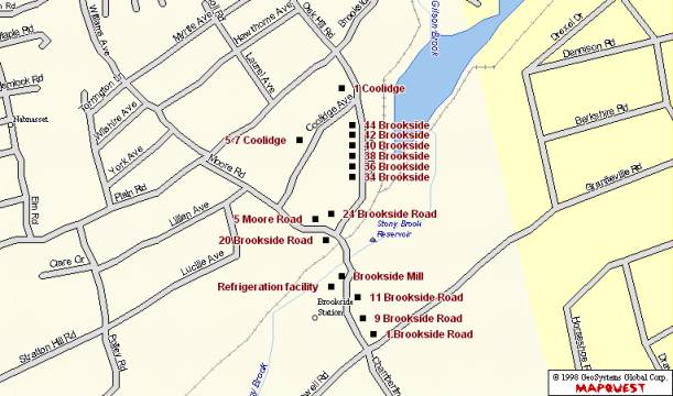
Sketch Map North
Toward Top
Fairview Cemetery
Description
Introduction
Fairview Cemetery came into use in the early 18th century. The precise date of the first burial has not been determined but an early stone marking the grave of Abram Wright is reputed to bear the date 1702. During the Colonial Period, the appearance was that of a small cleared parcel of land occupied by slate markers with arched tops. Fairview retained this form until the late 19th century when, in imitation of Rural or Garden style cemeteries in many other Massachusetts communities, the local Commissioners of Public Cemeteries caused stone walls and gateways, plot plans and curving avenues to be created. This activity affirmed that Fairview would become the town’s principal place of burial.
Given its status as the town’s oldest, largest and most fashionable resting place, it attracted the leading industrialists, politicians, ministers as well as mill hands and farmers. The variety of personal backgrounds is matched by the variety of grave marker sizes and types. Large granite obelisks are found adjacent to diminutive marble tablets. Arched slate markers from knee height to six feet are present. A variety of other types is scattered throughout the cemetery.
Colonial and Federal Period slate markers, numbering in the hundreds, are well preserved and demonstrate typical artistic conventions and motifs such as death’s heads, portal designs and urns under willow trees. Markers from these periods are divided geographically from later examples by the difference in circulation patterns. Slate markers are placed amid a grassy section that continues to bear evidence of short glacial mounds of earth such as existed prior to centuries of plowing and grading. No avenues exist between stones in this area. These occupy a central rectangular area, known as the Old Division, that abuts Main Street.
Victorian Period gravestones are mostly carved from granite, a locally quarried material. Standard forms such as tablets and chests exist along with unusual examples such as a millstone and a sphere. A single monumental bronze example has been identified. Plots from this period are frequently delineated with curbs and corner posts. Nearly a dozen gravestone carvers, some with several markers to their credit, have been identified.
In addition to occasionally ornate grave markers, some sections of Fairview have winding paths and avenues to provide access to plots. Ground in this area has been graded to reflect gradual changes in elevation. Mounds have been removed to accommodate circulation paths and organization of plots. These changes came in response to trends in cemetery design promoting the picturesque, part of which consisted of renaming the former East Burying Ground to Fairview Cemetery in 1904. The curvilinear portion, known as the East Division was added in 1876. Additional land was again added in 1924 (New Division) and in 1936 (Tadmuck Division). The cemetery continues in use today, but has run out of plots to sell.
Landscape
The 18th century appearance of the East Burying Ground was that of a grassy half-acre parcel of short rolling mounds occupied by arched slate gravestones. Located immediately south of Main Street and one mile east of the town center and meetinghouse, the burial ground was mowed and its volunteer growth of bushes trimmed as if it were a farm field. Nineteenth century structures include tombs in the center of the burial ground on two sides of a low earthen mound and two tombs built into the stone wall that lines Main Street. Ornamental trees planted on the grounds include maples, oaks, hemlocks and a variety of evergreen species. Nineteenth century efforts to improve the appearance of the burial ground by grading and constructing avenues among the stones encompassed land on three sides of the Colonial Period burials. A short embankment distinguishes between the rolling mounds of un-tilled earth around earlier burials and the more gradual changes in elevation that were the result of attempts to create a Garden style cemetery.
Walls
Stone walls separate the cemetery from Main Street and from Tadmuck Road. The most refined in materials and design is the segment from the corner of the two roads heading east to the main gateway. This is coursed granite ashlar construction three to four feet in height with flat capstone. From the main entrance to the eastern end of the Main Street side is a similar granite ashlar wall of older, uncoursed construction and a similar capstone. The entire wall is approximately 1000’ long. The Tadmuck Road side of Fairview Cemetery is lined with approximately 500’ of two to four foot high cobblestone wall with concrete cap. The rear or south boundary of the cemetery is lined with dry-laid fieldstone that may have been built as part of an adjacent farm field boundary.
Gateways
The cemetery acquired some refinements in appearance with construction of stone gateways on both the Main Street and Tadmuck Road sides. Most prominent is the main gateway halfway along the Main Street side. Here, two coursed ashlar granite walls curve into the cemetery and toward each other in 90-degree arcs ending in square nine-foot high pillars with square capstones. Secondary pillars mark the departure of the curved sections from the main wall. The corner access at Main Street and Tadmuck Road has a similar arrangement of pillars without the curving wall segments. Both have stones in one pillar bearing the name “Fairview.” The Tadmuck Road entrance is flanked by two round pillars built of cobblestone to a height of seven feet. The eastern end of the Main Street side has an unornamented secondary access through the ashlar granite wall for vehicles that is unornamented. A flight of three narrow steps is built into the Main Street wall near the mid-way point.
Paths
Circulation among plots is guided in the eastern and western sections of the cemetery by a system of asphalt paths or avenues, ten feet in width. The more picturesque curvilinear avenues emanate from the secondary Main Street entrance. Diverging to the east and west, paths follow a winding course toward the south and meet near the rear of the parcel, encompassing the 19th century addition to the East Burying Ground. A central winding route nearly bisects these paths around the perimeter. The 1876 plan of this section of the cemetery grounds reflects among these avenues several narrower paths that may have once existed as dirt surfaced footpaths but are now planted in grass and of uncertain direction. The principal gateway on Main Street gives onto two straight parallel avenues heading directly to the rear of the cemetery with a transverse avenue gradually curving to the east and connecting to the more picturesque section of the circulation network. The central 18th century section of the cemetery has no paths between markers. Newer sections of the cemetery in the west and south also have asphalt avenues that are mostly straight except for a loop in the northwest corner, site of current burials. While not consistently apparent, a small number of curbs and low piers mark some edges and corners. The most ornate is close to the secondary entrance from Main Street and has a granite ball and curbstones marking the corner of two converging paths.
Plot Delineation
Plots in Fairview are delineated in some cases with granite curbstones. These are alternatively flush with the ground or elevated up to a foot above grade. In some cases, such as the Abbot - Cameron plot, the front is lined with stones near grade level while granite slabs at the rear of the plot act as a three-foot high retaining wall, thereby leveling the plot on its sloping site. A single iron fence remains in existence at the Thomas and Edmund Symmes plot. Ornate pales with pointed ends are connected by filigree and low granite posts to enclose an area of approximately eight by ten feet. It is likely that there were at one time many more such plot defining fences but that they have been removed to ease the chore of mowing.
Tombs
Three tombs exist in Fairview, two of which are incorporated into the Main Street wall. The Town Tomb, marked as such on the 1938 cemetery plan but not so on the actual structure, has a low pedimented slab of granite rising slightly above the level of the wall. Two stout vertical slabs of granite flank the central iron door. Adjacent to the Town Tomb on the east is the Solomon Richardson family tomb, marked with a slate tablet that names nine family members interred from 1817 to 1902 and is set into the granite entry. The only tomb inside the boundaries of the cemetery contains five families: Heywood, Keyes, Proctor, Fletcher and Abbot. The low mound of earth at the south end of the 18th century section has tablets for two families on the east side and three on the north. Dates of these interments range from 1816 to 1926. Construction of doors is primarily granite with some inset slate tablets carved with names and dates. Modern granite tablets with names and dates have been added posthumously during the 20th century to the Abbot marker.
Buildings
Two buildings exist in the southwest corner near Tadmuck Road. The former Hearse House, also called a tool house on the 1938 plan and now used as the superintendent’s office, is a one-story, side-gabled frame building sheathed in wood clapboards. The plan is two by two bays. Architectural ornament includes gable returns, corner boards and molded trim at the eaves. Modern windows have been installed. The outline of a vehicle door exists on the west elevation, which backs up to the cobblestone wall along Tadmuck Road. The proximity of the door to the wall now prevents vehicles from entering and suggests either that the building was moved or the wall was built after the need for the door was obviated. A shed ell expands the rear of the plan. A modern gabled shed or storage building is oriented perpendicular and immediately adjacent to the former hearse house. Three overhead doors on the east elevation provide access to the interior of the shed.
An open, wood-framed octagonal building with octahedral roof, approximately ten feet across and 12 feet high, is described in town reports at the time of construction as the “Summer House.” Turned posts with jigsawn brackets support the roof. A jigsawn baluster and benches on seven sides rim the floor. A pointed brass finial occupies the peak of the roof.
Markers
Fairview Cemetery reflects trends in gravestone development in its variety of slate, sandstone and granite markers. Slate is the oldest surviving material used for marking burials and is carved in arched, shouldered-arched and flat-topped tablets. Ranging in height from one foot to over five feet, this type of marker can demonstrate a relatively crude, hand cut appearance, a well-designed and possibly machine cut sharpness and several levels of workmanship in between.
Quality of workmanship of the slate marker is sometimes obscured by the fact that the stone has deteriorated or been broken. Inscriptions also vary in quality and detail. The simplest have fine, narrow letters with little relief or depth. Some of this type are well organized and clearly laid out. Others are jumbled in the way words are divided among lines. Later slate stones from the 19th century are more likely to demonstrate clear, deep, stylized letters with a pronounced serif and well thought out organization relative to the shape of the stone.
Markers appear in a variety of shapes. Those from the earliest period are most commonly cut in a rectangular form with an arched top, representative of the figurative portal between life and death. The shape is also considered an abstraction of the human head and shoulders. This form of marking the passage from life is a Puritan concept brought from Boston and elsewhere during the region’s period of first settlement. Eighteenth century stones are typically carved with one of a variety of motifs. The earliest marker in Fairview, thought to be that of Abram Wright from 1702, is unidentified. Other early stones have faces inscribed in portals, such as the 1783 slate marker of Ephraim Hildreth. Representative of the spirit of the deceased glancing back into the world of the living while simultaneously offering the living a preview of the afterlife, the portal is rich in Puritan symbolism and attitudes toward the transcendent nature of death. In addition to the portal are rows of diamond trim at the edges of the marker.
The symbol of winged death, in the form of either a skull or abstracted human head flanked by a pair of feathered wings spread wide, occurs frequently on stones carved in the late 18th century. This is another representation of the belief that the human spirit was released at the time of death for the flight heavenward. An example of this design motif is found on the double arched stone of brothers Ezekiel and Timothy Hildreth, who died in 1747 before they turned three years old, possibly because of small pox. They are remembered by a double-arched stone with floral trim and a pair of death’s heads flanked by wings and decorative circles. Circles figure prominently in the design of the slate marker for William Chandler who died in 1757 at the age of 67. Here, the winged skull is sited below the legend “momento mori”, a reminder to the living observers of their impending deaths. At the peak of the arched stone and above all other design features, are three concentric circles that symbolize eternal life and resurrection. Deacon Paul Fletcher, who died in 1735 at the age of 57, is buried beneath a stone with a death’s head, circles and flowers but without wings.
Based on classical influences exerted by the spreading glow of the Enlightenment, new images for gravestone ornamentation rapidly made the older themes seem outdated. Urn and willow designs appear frequently on gravestones from the Federal through the Victorian Period. Both slate and sandstone markers exhibit this late 18th and early 19th century motif that is an icon of sorrow and grief. A sculptural granite example also exists. Change from the puritan death’s head to the classically inspired urn and willow marked a change in the way death was viewed by New England society. Previously, the event was considered a common reality whose dim portent reflected the stern view of life as a struggle for survival. The Post-Puritan view of death adopted a sentimental quality that spoke more of the emotional state of those left behind than of the journey of the deceased, causing the replacement of darkly spiritual carvings with abstract sorrowful imagery. The use of columns in gravestone design, frequently of the Doric order, is evidence of the pervasive influence of imagery popularized by publications and designs featuring drawings of classical architecture. Major Jonathan Minot’s 1806 slate marker has an urn and willow design in its arched top with Doric columns flanking a central panel for the inscription.
A marker type with one example in Fairview is the tablestone used to mark the grave of the Reverend Willard Hall. Here, three vertical granite slabs support a horizontal slate slab inscribed with Reverend Hall’s dates and commemoration of his service to the First Church of Christ in Westford. The grave is also marked by a cast iron Maltese cross placed by the Sons of the American Revolution. The British flag identifies the minister as a Tory.
Additional marker types in the form of obelisks, chests, and tablets with biblical and classical symbolism appeared during the Victorian Period. Obelisks are carved mainly from granite although several early sandstone examples are present. This type of marker was in frequent use from the mid 19th century forward and ranges from six to 15 feet tall. The most prominent example, marking the burial site of the family of John William Pitt Abbot, is carved of pink granite. Its polished facets are inscribed near the base with dates for Mr. Abbot, his wife and three children. This is the largest monument in Fairview. Numerous other obelisks are from the late 1800s and have capstones and smooth, polished granite faces.
Chest markers appear throughout the cemetery with dates from the mid 1800s to the present. These are larger than tablets and are most frequently cut from granite. The William E. Frost (1842-1904) chest marker is an unornamented rectangle with polished front and rear faces. Edges of the marker have a rough quarry-faced finish. The Albert P. Richardson (1843-1903) chest marker, however, has all faces polished smooth and is trimmed with a floral motif and ovolo molding at the top.
Tablets with biblical symbolism appear, usually in marble. A poignant example is that of Agnes Cameron who died eight days after her birth in 1865. She is remembered with a small white marker topped with a lamb, symbol of youth and innocence.
Some non-traditional marker types appear in Fairview. Along the northern boundary of the cemetery is the marker for the mill owner George Heywood (1829-1914) and his family. The inscription appears in the polished circular face of a granite millstone. The rear of the marker has grooves as in an actual grindstone and may have been taken from the Heywood mill located at the crossing of Depot Street over the former Stony Brook Railroad (now CSX). The Griffin family marker is unusually large and has the cemetery’s only spherical ornament. Made of polished pink granite and resting on a stout pier and gray granite base, the sphere measures approximately three feet in diameter. The marker commemorates the lives of Joseph B. Griffin (1816-1896), his wives Deborah (1807-1848) and Eliza (1835-1912) and three other family members.
A single example of a zinc grave marker exists in Fairview and commemorates the Charles J. Searles (1836-1901) family. This unusual marker is the product of the Monumental Bronze Company of Bridgeport, Connecticut, which operated from the 1870s until after WW I. The three-foot high imitation stone is made to resemble quarry-faced granite in the form of a shortened obelisk. The top is ornamented by a rounded finial above a flared molding and hollow shaft. Below the shaft, the base flares in four-peaked fascia, the southerly of which bears the family names. This is the only known zinc monument in Fairview Cemetery but they are commonly found in cemeteries across the nation.
Military markers in Fairview are scattered throughout the cemetery. Charles Brooks is buried beneath a typical low arched marble tablet inscribed with the military unit with which he fought in the Spanish American War. Similar markers appear for veterans of the Civil and World Wars. Soldiers involved in actions prior to the Civil War are remembered by their ranks inscribed with their names, usually on slate markers. Many military markers are redundant, located adjacent to family stones that repeat dates for veterans.
Carvers
The earliest known gravestone carver’s name to appear is that of I. Hartwell who carved a marble marker for Horace Parker, MD in 1829. Later stones bear carvers’ names and locations such as F. A. Brown of Derry, New Hampshire and A. Stone of Groton. B. Day, Charles Wheeler, T. Warren and D. Nichols, Gumb Bros. all had workshops in Lowell. Such evidence suggests this industrial center to the east was the primary community for buying items not available locally such as gravestones and other manufactured goods. The J. W. P. Abbot obelisk bears the inscription A. MacDonald Field & Co. Aberdeen.
Existing Conditions
Fairview has evolved into a modified rectangle and is currently known by four Divisions. The Old Division West occupies the center of the plan and abuts Main Street at the north. The East Division is recognizable by its curvilinear path network drawn in the 1870s by Edward Symmes. The New Division comprises a narrow rectangle at the south and was added in 1924. The Tadmuck Division, added in 1936 and landscaped between 1938 and 1953, occupies the west end of the overall plan. While records do not indicate as much, it is possible that, since few remain, footstones were removed as part of past efforts to tidy the grounds. Repairs have been carried out in the cemetery on a regular basis since the 19th century, resulting in visible repairs to some slate stones. Since the material is particularly susceptible to cracking and toppling, several different methods have been used to stabilize markers. There are some which have been re-set in concrete footings poured at ground level. Others have been re-attached at severed points with metal braces and bolts or cemented or glued across fractures. Most stones remain in good to excellent condition, although some slate markers are difficult to read due to erosion. The Cameron family marker appears originally to have had a finial which is now missing. While very little other vandalism has taken place, damage has been sustained in many cases due to scraping by lawn-mowing equipment. However, the large number of remaining 18th and 19th century markers make it possible to get a clear sense of historical burial and gravestone carving techniques in Westford.
Statement of Significance
Introduction, 1700-1830
Originally called the East Burying Ground (also called Snow’s after the former groundskeeper and neighbor Levi Snow), Westford’s first place of burial came into use before the founding of the town in 1729. While still considered Chelmsford’s West Precinct, Abram Wright was interred here in 1702. This is the earliest recorded burial although there were likely previous occupants. The record for Mr. Wright appears in the 1883 town history written by Edwin Hodgman who claims to have examined all existing markers. This occurred at a time when far more of the inscriptions were legible than is the case today due to erosion and other types of damage. Mr. Hodgman’s usually exacting efforts to reveal town or precinct records for establishment of the burial ground were fruitless. The 1702 stone is unidentified.
Bounds of the burial ground were found in 1753 by a committee chosen for the purpose at town meeting. It appears that even at that time, much of the origins were unclear. After agreeing upon property lines in relation to surrounding farmland, the committee lost little time in erecting a gate and horse mounting block, neither of which are evident today. Adjacent landowners Thomas Cummings and Josiah Brooks donated to the town in 1768 parcels for expanding the grounds by 18 rods to the south and an additional 30 rods in an undetermined direction.
Occupants of the East Burying Ground from the period include the town’s first mill owner, William Chandler (d. 1756, 67 years of age) who operated a fulling mill on Stony Brook near the current Brookside Road, Deacon Paul Fletcher who was chosen as such on January 5, 1733 and who died just two years later at the age of 57, Joseph Underwood (1681-1761) who was responsible for the sale to the town in 1748 of the parcel of land that became the Common, Deacon John Abbot (1713-1791) who was a selectman, school teacher, town clerk and progenitor of a leading family of industrialists, Reverend Willard Hall (d. 1779) who was the Tory minister of the First Parish Church from 1729-1775.
Revolutionary War veterans who fought in the Battle of Concord in April 1775 and were recognized by the Sons of the American Revolution with iron cross markers in 1902 include First Lieutenant Zaccheus Wright (later Captain at the Battle of White Plains, NY), Sergeant William Hildreth, Corporal Hosea Hildreth and Sergeant Major Jonathan Parker who also fought at Bunker Hill.
Less well-known residents tell of other aspects of the town’s history. Ezekiel and Timothy Hildreth share a double arched slate marker. Children of Abigail and Joseph Hildreth aged under three years, they both died in January 1747. This and other examples in Fairview of the loss of multiple children remind modern visitors of the hardships of Colonial life. Approximately 300 Colonial Period slate markers occupy the central part of the cemetery. The North and West Burying Grounds (now called Hillside and Westlawn) were in use by this time. These are smaller than Fairview and occupy sites farther from Westford Center.
1830-1897
The transformation from burial ground to the local version of a Rural style cemetery began nearly ten years after the founding in 1831 of Mount Auburn Cemetery in Cambridge. Nationally influential for its landscape designed by horticulturists and landscape architects and its governing body’s intention to beautify the final resting place, Mount Auburn served as a model to cemetery commissions across the country. Over a period of nearly 40 years, Westford’s cemetery commissioners would gradually create a simple version of a Rural cemetery by building walls, grading circulation paths and planting trees and shrubs.
The 1840 town report indicates the stone cutter and Westford resident Nathan S. Hamblin was paid $90 for building a wall and setting stone posts. In the same year, B. F. Keyes was paid for building and painting a fence. No evidence remains of a fence from the period but some portion of the stone wall lining Main Street from the main gateway to the northeastern corner is likely the work of Mr. Hamblin. Levi Snow was paid in 1858 for laying 24 ½ rods of wall (392 feet) which may have been the un-coursed granite section at the east end of the Main Street side. Asia Nutting was paid $101.50 for unspecified stone work in 1868. In 1880 the selectmen reported in favor of building a faced stone wall and began advertising for construction proposals, finally selecting that of George Yapp who lived three miles away on Concord Road near Hildreth Street. By 1883, Mr. Yapp had built the western 580’ feet of wall along Main Street using material quarried in Graniteville, thus completing the 1000’ of granite wall now extant. No mention is made at this time of the granite gateways but they were likely built at this time.
A new hearse house was built in 1870 by George Drew. This is likely the existing Superintendent’s Office at the southwest corner of the cemetery. Given the expansion of the grounds, the former hearse house has probably been moved so as to remain in a remote corner as the cemetery expanded. Town reports note that Mr. Hamblin was paid in 1871 for constructing the Town Tomb built into the Main Street wall. The first mention of the tomb appears in cemetery records on February 12, 1871. Prior to its construction, people who died during months when digging was impossible were temporarily interred in private tombs of other townspeople.
Cemetery commissioners acquired appropriations for another method of improving the appearance which involved re-setting older gravestones, presumably to put upright those that were leaning or had fallen. Colonial Period stones are now arranged in neat rows, oriented north to south, with most family members close together. The current absence of footstones may have come about as a result of this effort to tidy the grounds. Commissioners not only improved the burial ground’s appearance in these years but bought 38 rods of land from Joseph Henry Read in 1874 in order to expand the space available for burials.
The purchase of additional space and the community will to improve the burial ground led to a survey of the land in 1876. Locally prominent civil engineer Edward Symmes, a Fairview occupant who lived from 1806-1888, was retained to create a plan in a style fitting a Garden cemetery. Mr. Symmes also created the 1855 map of Westford. The result of the 1876 survey is the existing network of curvilinear paths and individual plots in the East Division. Water features were an integral part of Garden style cemetery planning for their ability to encourage reflection and to impart a sense of calm. Mr. Symmes appears to have intended a fountain to be built in a circular plot near the center of the cemetery, which, by the time of the 1938 cemetery plan, had been precluded by the plot’s use for a burial.
An important aspect of the process of transforming the East Burying Ground into the local version of a Garden style cemetery was that of deciding upon a new name. There were “many ladies” who, at the invitation of the cemetery commissioners, signed a petition in 1896 suggesting the name Fairview. The petition was immediately granted.
In addition to the creation of picturesque paths and avenues, cemetery commissioners created in 1894 a procedure for residents to reserve lots and either to pay the town one or two dollars annually for maintaining them or to establish a perpetual care fund in the amount of $50 to $100, the interest of which would pay for labor to trim shrubs and mow grass. Interest in establishing such funds was intense for the subsequent five years as can be seen in the legend “Perpetual Care” carved on many markers from the period.
A campaign of tree planting was begun in 1895 which continued for many years. Maples, red cedar, spruce and hardy shrubs were set out. Ornamental plantings continue to be an integral part of the designed landscape although few examples have survived from the late 19th century. The final addition to the cemetery during the period of refinement was the octagonal Summer House. The open-walled building was designed and built in 1896 by local carpenter William Edwards who was responsible for many other Westford buildings such as the 1870 Town Hall and the 1895 J. V. Fletcher Library.
Westford Residents interred at Fairview during the 19th century include the full range of economic, educational and social backgrounds. Indeed, nearly all burials taking place in the town by the end of the period occurred in Fairview due largely to its improved landscape. John William Pitt Abbot, Esq. (1806-1872) is buried with his family on a plot distinguished by the tallest marker in the cemetery. Mr. Abbot’s prominence in the community stemmed from his practice of law, title of president of the Stony Brook Railroad, involvement in the family industry of woolen manufacture in Graniteville and Forge Village, service to the town as selectman, town clerk and Westford Academy Trustee, service to the church as clerk for 40 years, and to the commonwealth as representative and senator. George R. Moore (1817-1892) is another mill owner buried in Fairview. He owned a number of companies in Chelmsford and the woolen yarn mill in the village of Brookside in Westford. Another resident of Fairview is Luther Wilkins, a farmer who lived with his wife and four children on the edge of the village of Westford Center. Mr. Wilkins’ son Luther E. Wilkins served in the Union Army in the Civil War. Other residents from the period include the town physician Dr. Benjamin Osgood who died in 1863 and Ira Leland (b. 1798), a butcher and farmer from Westford Center.
The cemetery had only a few groundskeepers during this period. From 1835 until his death in 1869 it was the farmer Levi Snow, who lived across the street and for whom the burial ground was occasionally called prior to its being renamed Fairview. His son George Snow performed the duty for two years until Samuel M. Hutchins took responsibility in 1871 and kept it until 1893. Mr. Hutchins occupied the house across Main Street from the cemetery after Levi Snow. Albert P. Richardson was the town’s Cemetery Superintendent and maintained Fairview into the 20th century until the time of his death in 1902.
1897-1950
Two parcels of adjacent land were added during the early 20th century to the cemetery’s southern boundary. The first was in 1924 and is now called the New Division. In this narrow rectangle, circulation paths adhere more closely to a grid pattern. Another parcel was added in 1936 to the western boundary abutting Tadmuck Road. A plan of the parcel from that year shows it outlined with dry-laid fieldstone walls such as a farmer might build to clear the land. Town reports from the years of the Great Depression contain sections that describe work done by members of the Works Progress Administration (W.P.A.). The W.P.A. report for 1938 discusses stone wall construction that was planned to enclose two sides of the cemetery, suggesting the existing cobblestone wall was W.P.A. work performed at that time.
Family members and friends of those interred established numerous trust funds to pay for maintaining plots. Markers are carved with the legend “Perpetual Care” as a way to notify groundskeepers of which plots get constant attention. The words may also have been a notice to passersby that the occupant enjoyed a certain level of status among cemetery residents. Costs for reserving burial plots during this period was two to five dollars. Perpetual care required the establishment of a trust fund, usually around $100. It appears from names printed on gravestones that, while a handful of people with apparently Irish surnames were buried in the 19th century, there were very few non-English occupants of Fairview until after the addition of the New Division in 1924.
Markers were placed in 1902 at the graves of Revolutionary War veterans by the patriotic and historical organization Sons of the American Revolution. Westford veterans who had been at the Battle of Concord received the S.A.R. emblem, an iron Maltese cross with an image of Daniel Chester French’s sculpture entitled The Minute Man. A Soldiers’ Lot, established in 1906, was reserved for veterans of the Civil War. In 1909, the town received from the United States Government six stones for marking graves of Civil War veterans. These are marble with low arched tops.
A small section exists on the 1938 plan of the cemetery labeled “Strangers’ Row”. The 1876 version of the plot plan of Fairview makes no mention of this parcel and was probably reserved for the indigent or for those simply with no family nearby. The plot is approximately 15’ by 30’ and has no markers however a total of 14 people were buried in the plot from 1907-1939. Sadly three of these are listed in cemetery records as “Unknown”.
Residents of Westford from the period who had an impact on town history and who occupy Fairview Cemetery include an array of industrialists, town officials, farmers and politicians. As in all other periods, members of the Abbot family of woolen mill owners were interred here. Several generations of this family were responsible for building the mills and much of the neighborhood of Graniteville and Forge Village with their side streets of worker housing. Adjacent to the J. W. P. Abbot family marker is that of Allan Cameron (1822-1900), a Scottish immigrant who worked first as a machinist and later operated a woolen yarn manufacturing concern. Mr. Cameron is the namesake of a former public grade school in Forge Village and was a family friend and business associate of the Abbots. George Heywood (1829-1914) was also an industrialist but on a smaller scale. He operated a grist mill at the Depot Street crossing of Stony Brook in the second half of the 19th century. Mr. Cameron and Mr. Heywood were commissioners of public burial grounds from 1892 to 1897. Frank Furbush (1861-1940) owned a gas station and auto repair shop in the village of Graniteville in 1921. In addition to his work on cars, Mr. Furbush acted as a manager at the woolen machinery manufacturing firm C. G. Sargent and Sons in Graniteville.
William E. Frost (1842-1904) was a very active public servant and is interred in Fairview. Mr. Frost worked as preceptor of Westford Academy from 1872 to 1904, and was namesake of the William E. Frost School on Main Street. He was educated at Bowdoin College and is said to have brought modern educational practices to Westford Academy. He was involved in the management of the J. V. Fletcher Library, and was a commissioner of public burial grounds from 1892 to 1897. Albert P. Richardson (d. 1902) was cemetery commissioner and caretaker of Fairview Cemetery. Farmers occupy many plots in Fairview. Oren Coolidge (1800-1872) who lived at 17 Forge Village Road for many years is interred here. Wayland Balch (1839-1937), the latest living Civil War Veteran from Westford, occupied farm houses at 24 Boston Road and 246 Concord Road during the late 19th century. He found his final resting place in Fairview.
Politicians of some note are interred here. Herbert Ellery Fletcher (1862-1956) occupies, with his wife Christina (1846-1912) and her family a granite above-ground tomb probably built with material taken from Mr. Fletcher’s quarry. In addition to operating the town’s largest granite quarry and a successful construction concern, Mr. Fletcher served in the state senate from 1901-1903, performed duties as delegate to the 1916 Republican National convention, and served in the Massachusetts General Court. He was a graduate of Westford Academy. Joseph Henry Read, (d. 1901) also a politician, served in local and state government and was a native of the town. He graduated from Westford Academy in 1855 and went on to become selectman, school committee member, county commissioner and a representative to the Massachusetts State Legislature.
Nettie Stevens (1861-1912) is distinguished among those at Fairview by virtue of her outstanding accomplishments in the field of biology. After studying at Westfield Normal School and completing the course of study in half the usual time, Ms. Stevens took a job teaching at Westford Academy from 1885 - 1892. She then attended Stanford University, graduating with a M.A. in 1900, and Bryn Mawr, teaching and earning a Ph.D. in 1903. The daughter of a local carpenter and graduate of Westford Academy, she died prematurely at Johns Hopkins University Hospital due to a fall in 1912.
Lieut. William Metcalf (1819-1900), who is interred in Fairview, was a Civil War Veteran and native of England. Mr. Metcalf worked as a mechanic, served in the 16th Massachusetts Infantry and lived near the corner of Boston and Littleton Roads. He was remembered after his death in 1900 by his son who commissioned the Metcalf Civil War Memorial, a bronze statue in Westford Center dedicated in 1910 to all Civil War veterans from the town.
Non-Anglo names appear in increasing numbers during this period. While many Irish, English, Russian and Polish immigrants worked in factories in the town starting in the 1850s, Fairview seems to have been favored by members of long-established Westford families. Those with surnames not of English extraction, such as O’Brien and Walkovich begin to appear in the parcel of land added to the cemetery in 1924.
Conclusion
The history and development of the East Burying Ground, renamed Fairview Cemetery in 1896, follow a path similar to many other cemeteries in New England. As in other communities, Fairview began during the 18th century as a cleared but otherwise unimproved parcel dedicated to burial of town residents. Major changes occurred as a result of 19th century trends in landscape design. These trends combined with the spirit of community involvement as seen in the numerous fraternal and social organizations of the time as well as the desire among rural residents to imitate more stylish urban examples of houses, dress, cemeteries and other aspects of life, combined to guide the will of Westford residents to create Fairview Cemetery.
Geographical Data
Verbal Boundary Description
Fairview Cemetery comprises all of the land within the boundaries of the cemetery. It is bounded by Main Street on the north and by properties on Fairview Drive on the south and east. Tadmuck Road forms the western boundary. The cemetery encompasses 10.45 acres, described by the assessor’s office as parcel 170 on map 27.
Boundary Justification
Boundaries of the cemetery were determined by the Westford Historical Commission and by the consultant. Boundaries include all gravestones, burial-related buildings, structures, circulation paths and ornamental plantings. Stone walls encircle the cemetery and mark all boundaries.
SKETCH MAP NORTH
TOWARD TOP
Westlawn Cemetery
Description
Introduction
While the name Westlawn Cemetery implies existence of characteristics of the Rural Cemetery movement inspired by construction of Mount Auburn Cemetery in Cambridge, the landscape layout, appearance and gravestone art of the burial ground adhere more closely to design characteristics from the Colonial Period. Acquired from local farmers by the town as a burial ground in 1761, it was originally called the West Burying Ground. Many of those interred here are significant in the history of the Town of Westford. War veterans, mill owners and operatives, farmers and business people occupy the approximately 400 visible burials. Members of the Robinson, Prescott, Day, Fletcher and other families influenced the town’s history and appearance and continue to do so by virtue of their artfully carved gravestones.
Markers are made primarily from slate although many granite, sandstone and marble examples are present. Colonial and Federal Period grave markers appear in the form of arched, shouldered-arched and flat-topped tablets, the largest of which belongs to Colonel John Robinson, leader of Westford minutemen at the Battle of Concord on April 19, 1775. While Colonel Robinson’s slate marker has a refined urn and willow motif in its arched top, other slate markers have more primitive designs of death’s heads, faces inside portals and winged skulls.
Monuments from the Victorian Period take the form of obelisks and chests as well as tablets. Slate continued to be used after the Federal Period although marble and granite became more common. The Carver family chest marker was carved in the late 19th century from brown granite and placed atop an earthen mound near the western corner of the cemetery. This is one of Westlawn’s larger and more ornate markers and represents a departure from the simpler tablet form. It was probably during this time that residents placed granite curbs and low corner stones around the perimeters of some plots.
Grave markers are arranged in rows oriented east to west with inscriptions on older stones typically facing south. Three tombs are built in a row parallel to Concord Road, one of which has a retaining wall built of brick bearing inset slate tablets inscribed with names and dates of those interred. Other tombs are earthen mounds four feet in height with granite entry surrounds and iron doors.
Landscape
Land comprising the West Burying Ground belonged in the Colonial Period to Samuel Parker, a local farmer. The appearance at the time was likely that of a field of grass with a few small slate gravestones. The triangular, flat, grass-covered parcel is located in the pointed vertex of the junction of Concord and Country Roads.
Entrance to the cemetery is thorough openings in the fence along the Concord Road (south) side and at the eastern point of the triangle where Concord and Country Roads meet. The long southerly edge is broken at about the mid-point by a pair of low granite posts with mounts for iron hinges. Gates which hung from the posts are no longer extant. Additional entry is through a gap in the fence at the eastern end. Boundaries of the cemetery are lined on the south and half of the west edge with chain-link fence four feet in height. The northern boundary and half the west have a two-foot high fieldstone wall. A modern flagpole occupies a site just inside the east entry. Rows of pine trees form a line just inside the south and north walls.
Plot definition occurs in 17 instances with simple granite curbs located flush with the ground or as much as 18 inches in height. The Blood family plot has curbing laid at ground level. Many have corner piers that rise slightly above the level of the curbstones. The multigenerational Day family plot, with its varied slate, sandstone and granite markers, is enclosed with this type of border. The Wright family plot near the west end has four-foot high granite obelisks, unique in the cemetery, to mark its edges. Nearby, the Hildreth-Davis family burials have a granite step to access the slightly elevated plot. Curbs enclose square and rectangular parcels of from eight to twenty feet per side and are more common at the west end.
Markers
Westlawn Cemetery reflects trends in gravestone development in its variety of slate, sandstone and granite markers. Slate is the oldest surviving material used for marking burials and is carved in arched, shouldered-arched and flat-topped tablets. Ranging in height from one foot to over five feet, this type of marker can demonstrate a relatively crude, hand cut appearance, a well-designed and possibly machine cut sharpness and several levels of workmanship in between. Quality of workmanship of the slate marker is sometimes obscured by the fact that the stone has deteriorated or been broken. Inscriptions also vary in quality and detail. The simplest have fine, narrow letters with little relief or depth. Some of this type are well organized and clearly laid out. Others are jumbled in the way words are divided among lines. Later slate stones from the 19th century are more likely to demonstrate clear, deep, stylized letters with a pronounced serif and well thought out organization relative to the shape of the stone.
Markers appear in a variety of shapes. Those from the earliest period are most commonly cut in a rectangular form with an arched top, representative of the figurative portal between life and death. The shape is also considered an abstraction of the human head and shoulders. This form of marking the passage from life is a Puritan concept brought from Boston and elsewhere during the region’s period of first settlement. Eighteenth century stones are typically carved with one of a variety of motifs. The earliest marker in Westlawn, that of Bridget Read who died in 1760 at the age of 30, exhibits a death’s head in a carved arched portal. Representative of the spirit of the deceased glancing back into the world of the living while simultaneously offering the living a preview of the afterlife, the portal is rich in Puritan symbolism and attitudes toward the transcendent nature of death. In addition to the portal and death’s head are abstracted floral patterns at the edges of the marker and the legend “momento mori”, an encouragement to the living to remember that death is imminent. Mrs. Rebecah Prescott, wife of Lieutenant Jonas Prescott, who died in 1795 at the age of 65 is remembered by a stone with floral trim and a death’s head inscribed inside an oval.
The symbol of winged death, in the form of either a skull or abstracted human head flanked by a pair of feathered wings spread wide, occurs frequently on stones carved in the 18th century. This is another representation of the belief that the human spirit was released at the time of death for the flight heavenward. An example of this design motif is found on the stone of Elizabeth Marshall who died at the age of 36 in 1789. Her marker has the legend “momento mori” inscribed in a banner below the symbol of death.
Based on classical influences exerted by the spreading glow of the Enlightenment, new images for gravestone ornamentation rapidly made the older themes seem outdated. Urn and willow designs appear frequently on gravestones from the Federal through the Victorian Period. Both slate and marble markers exhibit this late 18th and early 19th century motif that is an icon of sorrow and grief. Change from the Puritan death’s head to the classically inspired urn and willow marked a change in the way death was viewed by New England society. Previously, the event was considered a common reality whose dim portent reflected the stern view of life as a struggle for survival. The Post-Puritan view of death adopted a sentimental quality that spoke more of the emotional state of those left behind than of the journey of the deceased, causing the replacement of darkly spiritual carvings with abstract sorrowful imagery. The use of columns in gravestone design, frequently of the Doric order, is evidence of the pervasive influence of classical imagery popularized by the Enlightenment. Lieutenant Jonas Prescott’s 1813 slate marker has an urn and willow design with Doric columns and floral patterns at the borders. The Jonas Hildreth slate marker from 1808 is edged with Doric columns topped with pineapples flanking a central panel with names and dates. The arched top bears the image of an abundant willow tree weeping over a classical urn.
Additional marker types in the form of obelisks, chests, intricately carved Gothic designs and tablets with biblical and classical symbolism appeared during the Victorian Period. Obelisks are carved mainly from gray granite with one example resting on a pink granite base. This type of marker is typically around six feet tall and was in frequent use from the mid 19th century forward. The earliest example, marking the 1829 burial site of John Blodgett, was carved of rough cut granite without ornament. Others are from the late 1800s and have capstones and smooth, polished granite faces. Lawrence, Leighton and Herrick family markers are of this type.
Chest markers in Westlawn are granite, some with a finely polished finish. The Carver Family monument from the 1890s is the largest and most ornate example with its half-round crested top, colonettes with carved floral ornament at the corners and bold lettering at the base. The Day family plot has a granite chest marker for Isaac (1826-1898) and Lucy Day (1832-1927) with a scroll top, comparatively rough finish and little other ornament.
Gothic design motifs in the form of vegetation and architectural detail are applied to marble markers from the mid 19th century. Carrie Rathbone, (d. 1857, 26 years of age) is buried beneath a marble tablet with scrolled sides and top, ballflowers and acanthus leaves emanating from the volutes. The inscription is placed in a central raised panel. Isaac Day Jr., (d. 1856, 58 years of age) resides beneath a marble cruciform marker with brackets, floral trim, shouldered sides suggestive of an architectural gable and a finial in the form of a cross.
Victorian Period designs in addition to the Gothic include biblical and classical references. Stephen (d. 1842, 35 years of age) and Catherine Hutchins (d. 1880, 70 years of age) have matching stones carved with hands pointing heavenward. The pointed tablets are otherwise unadorned. A marble marker on the Hildreth-Davis plot has a segmental arched top and a bundle of wheat set in a recessed oval. Sheaves of wheat are symbolic of the full life lived by the person interred, a secular sentiment of the period. The Jeremiah Cogswell stone (d. 1820, 82 years of age) is marble carved with an urn draped with swag in the arched top. Abel Fletcher’s (d. 1861, 72 years of age) marble marker has the image of two hands clasped in a handshake, framed in a recessed oval. This may be a reference to the person’s trustworthy nature.
Three earthen tombs line the southern boundary of Westlawn Cemetery. The westernmost is the Levi Prescott Family Tomb. It is comprised primarily of an earthen mound five feet in height with an entry made of granite slabs and flanking walls of mortared granite fieldstone. Paired iron doors with circular ring pulls provide access to the interior. The inscription “Levi Prescott’s Family Tomb 1839” marks the top granite slab. Nearby to the east is the Patten-Prescott Tomb consisting of a brick retaining wall with granite capstones and three slate tablets recessed in the wall. The westernmost tablet bears the names of James and Isaac Patten and the date 1812. Deacon Oliver Prescott who died in 1803 and Joseph Prescott who died in 1813 occupy the central part of the tomb. The eastern tablet commemorates Eben Prescott who died in 1811, Hannah and Franklin Prescott who both died in 1812. Family member Cora B. Conant was interred here in 1977. The Leighton family tomb is the easternmost. The earthen mound here is lower than the other tombs, around three feet. The granite retaining wall is approximately two feet high and six feet long with a sandstone tablet in the center. Inscriptions commemorate the lives of Sarah M. Leighton (1778-1873) and her two children Sarah A. (1818-1842) and Reuben (1821-1824).
Westlawn’s most unusual marker has the shape of a stepping stone for mounting horses and carriages and may have actually served the purpose at the tavern in nearby Forge Village. Three steps rise along the northwestern edge of the Luther P. Prescott family marker which has a flat top three feet above grade. Seven Prescott family members, interred between 1885 and 1935, are commemorated by the rough-cut gray granite stone.
Military and Commemorative Markers
At least two 20th century military stones exist in Westlawn. A small rectangular marble marker with segmental arched top marks the resting place of Steven Kostechko (1914-1955) who served the country in World War II. Carl F. Haussler (1892-1964) served during both World Wars and is remembered with a marble marker carved with a cross inscribed in a circle. The stone is flush with the ground.
Cast iron and stone markers placed posthumously commemorate military service of many residents of Westlawn. The Sons of the American Revolution were responsible in 1902 for placing nearly a dozen iron crosses on stakes at the graves of veterans of the American Revolution. The Maltese crosses are approximately eight inches across with a circular emblem in the center bearing the image of Daniel Chester French’s statue in Concord entitled The Minute Man. Crosses placed by the Grand Army of the Republic commemorating service in the Civil War are five-pointed iron markers. The Colonel John Robinson Chapter of the Daughters of the American Revolution placed in 1968 a stone marker with bronze plaque near the Concord Road gateposts recognizing the military leadership of Colonel Robinson and his interment in Westlawn.
Existing Conditions
Repairs have been carried out in the cemetery on a regular basis since the 19th century, altering only slightly the appearance from its Colonial Period beginnings. Slate stones are particularly susceptible to cracking and toppling given the weak structural nature of the material. Several different methods have been used to stabilize markers. There are some which have been re-set in concrete footings poured at ground level. Others have been re-attached at severed points with metal braces and bolts or cemented or glued across fractures. Most stones remain in good to excellent condition. Some slate markers are difficult to read due to erosion. While very little vandalism appears to have taken place, damage has been sustained in many cases due to scraping by lawn-mowing equipment.
Aside from routine maintenance, repairs and some deterioration over time, few changes have occurred in Westlawn. While records do not indicate as much, it is possible that, since few remain, footstones were removed as part of past efforts to tidy the grounds. However, the large number of remaining 18th and 19th century markers make it possible to get a clear sense of historical burial and gravestone carving techniques in Westford.
Statement of Significance
Introduction
Westford’s West Burying Ground first came into use as a public burial ground in 1761 when the parcel was given for the purpose to the town. At least one burial, that of Bridget Reed in 1760, had taken place here prior to acquisition by the town. Approximately two dozen stones survive from mid 18th century. Burials at that time were conducted with a minimum of ceremony. Gravestone ornament was restrained and the surrounding landscape was allowed to appear as a grassy plot marked by slate headstones. Treatment of burial places remained austere until the mid-19th century when townspeople began efforts to improve the burial ground landscapes. This appears to have been motivated by the popularity of more exuberant funerary ornament as at Mount Auburn Cemetery founded in Cambridge in 1831, and by antiquarians’ interest in recording and stewardship of historic artifacts.
While many cemeteries, including Fairview in Westford, show signs of imitation of Mount Auburn Cemetery in their complex plot plans, curving circulation paths and ornate entrance gates, West Burying Ground acquired only a picturesque new name, “Westlawn”. It was not the subject of any structural improvements or pathways among burial plots. Slate markers from the 18th century remain largely unchanged, although they are surrounded by Victorian Period markers of granite and marble.
The most basic maintenance schedule has allowed the cemetery to retain much of its historic appearance by virtue of the densely grouped slate markers near the core, the small scale of markers and the simple landscape unencumbered by modern paths and furniture. Burials continued in Westlawn until 1999.
1760-1830
West Burying Ground occupies land that had been in use since the early 18th century as farmland belonging to Deacon Joshua Fletcher (d. 1736), original member of Westford’s First Parish Church in 1729 and one of the town’s 89 original taxpayers. Mr. Fletcher also served as town clerk and selectman at the first town meeting. He resided ¼ mile east of the burial ground. Samuel Parker (b. 1717) married Sarah Fletcher (b. 1719), daughter of the deacon, and inherited his father in law’s land. In 1761, Mr. Parker sold the parcel comprising West Burying Ground to Nathan Proctor who, according to town meeting records from May 15, 1761, donated the parcel to the town. Those at the meeting voted to accept one half acre of land for a “burying place”, thereby creating the West Burying Ground, the town’s second. The first, originally called the East Burying Ground, is now called Fairview and came into use around the turn of the 18th century. It is one mile east of Westford Center (Main Street near Tadmuck Road).
There was at least one person, Bridget Read, who was interred on the parcel prior to its acquisition by the town. Other burials whose markers do not survive may also have occurred before the official establishment of West Cemetery. Gravestones from the 1700s are typically located very close together. Family members tend to be adjacent to one another, frequently aligned in the order in which they died. No segregation based on ethnicity, occupation, military service or wealth is apparent. Most stones are around the same size, two to four feet high by one to three feet wide. Maintenance of the burial ground during this period was the responsibility of a nearby resident. Duties consisted of mowing grass which was remunerated by the town on a yearly basis and digging graves for which the caretaker was paid piecemeal. Approximately 150 markers from the period exist in the cemetery.
Eighteenth century residents of Westford who are buried in West Burying Ground include industrialists, Revolutionary War veterans, local politicians and farmers. Around 1680, the blacksmith and Groton landholder named Jonas Prescott (b. 1648) built the first iron works in nearby Forge Village and began its 300-year history of industrial activity. Mr. Prescott lived with his wife Mary at the southwest corner of Pine and Town Farm Roads. He mined bog-ore in Groton to be smelted into iron at the mill site on Stony Brook. The iron was used for making candlesticks, farm tools and household items such as irons according to local historian Gordon Seavey’s 1988 local news article on the influence of Stony Brook. Mr. Prescott might also have operated a grist mill at the outflow of Forge Pond at this time according to town histories of Westford and Chelmsford. He and his descendants who influenced the development of the town are interred at the West Burying Ground. These included the town clerk Jonas Prescott Jr. (ca. 1678-1750) and his wife Thankful Wheeler, Jonas Prescott III (b.1703) and his wife Esther Spalding (b. 1705) and Lieutenant Jonas Prescott (1727-1813) who served in the French and Indian War, the Massachusetts General Court from 1758-69 and is described as a “forgeman” in the genealogy in the Hodgman town history. The Prescotts made an immeasurable impact on the town by beginning its industrial activity and maintaining a family interest for several generations.
Westford’s highest ranking Revolutionary War soldier, Colonel John Robinson (1735-1805), is buried under West Burying Ground’s largest slate marker. Colonel Robinson led three companies of minutemen (approximately 160 men) from Westford Common to Concord’s North Bridge on April 19, 1775. While some vagueness surrounds the particulars of the Westford men’s involvement here, it seems clear that they took part in harassing the British troops on their retreat to Charlestown. Colonel Robinson was described as a tall man of great energy who, while fighting at Bunker Hill in July, 1775, was “exposed to instant death, yet doing his duty; now leaping upon the parapet, a target for the advancing foe, and now reconnoitering with the ill-fated McClary, the position of the enemy to find the best way of repelling his persistent attacks; showing himself everywhere the efficient and strong-hearted man.” This was according to a 19th century recounting. Colonel Robinson also served as selectman from 1771-1773. He lived less than a mile from Westlawn on the road that now bears his name. Prior to its being renamed Westlawn, there was consideration in 1902 of giving the former West Burying Ground the name Colonel John Robinson Cemetery. During this period, an iron fence, donated by hearse driver and cemetery superintendent Albert Richardson in 1892, surrounded the Robinson family plot. This was a common form of delineation within burial grounds at the time and was probably not the only example. There are no longer any plot-defining fences in Westlawn.
Approximately 15 additional veterans of the Revolutionary War are interred in the West Burying Ground. This is also the final resting place of Lieutenant Timothy Fletcher (d. 1780) and Ensign Jacob Robinson (d. 1778 at age 68) veterans of the French and Indian Wars as well as Joseph Reed, Calvin Howard and Aaron Parker who all served in the War of 1812.
Two groups of grave markers have poignant ability to reveal potential hardships of 18th century existence. Adjacent to Colonel Robinson’s gravestone and that of his wife Huldah, is a slate double marker for two young girls. These are Betty and Mehitabel Robinson, aged five and eight years. They share a stone due to the proximate dates of their deaths which came 11 days apart in the late summer of 1775. This was just weeks after Colonel Robinson’s involvement in the Colonial defeat at the Battle of Bunker Hill in July. A similar tragedy befell the family of Silas and Hannah Read in 1777 when their children Silas, aged two years, Hannah, aged seven months and Betty, aged four years died between the 18th and 24th of September.
Networks of trade relations can be partially determined by examining the names and locations of gravestone carvers who sign their work. At least one marker exists in Westlawn that may have been carved by a member of the well-known Park family of Groton stone carvers. This is an 1820 marble marker signed by John Park. Since Mr. Park died in 1811, the stone may be post dated. At least one gravestone worked by the carver named L. Parker exists in Westlawn. Mr. Parker showed an understanding of classical design motifs in the form of Doric columns flanking the central inscription with pineapples and urn and willow above, all present on Jonas Hildreth’s 1805 slate marker.
1830-1900
Changes in the appearance of the cemetery began to occur after 1830 when slate was less frequently used for gravestones. Marble and granite gradually replaced slate, probably for their improved resistance to delamination and exfoliation. In addition to their superior durability, these materials present a very distinctive appearance in comparison to slate. Previously unavailable colors, shapes, inscription types and increased scale were all possible with the new materials. Also, the art of the gravestone carver was advancing in the face of modern imagery drawn from Victorian period biblical and iconographic sources.
With the annual publication of town reports beginning in 1840, it is possible to understand how the town’s burial grounds were operated and maintained. The types of tasks, volume of expenditures, and individuals undertaking the work at the town’s burial grounds are described annually in a single line item. The most frequently listed chore was mowing grass for which a male, usually a neighbor, was paid between two and six dollars per year in this period. The farmer Isaac Day was paid for mowing and cutting brush at the West Burying Ground from around 1840 until 1850. His brother Amos Day, also a farmer, took over the job from 1854 until 1876. Periodically, these men were reported to have dug graves for paupers, for which the town paid them one to three dollars. Jonathan T. Colburn, relative by marriage to Amos Day, oversaw maintenance of the West Burying Ground from 1877 until 1905. While each burial ground had an individual to perform maintenance, the town had a single hearse driver for all burials. The hearse was kept at the East Burial Ground (now Fairview Cemetery).
Improvement projects occurred on several occasions in the West Burying Ground. The first to be recorded in the town reports appears in the 1858 volume which notes that the carpenter Ephraim A. Stevens, resident of Westford Center and later an architect responsible for designing the 1880 Parker Village Schoolhouse, was paid to build and hang a pair of entrance gates. Also contributing efforts to the project were the blacksmith Timothy P. Wright who supplied hooks, hinges and bolts for the gates and George Reed, the quarryman, who supplied granite posts. The posts with some parts of the hinges survive on the Concord Road side of the burial ground. In 1894 and 1895, a relatively large amount of labor was expended on the re-setting of gravestones. Reports appeared of leaning and broken markers which prompted efforts to tidy the burial grounds. While it is not specifically stated, it is possible that Colonial Period slate footstones, now quite rare in the cemetery, were removed as part of this work. The 1894 town report mentions that the “outer walls of a tomb in the West Cemetery have been relaid” but does not specify which of the three was repaired. The Patten-Prescott Tomb has a brick retaining wall with granite capstones and three slate tablets recessed in the wall. The unusual combination of materials suggest this as the subject of the repairs. In 1898, the stone wall along Concord Road, deemed unsightly and structurally untenable, was replaced with a fence (no longer extant) of turned chestnut posts and cylindrical iron rails. In 1899, shrubs and trees were set out as part of a landscape improvement plan.
The program of maintenance at the West Burying Ground did less to alter its appearance than did efforts to beautify Fairview (the former East Burial Ground on Main Street). A Committee on Burying Grounds which had been appointed in 1871 paid relatively little attention to the West Burying Ground and a great deal to Fairview. A survey and plan to improve Fairview in the style of a Garden Cemetery were drawn by the Westford civil engineer Edward Symmes. The chairman of the committee was the venerable lawyer and industrialist John William Pitt Abbot, resident of Westford Center, benefactor of the town, state senator, railroad president and future occupant of Fairview Cemetery. Under Mr. Abbot’s leadership, appropriations were made by the town for construction of stone walls, a gateway, landscape improvements, curving avenues and acquisition of additional acreage. This greatly enhanced the look of the old East Burying Ground and shifted focus away from the simpler West Burying Ground, which received a total of six burials between 1894 and 1897 while Westlawn received 103. There are indeed few late 19th and early 20th century markers in Westlawn.
Interments at the West Burying Ground between 1830 and 1900 include descendants of earlier industrialists and farmers previously interred here. For example, Jonas Prescott’s son Levi, (1771-1839) who, like his father, operated the forge on Stony Brook and lived at 25 Pine Street in Westford, is buried in the granite tomb marked “Levi Prescott’s Family Tomb 1839”.
Many generations of the Day family of farmers, with members living on Robinson, Graniteville, Flagg Road and others, occupy a large plot in the western end of the West Burying Ground. Burials include at least 19 family members and in-laws whose lives spanned the period 1797-1964.
Henry Herrick (1777-1869) and his wife Elizabeth (1789-1862) are buried beneath one of approximately six stout granite obelisks with capstones. Mr. Herrick was listed in the 1855 and 1865 census as a farmer although he probably had additional sources of income. He owned an ornate Federal style house in the village of Westford Center as well as other real estate a half mile from Westlawn on Robinson Road. Mr. Herrick was a civic-minded farmer, serving as overseer of the poor, tax collector, surveyor and road sign builder as well as town treasurer and selectman in 1843.
The Prescott family is interred under the marker with the appearance of a stepping stone or mounting block. The farmer Luther Prescott (1808-1904) was a representative to the Massachusetts General Court and station agent on the nearby Stony Brook Railroad. Mr. Prescott also ran the tavern in Forge Village that was the location of the mounting block until his death according to Gordon Seavey, a local newspaper columnist writing in August 1976. On the same plot are buried Mr. Prescott’s wife Sarah (1832-1904), their children Olive (1841-1903) and Sherman (1839-1901) and their families.
Civil War veterans are buried on individual family plots scattered throughout Westlawn. Approximately nine Union soldiers are identified by GAR crosses. Among them is Stephen Howard (1822-1863) who served with Co. M, 3rd Regiment of the Massachusetts Cavalry. Warren E. Hutchins died at Duvall’s Bluff Arkansas on November 29, 1864 while serving with the 7th Massachusetts Battery. The inscription reads “His country called. He answered with his life.” His brother Corporal Edward Everett Hutchins was killed at the Battle of Resaca, Georgia on May 15, 1864. He was a member of Co. F, 33rd Massachusetts Volunteers.
Information about communities with which Westford residents maintained trade relationships can be learned from gravestones. Stone carvers signed their names at around ground level on some markers, occasionally including the name of their town. By far the most frequent community noted on signed markers is Lowell, city of origin for stones carved by O. Goodale, T. Warren, Andrews & Wheeler and D. Nichols. N. A. Spencer of Ayer is the only carver not to hail from that community. Newspapers from the end of the period support the assertion that, when traveling out of town for commercial purposes, residents of Westford went either to Lowell or Ayer, typically on the Stony Brook Railroad.
The concept of Perpetual Care came into use in 1893. For a deposit of $50-100 to the perpetual care fund, Westford residents could provide themselves with a permanent program of plot maintenance. Also around this time, residents were requested to pay an amount of one to five dollars per year to pay for annual maintenance of their plots. Rising costs may have been due to increasing numbers of plot-defining features such as granite curbs and the several types of fence that must have been in use.
1900-1950
Interments slowed during the period from 1900-1950. Popularity of the larger, more refined Rural style Fairview Cemetery imbued the smaller West Burying Ground with the more primitive character of a Colonial Period burial ground. No curving avenues or bold stone walls were built. A pair of inexpensive iron gates had been added in 1902, but do not survive. Cemetery superintendent Albert P. Richardson called for suggestions to rename the West Burying Ground something “more euphonious” in 1895. His own suggestion was to name it for Colonel John Robinson but nothing was done at that time. Cemetery commissioners again requested suggestions for renaming the burial ground in 1903 and put forth the name Westlawn as a candidate. There was only one respondent who apparently concurred, thus changing the name. Lack of interest on the subject is in marked contrast to the campaign to rename the former East Burial Ground. New walls, gates and avenues inspired avid voting, ultimately in favor of the name Fairview. Without the Rural style improvements, Westlawn received a new name but little of the enthusiasm for reserving plots.
Approximately ½ the perimeter of Westlawn is surrounded by a chain link fence. Town reports record that it was installed in 1946 at a cost of $1117. Expenditures for maintenance nearly doubled after World War II, possibly due to mechanization of maintenance procedures. Cemetery business was carried out from at least 1937 though 1949 by the committee members Sebastian Watson, Fred Blodget and Axel Lundberg.
World War I and World War II veterans are buried in Westlawn, two of which have military markers. Stephen Kostechko served in World War II and is buried near the western end under a marble tablet with a low arched top. The legend “Massachusetts Cpl 332 Services SQ AAF World War II” and dates Nov. 6, 1914 - Dec. 31, 1955 appear below a cross. Nearby is his family in one of only a few plots in Westlawn occupied by residents of non-English descent. Carl F. Haussler (Dec. 8, 1892-Nov. 3, 1964) resides under a marble marker whose top is flush with the ground. He served with the Rhode Island Signal Corps in both World War I and II.
The local Colonel John Robinson Chapter of the Daughters of the American Revolution installed a granite memorial marker near the Concord Road gates. The 1968 bronze plaque commemorates the interment of Colonel John Robinson and “other revolutionary heroes” in Westlawn.
Conclusion
Colonial, Federal and Victorian period historical associations in Westlawn are largely intact despite interruptions by the small number of modern markers and by the chain link fence surrounding the yard. However, it continues to be possible, by observing the rows of arch-topped slate stones carved with cherubs, classical columns, urn and willow designs, and by recalling names so important to the development of the community, to get a strong sense of how Colonial Period residents of the Town of Westford viewed their burial places.
Geographical Data
Verbal Boundary Description
Westlawn Cemetery comprises all of the land within the triangular boundaries of the cemetery. It is bounded by Concord Road on the southwest and Country Road on the east. The cemetery encompasses 1.7 acres, described by the assessor’s office as parcel 34 on map 20.
Boundary Justification
Boundaries of the cemetery were determined by the Westford Historical Commission and by the consultant. Boundaries include all gravestones, burial-related buildings, structures, circulation paths and ornamental plantings. Chain link fence and stone walls mark edges of the cemetery.

SKETCH MAP NORTH
TOWARD TOP
Hillside Cemetery
Description
Introduction
While its name implies existence of picturesque characteristics of the Rural style cemetery design movement inspired by construction of Mount Auburn Cemetery in Cambridge in the 1830s, the landscape layout, appearance and gravestone art of Hillside Cemetery adhere more closely to design characteristics from the Colonial Period. Acquired by the town from local farmers as a burial ground in 1753, it was originally called the North Burying (also Burial) Ground. Many of those interred here are significant in the history of the Town of Westford. War veterans, mill operatives, farmers and business people occupy the approximately 300 visible burials. Members of the Wright, Bates, Nutting, Keyes and other families influenced the town’s history and appearance and continue to do so by virtue of their artfully carved gravestones. The landscape is nearly flat with some grade changes to accommodate the slightly rolling topography. The burial ground is located at the northwest corner of Nutting and Depot Roads and remains in use. Markers, oriented in north-south rows, are made primarily from slate although other materials are present. Colonial and Federal Period grave markers appear in the form of shouldered-arched and flat-topped tablets. Granite and marble also exist.
Landscape
Land comprising the old North Burying Ground belonged in the Colonial Period to Ebenezer and Thomas Wright, local residents who were probably farmers. The appearance at the time was likely that of a field of grass with a few small slate gravestones, a description still largely applicable.
Boundaries of the cemetery are lined on the south edge with a granite slab retaining wall capped with spilt coping stones and on the east by a granite fieldstone wall, also with split capstones. West and north boundaries are low dry-laid fieldstone walls. Entrance to the cemetery is thorough openings in the stone wall along the Depot Road (east) side and in the southern stone wall along Nutting Road. The Depot Road entrance is articulated by round piers built of cobblestone about five feet in height. Additional entry is via stone steps in a gap in the wall at the southern side. A modern flagpole occupies a site just inside the east entry.
Plot definition occurs in approximately four instances with simple granite curbs that are located either flush with the ground or as much as 18 inches in height. The Smith family plot has granite curbing approximately a foot in height with granite steps to access the slightly elevated plot. Single steps on the east and west are flanked by low octahedral piers. The step is inscribed “T. Smith” in memory of Thomas Smith (d. 1829 at 91 years of age). The William Chandler Family plot has slightly taller curbs with tooled edges. Curbs enclose square and rectangular parcels of from eight to twenty feet per side. A single asphalt path traverses the cemetery from east to west near its northern edge.
Markers
Hillside Cemetery reflects trends in gravestone development in its variety of slate, marble and granite markers. Slate is the oldest surviving material used for marking burials and is carved in shouldered-arched and flat-topped stelae (rectangular slabs or tablets). Ranging in height from one foot to five feet, this type of marker can demonstrate a relatively crude, hand cut appearance, a well-designed and possibly machine cut sharpness and several levels of workmanship in between. Quality of workmanship of the slate marker is sometimes obscured by the fact that the stone has deteriorated or been broken. Inscriptions also vary in quality and detail. The simplest have fine, narrow letters with little relief or depth. Later slate stones from the 19th century are more likely to demonstrate clear, deep, stylized letters with a pronounced serif and well thought out organization relative to the shape of the stone.
Markers appear in a variety of shapes. Those from the earliest period are most commonly cut in a rectangular form with an arched top, representative of the figurative portal between life and death. The shape is also considered an abstraction of the human head and shoulders. This form of marking the passage from life is a Puritan concept brought from Boston and elsewhere during the region’s period of first settlement. Eighteenth century stones are typically carved with one of a variety of motifs. The earliest marker in Hillside, the slate double arched marker of Jacob and Abigail Wright, husband and wife who both died in 1761 at the age of 65, exhibits winged death’s heads with the legend “Momento Mori”, an encouragement to the living to remember that death is imminent. The Thomas Wright slate marker from 1769 is edged with floral trim flanking a central panel with name and dates. The arched top bears the image of a winged death’s head. The symbol of winged death, in the form of either a skull or abstracted human head flanked by a pair of feathered wings spread wide, occurs frequently on stones carved in the 18th century. This is a representation of the belief that the human spirit was released at the time of death for the flight heavenward. Henry (d. 1793 at 78 years of age) and Priscilla Richardson (d. 1776 at 63 years of age) are remembered by arched stones with death’s heads in portals. Representative of the spirit of the deceased glancing back into the world of the living while simultaneously offering the living a preview of the afterlife, the portal is rich in Puritan symbolism and attitudes toward the transcendent nature of death. In addition to the portal and death’s head on the Richardson stone are abstracted leafless trees, also symbolizing death.
Based on classical influences exerted by the spreading glow of the Enlightenment, new images for gravestone ornamentation rapidly made the older Puritan themes seem outdated. Urn and willow designs appear frequently on gravestones from the Federal through the Victorian Period (c. 1775-1830). Both slate and sandstone markers exhibit this late 18th and 19th century motif that is an icon of sorrow and grief. Change from the Puritan death’s head to the classically inspired urn and willow marked a change in the way death was viewed by New England society. Previously, the event was considered a common reality whose dim portent reflected the stern view of life as a struggle for survival. The Post-Puritan view of death adopted a sentimental quality that spoke more of the emotional state of those left behind than of the journey of the deceased, causing the replacement of darkly spiritual carvings with abstract sorrowful imagery. The use of columns in gravestone design, frequently of the Doric order, is evidence of the pervasive influence of classical imagery popularized by the Enlightenment. Thomas Smith’s (d. 1829 at 91 years of age) and his wife Molly Smith’s (d. 1835 at 92 years of age) arched slate markers are two of the several that have urn and willow designs with Doric columns at the borders of the inscription panel. Approximately 43 gravestones have dates before 1830. Most are shouldered arch-topped forms carved from slate.
Additional marker types in the form of obelisks and tablets with biblical and other symbolism appeared during the Victorian Period. Obelisks are made mainly from gray granite with one example exhibiting only three sides. This example, commemorating the death of Asia Nutting in 1880, is of split granite without ornament and is around six feet tall. Others, from the late 1800s, have capstones and smooth, polished granite faces. The 1871 William Chandler Family pedestal, a stouter form resembling an obelisk, is cut from granite and has an inlaid marble inscription panel. Religious symbolism appears on the marble slab of Jacob Wendall (d. 1809 at 45 years of age) in the form of a hand with finger pointing heavenward recessed in an oval. Oak leaf clusters serve to articulate the markers for James M. Wright (d. 1867 at 67 years of age), and his wife Sarah (d. 1897 at 91 years of age). Carved ballflowers appear on the stone for their daughters, both named Mary (one who died in 1839 at three years of age and one in 1853 at 13 years). Sarah (d. 1870 at 36 years of age) and Hezekiah Cummings (1828-1904) were husband and wife and have oak leaf clusters on their marble stones. Victorian Period designs include other biblical references. Occupants of the Chandler Family plot have matching scroll tablets carved from marble. These low tablets are otherwise unadorned.
Two examples of zinc grave markers from the late 19th century exist in Hillside Cemetery. One Monumental Bronze marker commemorates posthumously the lives of Imla Keyes (d. 1861 at 68 years of age) and his son Edward (d. 1865 at 38 years of age). The second is for their relative George Keyes (1817-1898). This unusual marker type is the product of the Monumental Bronze Company of Bridgeport, Connecticut, which operated from the 1870s until after WW I. The two-foot high imitation stone is made to resemble quarry-faced granite in the form of an arched tablet. These are the only known zinc monuments in Hillside Cemetery but they are commonly found in small numbers in cemeteries across the nation.
At least three 20th century military stones exist in Hillside. A small rectangular marble marker with cambered top marks the resting place of Elbridge Reed (d. 1908) who served the country in the Civil War in Company G, 7th Vermont Infantry. No dates are inscribed on this stone. Harry E. Nixon Jr. (1920-1969) served during World War II in the U.S. Naval Reserve and is remembered with a marble marker carved with a cross inscribed in a circle. The stone is flush with the ground. A similar stone commemorates the life and military service of Wendell L. R. Perry (1916-1968) who was a private in the U. S. Army in World War II. Both World War II veterans have separate civilian gravestones for themselves and their families.
Gravestone Carvers
Gravestone carvers who signed their work in Hillside Cemetery include the Lowell, Massachusetts craftsmen Andrews and Wheeler who created the arched marble tablet for Joseph W. Keyes (d. 1879 at 58 years of age). D. Nichols also worked as a gravestone carver in Lowell and made the arched marble stone for Rebeccah (d. 1848 at 70 years of age) and Samuel Tenney (d. 1863 at 89 years of age).
Information about communities with which Westford residents maintained trade relationships can be learned from gravestones. Stone carvers signed their names at around ground level on some markers, occasionally including the name of their towns. By far the most frequent community noted on signed markers is Lowell, city of origin for stones carved by Andrews & Wheeler and D. Nichols, the only carvers to sign their work in Hillside. Newspapers from the end of the period support the assertion that, when traveling out of town for commercial purposes, residents of Westford usually went either to Lowell or Ayer, typically on the Stony Brook Railroad.
Statement of Significance
The Hillside Cemetery retains integrity of materials, design, workmanship, feeling and association. It is eligible for the National Register under Criteria A and C at the local level and meets Criterion Consideration D as a cemetery which derives its significance from age, distinctive design features and association with historic events. The cemetery is significant under Criterion A for its association with events in the community such as epidemics of illness and military service in the Revolution. It is eligible under Criterion C as an example of a Colonial Period burial ground containing examples of gravestone carving representative of techniques commonly used in the period. The period of significance for the cemetery begins at its establishment in 1753 and extends to 1952. It has been in continuous use.
Introduction
Westford’s North Burying Ground first came into use as a public burial ground in 1753 when the parcel was given for the purpose to the town. Approximately a dozen stones survive from the 18th century. Burials at that time were conducted in the Protestant vein with a minimum of ceremony. Gravestone ornament was restrained and the surrounding landscape was allowed to appear as a grassy plot marked by slate headstones. Treatment of burial places in Westford remained austere until the mid-19th century when townspeople began efforts to improve the burial ground landscapes. This appears to have been motivated by the popularity of more exuberant funerary ornament as at Mount Auburn Cemetery founded in Cambridge in 1831, and by the antiquarians’ interest in recording and stewardship of historic artifacts.
While other local cemeteries, including Fairview on Main Street in Westford, show signs of imitation of Mount Auburn Cemetery in their complex plot plans, curving circulation paths and ornate entrance gates, the North Burying Ground acquired only a picturesque new name, “Hillside”. It was not the subject of any structural improvements or pathways among burial plots. Slate markers from the 18th century remain largely unchanged, although they are surrounded by Victorian and later period markers of granite and marble.
The most basic maintenance schedule has allowed the cemetery to retain much of its historic appearance by virtue of the densely grouped slate markers near the southeast corner, the small scale of markers and the simple landscape unencumbered by modern paths and furniture.
1753-1830
The North Burying Ground occupies land that had belonged in the 18th century to the brothers Ebenezer (b. 1693) and Thomas Wright (1707-1769). Ebenezer’s name appears on a list as one of the town’s 89 original taxpayers. Ebenezer resided on Chamberlain Road and served in 1726-1727 as treasurer for the West Precinct of Chelmsford which became the town of Westford in 1729. Thomas Wright is buried in Hillside Cemetery beneath a slate marker. The parcel was accepted by the town on March 5, 1753 according to town meeting records from that date. Those at the meeting voted to accept for a “Buring Place a Peace of Land att a Place Called Tarkil hill Being one acer more or less Bounding near where Two Rodes meet…”, thereby creating the North Burying Ground, the town’s second. The first, originally called the East Burying Ground, is now called Fairview Cemetery and came into use around the turn of the 18th century.
Burials whose markers do not survive may have occurred before the official establishment of the North Burial Ground. Gravestones from the 1700s and early 1800s are typically located very close together in the southeastern portion although some gaps exist. Family members tend to be adjacent to one another, frequently aligned in the order in which they died. No segregation based on ethnicity, occupation, military service or wealth is apparent. Most stones are around the same size, two to four feet high by one to three feet wide. Maintenance of the burial ground during this period was the responsibility of a nearby resident. Duties consisted of mowing grass, which was remunerated by the town on a yearly basis, and digging graves for which the caretaker was paid piecemeal. Approximately 50 markers from the period exist in the cemetery.
Eighteenth century residents of Westford who are buried in the North Burying Ground include industrialists, Revolutionary War veterans, local politicians and farmers. Around 1725, a miller named William Chandler (b. c.1690) built a fulling mill in nearby Brookside Village and began its 200-year history of industrial activity. The senior William Chandler is buried in Westford’s Fairview Cemetery but his son and grandson, who both continued to operate the fulling mill according to the 1883 town history, are interred here. His great grandson who is buried beneath an 1871 marker worked as a farmer according to the 1855 census. The Chandlers made a large impact on the town by engaging in industrial activity at Brookside and maintaining a family interest for several generations. William Chandler (d. 1826 at 71 years of age), grandson of the town’s first fulling miller, was a Revolutionary War veteran who served as a private in Captain Timothy Underwood’s company that marched on Concord in April, 1775 and later on Bunker Hill according to the 1908 publication Massachusetts Soldiers and Sailors of the Revolutionary War. He served intermittently through 1778 in several other units and is buried beside his wife Joanna (d. 1842 at 87 years of age). The Chandlers have matching marble stelae carved by D. Nichols of Lowell. Private William Chandler’s son is interred here and was a Westford selectman in 1836 and 1837. Captain Oliver Bates (1721-1775) is interred in the old North Burying Ground and is another of its occupants who served in the Revolutionary War. Captain Bates died as a result of wounds shortly after the battle of Bunker Hill in June, 1775. He commanded companies of men in the regiments of Colonel James Prescott and Colonel William Prescott. He also served as selectman in 1764, 1774 and 1775.
Five additional veterans of the Revolutionary War are interred in the North Burying Ground including Sergeant Solomon Spaulding who marched on Concord and Bunker Hill, Pelatiah Wright who marched on Concord and Fort Ticonderoga, Ephraim Wright who marched on Concord and Daniel Nutting who marched on Bunker Hill. Joseph Wright Jr. marched on Concord and White Plains and died in the service of his country in New York according to the inscription on his gravestone. This is also the final resting place of Roswell Reed and Imla Keyes who both served in the War of 1812. Roswell Reed died in 1856 of consumption according to Marilyn Day in Westford Days.
Farming was the most common method of earning a living in Westford throughout the 18th and well into the 19th century. As a result, many of those interred at the North Burying Ground worked the land including Thomas and Ebenezer Wright who gave the town the land for the cemetery. Thomas lived on the opposite side of Nutting Road approximately ¼ mile west of the cemetery. Their relative Jacob Wright worked a farm at the corner of Groton Road and North Main Street with his wife Abigail, both of whom died in November 1761 at 65 years of age. The Wrights share a double slate stele with carving of a death’s head.
Three grave markers have poignant ability to reveal potential hardships of 18th century existence. A slate double gravestone with a single arched top marks the burial place of children of Ephraim and Abigail Wright, Hannah and Jotham, who died on August 23rd and August 22nd, 1775 at the ages of five and seven years. A nearby stone marks the burials of Thomas and William Smith who died on September 13th and September 19th, 1775. An additional shouldered arched slate marker commemorates the lives of three children of Joseph and Dorothy Wright. Rebecca, Stephen and Joseph Wright died between August 30th and September 1st and were between the ages of 10 months and four years. The proximate dates of the deaths of these children is the more saddening when one considers that buried in Westlawn Cemetery are two children of Colonel John Robinson who died the same year, also in the late summer, and that there may have been an epidemic of disease throughout the town. Evidence exists of burials of victims of smallpox during the 18th century. Anonymous hand written notes added to a map specify no date or names but suggest the northwest corner of the cemetery as the site of such burials, although no documentary evidence is available. Nearly all of those interred here belonged to the First Parish Church until 1829, the time of the founding of the Congregational Church.
1830-1900
Changes in the appearance of the cemetery began to occur after 1830 when slate was less frequently used for gravestones. Marble and granite gradually replaced slate, probably for their improved resistance to delamination and exfoliation. In addition to their superior durability, these materials present a very distinctive appearance in comparison to slate. Previously unavailable colors, shapes, inscription types and increased scale were all possible with the new materials. Also, the art of the gravestone carver was advancing in the face of modern imagery drawn from Victorian period biblical and iconographic sources.
Improvements to the grounds occurred on several occasions in the North Burying Ground. The first to be recorded was in 1844 and notes that Oliver Woodward was paid a small amount for a gate and a pair of stone posts. The gate and posts do not survive but their installation marks the beginning of cemetery maintenance chores documented in town reports. In 1846, Asia Nutting was paid $98 for re-building 26 ½ rods of stone walls (approximately 430 feet). This length is corresponds roughly to the length of the existing walls along the south and east sides of the cemetery. Mr. Nutting lived across the street from the cemetery and cut grass and brush in the burial ground from around 1846 until 1878 when he was 82 years old. In 1868, he was paid $101.50 for “stone work” in the East Burial Ground (now Fairview Cemetery), suggesting he had some skill as a stone cutter or mason. Mr. Nutting’s sons Stephen and Benjamin were largely responsible for maintaining the cemetery from 1878 until the turn of the 20th century. The local surveyor Edward Symmes was retained by town officials to create a plan of the North Burial Ground in 1871. This has not yet been located.
In 1893, the town voted to adopt the provisions of the state law regarding selection of a Cemetery Commission. The first members were the industrialist Allan Cameron, the mill owner George Heywood and the Westford Academy headmaster William E. Frost. Their goal was the improvement of the appearance of the town’s burial grounds which they effected at the North Burial Ground by re-setting head stones and tidying the grounds in 1895. Markers for gravesites were purchased to commemorate military service in all conflicts up to that time and avenues were laid out. In the North Burial Ground this amounted to a handful of marble stones for veterans of the Civil War such as the undated low arched tablet of Elbridge Reed. Landscape improvements consist of a single straight path along the north edge. Improvements of a more picturesque nature took place at the former East Burial Ground, now Fairview Cemetery. Changes there included construction of curving avenues, a summer house (gazebo) and large gateways which attracted most residents of the town in search of a burial plot including all three original Cemetery Commission members. During the period 1894-1897, Hillside was the site of only 12 burials compared to 103 for Fairview. A similar relationship existed between Fairview and Hillside in terms of the growing number of funds established for perpetual care of burial plots. Hillside was not entirely neglected, however. According to town reports from 1900, the south wall along what is now Nutting Road was re-laid, pointed and improved with a course of split granite capstones which formalized the previous dry-laid stone wall. The wall continues to exist in this condition.
The concept of Perpetual Care came into use in Westford in 1893. For a deposit of $50-100 to the perpetual care fund, Westford residents could provide themselves with a permanent program of plot maintenance. Also around this time, residents were requested to pay an amount of one to five dollars per year to defray maintenance costs. Rising expenses may have been due to increasing numbers of plot-defining features such as granite curbs and the several types of fence that may have been in use in the Victorian period. No plot-defining fences survive.
Interments during the period include that of the farmer William Chandler who died in 1874 and is buried with his wife Rhoda beneath a stout granite pillar with cap. He was the great grandson of the miller William Chandler who began fulling woolen cloth at Brookside in 1725 according to the 1883 town history. He is buried with some of his family. James Wright (d. 1876 at 67 years of age) and Sarah Wright (d. 1897 at 91 years of age) are interred beneath matching marble stelae with pointed arched tops. Both are articulated with clusters of oak leaves recessed in an oval. Children of the Wrights interred in adjacent plots include two daughters, both named Mary, who died in 1839 and in 1853.
Civil War veterans include Edward Keyes who died in 1865 while serving in the military at Sumterville, South Carolina. He was 38 years old serving his fourth year in Company C of the 30th Massachusetts Volunteer Infantry. Other Civil War veterans include R. W. Cummings, also of Company C, 30th Massachusetts Infantry, Charles M. Cummings (1838-1910) of Company C of the 16th Massachusetts Infantry, and Elbridge Reed who served in Company G, 7th Vermont Infantry and died in 1908.
1900-1960
Interments in Hillside slowed during the period from 1900-1960. The larger, more refined Rural style Fairview Cemetery on Main Street in Westford imbued the smaller Hillside with the more primitive character of a Colonial Period burial ground. No curving avenues or were built, although Charles Farrow improved or rebuilt the existing granite east wall in 1901. Cemetery superintendent Albert P. Richardson called for suggestions to rename the burying grounds something “more euphonious” in 1895 and again in 1903 with the suggestion that Hillside be the name applied to the old North Burial Ground. There was only one respondent who apparently concurred, thus changing the name. Lack of interest on the subject is in marked contrast to the campaign to rename the former East Burial Ground. New walls, gates and avenues inspired avid voting, ultimately in favor of the name Fairview. Since Hillside lacked the Rural style improvements of Fairview, it received a new name but little of the enthusiasm for reserving plots.
Expenditures for maintenance nearly doubled after World War II, possibly due to mechanization of maintenance procedures. The 1937 town report includes a sample contract for purchase of burial plots that indicates no walls, fences, curbs or projecting corner posts were allowed, probably to simplify maintenance. This regulation, instituted by Cemetery Commission members Sebastian Watson, Fred Blodget and Axel Lundberg, served to stem the profusion of Victorian ornament in cemeteries. These volunteers served the town from at least 1937 though 1949. Mr. Lundberg operated a gravestone manufacturing and sales operation in Westford’s village of Nabnasset from c. 1910-1940.
World War I and World War II veterans are buried in Hillside, two of which have military markers. Harry E. Nixon served in World War II and is buried under a white marble tablet mounted flush with the ground. The legend “Main AMM2 USNR World War II” and dates 1920 - 1969 appear below a cross inscribed in a circle. Wendell L. R. Perry (1916-1968) resides under a white marble marker whose top is flush with the ground. He served as a private first class I the army in World War II. The stone in the south wall with the inscribed name “Hillside” was given to the cemetery by the family of Claire Westwood in 1991.
Conclusion
Colonial, Federal and Victorian period historical associations in Hillside are largely intact despite interruptions by the small number of modern markers and by the removal of some historic cemetery furnishings. However, it continues to be possible, by observing the rows of arch-topped slate stones carved with cherubs, classical columns, urn and willow designs, and by recalling names so important to the development of the community, to get a strong sense of how Colonial Period residents of the Town of Westford viewed their burial places.
Geographical Data
Verbal Boundary Description:
Hillside Cemetery comprises all of the land within the boundaries of the cemetery. It is bounded by Depot Road on the east and by Nutting Road on the south. The cemetery encompasses 1 acre, described by the assessor’s office as parcel 35 on map 36.
Boundary Justification:
Boundaries of the cemetery were determined by the Westford Historical Commission and by the consultant. Boundaries include all gravestones, burial-related buildings, structures, circulation paths and ornamental plantings. Stone walls encircle the cemetery and mark all boundaries.
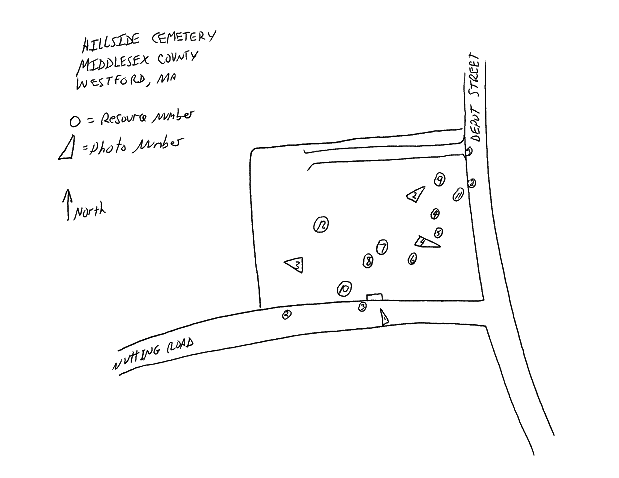
SKETCH MAP NORTH TOWARD TOP
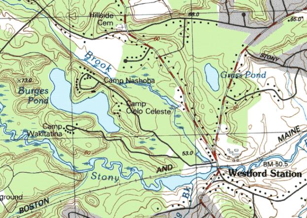
SKETCH MAP NORTH
TOWARD TOP
Wright Cemetery
Description
Introduction
The landscape layout, appearance and gravestone art of the Wright Cemetery derive from design characteristics of the pre-industrial burial grounds. These characteristics consist mainly of the slate markers and the utilitarian, formerly agricultural landscape. The burial ground was owned until the 20th century by one of the many nearby farm families named Wright. In 1909, the town Cemetery Commissioners suggested the private cemetery be cared for by the town as were Fairview, Westlawn and Hillside Cemeteries. The parcel of land including the cemetery was later given to the town. Cemetery occupants influenced the town’s history and appearance and continue to do so by virtue of their artfully carved gravestones. War veterans, mill operatives, farmers and business people occupy the approximately 150 visible historic burials.
Markers are made mostly from slate as well as from other materials. The earliest gravestones are from the Federal Period and appear in the form of shouldered-arched and flat-topped stelae (rectangular or arched tablets or slabs), the largest of which belongs to Lieutenant Nahum Wight. (Note: There are occupants named both Wight and Wright.) Monuments from the Victorian Period take the form of an obelisk and carved marble stelae. Slate continued to be used until 1854 although marble and granite were becoming more common at that time. Grave markers are mostly arranged in rows oriented east to west with inscriptions on older stones typically facing south.
Landscape
Land comprising the Wright Cemetery belonged in 1836 to Bela Wright who was granted, with some neighbors, permission by the town to keep a burial ground. The appearance at the time was likely that of a field of grass with a few small slate gravestones. The nearly square, flat, grass-covered parcel is located along the north side of a straight segment of Groton Road (State Route 40).
Boundaries of the cemetery are lined on the north, east and west with a fence four feet in height consisting of granite posts and 4”x4” rails. The Groton Road (south) boundary has a two- to four-foot high mortared fieldstone wall with split granite capstone. Entrance to the cemetery is thorough an opening in the wall at about the mid-point where a pair of stout, low granite posts support a wooden gate. Pedestrian access is through gaps beside the gate and secondary granite post. A modern flagpole occupies a site just inside the east entry. Historic burials occupy approximately ½ acre while the remaining four acres of reserve ground are in an undeveloped farm field outside the historic granite post and wood rail fence. Granite elements may have been quarried locally given the prominence of that industry in the north part of town.
Plot definition occurs in three instances with simple granite curbs. The most pronounced is approximately 24 inches in height and encompasses the Albion Wright family plot. Steps to access the plot are flanked by low pyramidal piers which also mark the corners of the plot. Other plot-defining curbs lack corner piers and rise only slightly above ground level. Curbs enclose square and rectangular plots of from eight to twenty feet per side.
Markers
The Wright Cemetery reflects trends in gravestone development in its variety of slate, marble and granite markers. Slate and marble are the oldest surviving materials used for marking burials. Slate is frequently carved in shouldered arches that range in height from one foot to approximately five feet. They can demonstrate a relatively crude, hand cut appearance, a well-designed and possibly machine cut sharpness and several levels of workmanship in between. Quality of workmanship of the slate marker is sometimes obscured by the fact that the stone has deteriorated or been broken. Inscriptions also vary in quality and detail. The simplest have fine, narrow letters with little relief or depth. Later slate stones from the 19th century are more likely to demonstrate clear, deep, stylized letters with a pronounced serif, well thought out organization relative to the shape of the stone, and a tooled finish to set off the inscription panel, ornament and banding at the edge of the stone.
Slate markers from the earliest period appear in a variety of shapes. Many are rectangular with an arched top, which may be representative of the figurative portal between life and death. The shape is also considered an abstraction of the human head and shoulders. This form of marking the passage from life is a Puritan concept brought from Boston and elsewhere during the region’s period of first settlement and endured in to the early 19th century. Eighteen slate markers exist in Wright Cemetery and have dates from 1819 to 1854. Miss Sally Stevens (d. 1848 at 43 years of age) has a typical shouldered arch-topped slate marker. It is inscribed with urn and willow motif above a central oval panel for inscription of her name and dates. Flanking the inscription are classical columns of the Doric order. This was the work of B. Day, gravestone carver from Lowell, Massachusetts.
Prior to the Federal Period, the event of death was considered a common reality whose dim portent reflected the stern view of life as a struggle for survival. Subsequently, New Englanders’ view of death adopted a sentimental quality that spoke more of the emotional state of those left behind than of the journey of the deceased, causing the replacement of darkly spiritual carvings with abstract sorrowful imagery. Urn and willow designs begin to appear on gravestones in the late 18th century and are based on classical influences exerted by the spreading glow of the Enlightenment. Both slate and marble markers exhibit this late 18th and early 19th century motif that is an icon of sorrow and grief. A highly ornamented slate marker is that of Lucy Osgood from 1854. The arched top is decorated with an urn and willow motif carved with a high level of detail including the oval background that has a hatched or tooled finish. The use of classically inspired columns in gravestone design, frequently of the Doric order, is evidence of the pervasive influence of classical imagery popularized by the Enlightenment. The stone of Nahum Wight has a design similar to Lucy Osgood’s and includes Doric columns beside the inscription panel as well as tooled finish and geometric rounds, symbols of the eternal nature of death.
Additional marker types in the form of an obelisk, Gothic designs and marble tablets with biblical and classical symbolism appeared during the Victorian Period. The single obelisk in Wright Cemetery is carved from gray granite and commemorates the lives of Joel Wright (1782-1834) and his wife Sally (d. 1869 at 79 years of age). This is the cemetery’s tallest marker at around 10 feet. Gothic themes are carved into some markers, including the pointed arched stone of Mary Wright who died in 1871 at the age of 21. Her marker has a recessed circle with inscribed flowers. Beside her grave is a small slant marker inscribed with the word “baby”, a common Victorian marker for those who died very young.
Marble markers from the mid 19th century are usually rectangular with a flat top but sometimes have a cambered (segmental arched) or pointed top. Asa (d. 1877 at 78 years of age) and Bathsheba Wright (d. 1869 at 68 years of age) have matching marble stelae with cambered tops. These three-foot high stones, which have edges set off by moldings, pendants and chamfers, are set on plinths and pedestals. Other marble tablets have tops articulated by a gradually sloping point that were erected in the mid 19th century. For example, Abbie M. Edes (d. 1859 at 15 years of age) and her relative Elvira (d. 1876) have this type of stone as does Nathan Wright who died in 1846 at 57 years of age.
20th century military stones exist in the Wright Cemetery. A small rectangular bronze marker mounted flush with the ground marks the resting place of Albert Picking (1915-1994) who served in the U. S. Army as a sergeant in World War II.
Carvers
Gravestones in the Wright Cemetery bear some identifying inscriptions by their carvers. B. Day is by far the most frequent name, appearing in around six instances. Markers for Sally Stevens (1848), Abigail Wight (1850), Nathan Wright (1846), Walter Wright (1830) and Abigail Wright (1835) were carved by Mr. Day. He worked in Lowell and craved gravestones now in cemeteries in many surrounding communities. Carvers T. Warren and D. Nichols, both of Lowell, carved the marble pointed arched stelae of Caleb Wight and Hannah Ryan from 1864 and 1863. A. Sawtell of Groton carried out the shouldered arch form with urn and willow design on Lucy Osgood’s slate marker from 1856. The Lowell shop of Andrews and Wheeler has one stone to its credit in the Wright Cemetery.
Existing Conditions
Repairs have been carried out in the cemetery on a regular basis since the 19th century, altering only slightly the appearance from its Federal Period beginnings. Slate stones are particularly susceptible to cracking and toppling given the weak structural nature of the material. Several different methods have been used to stabilize markers. There are some which have been re-set in concrete footings poured at ground level. Others have been re-attached at severed points with metal braces and bolts or cemented or glued across fractures. Both these measures were taken in order to conserve the 1846 marble marker for Nathan Wright. Most stones remain in good to excellent condition. Some slate markers are difficult to read due to erosion. While very little vandalism appears to have taken place, damage has been sustained in many cases due to scraping by lawn-mowing equipment. Few ornamental plantings remain from past landscaping efforts.
Aside from routine maintenance, repairs and some deterioration over time, few changes have occurred in the Wright Cemetery. While records do not indicate as much, it is possible that, since few remain, footstones were removed as part of past efforts to tidy the grounds. However, the large number of remaining 19th century markers makes it possible to get a clear sense of historical burial and gravestone carving techniques in Westford.
Statement of Significance
The Wright Cemetery retains integrity of materials, design, workmanship, feeling and association. It is eligible for the National Register under Criteria A and C at the local level and meets Criterion Consideration D as a cemetery which derives its significance from distinctive design features and association with historic events. The cemetery is significant under Criterion A for its association with historical events in the community such as service in the Revolutionary War and establishment of family burial grounds during the early 19th century. It is eligible under Criterion C as an example of a burial ground containing gravestone carving representative of techniques commonly used in the period. The period of significance for the cemetery begins at its establishment in 1819 and extends to 1952. It has been in continuous use.
Introduction
Westford’s Wright Cemetery first came into use around 1819, which is the time of the earliest death date on a gravestone. The town of Westford granted the privilege of a burying ground on Groton Road (then called the North Road) in 1836. Approximately two dozen stones survive from the first half of the 19th century. Gravestone ornament at the time was restrained and the surrounding landscape was allowed to appear as a grassy plot marked by slate headstones. The most basic of maintenance schedules has allowed the cemetery to retain much of its historic appearance by virtue of the densely grouped slate markers near the road, the small scale of markers and the simple landscape unencumbered by modern paths and furniture. Burials are ongoing in the Wright Cemetery.
The Wright Cemetery was the fourth of the town’s historic cemeteries to be established. Westford’s earliest cemetery was originally called the East Burying Ground and is now called Fairview Cemetery. This is on Main Street east of the town center and came into use around the turn of the 18th century. The second burial ground was the former North Burial Ground established in 1753, now called Hillside and located at the corner of Depot and Nutting Roads. The West Burial Ground or Westlawn was established in 1761 on Concord Road at Country Road. Nearly all of those interred here belonged to the First Parish Church until 1829, the time of the founding of the Congregational Church.
1819-1900
The Wright Cemetery occupies land that had been in use in the 18th century as farmland belonging to one branch of the large Wright Family. Among the founders of the cemetery was an area resident named Bela Wright to whom, in 1836, the town voted to grant “the privilege of a burying ground on the North Road, between Caleb Wight’s and Reuben Wright’s, which is to be free of expense to the town.”
Records from an early meeting of Wright Burying Ground proprietors held on June 3, 1837 and recorded in the Records of the Proprietors of the Wright Burying Ground indicate the full list of founding residents as follows: Caleb Wight, Horatio Wright, Bela Wright, Walter Wright, Martin Wright, Asa Wright, Benjamin L. Wright, Jesse L. Wright and Joel A. Wright. Votes were taken at the meeting to name Caleb Wight as moderator and Jesse Wright as clerk. Caleb Wight was determined to have care of the burying ground. A single lot was voted to be kept for burials of strangers. Caleb Wight was chosen as agent to sell lots.
There are eight gravestones with dates prior to the privilege granted by the town. These include Lieut. Nahum Wight (d. 1834 at 89 years of age), Abijah Wright (d. 1834 at 54 years of age), his wife Mary (d. 1831 at 55 years of age), Ellen Wright (d. 1830 at 28 years of age) and her children Francis and Henry who both died at less than one year of age in 1827 and 1828. Also, a single rectangular stele exists for two brothers, Jotham and Edmund Wright, whose deaths occurred in 1828 and 1819. However, this stone may be a cenotaph (a stone commemorating the death of a person interred elsewhere) since the Wright Brothers died in Dayton, (spelled Daton) Ohio and Mobile, Alabama. Jotham was a graduate of Harvard College in 1817. Other burials whose markers do not survive may also have occurred before the official establishment of the Wright Cemetery.
Gravestones from the first half of the 1800s are typically located very close together. Family members tend to be adjacent to one another, frequently aligned in the order in which they died. No segregation based on ethnicity, occupation, military service or wealth is apparent. Most stones are around the same size, two to four feet high by one to three feet wide. Maintenance of the burial ground during this period was presumably the responsibility of a Wright family member.
Nineteenth century residents of Westford who are buried in the Wright Cemetery consist mostly of farmers, several of whom were military veterans. Cemetery founder Bela Wright (d. 1859 at 62 years of age) worked as a farmer and lived 1/2 mile to the south on the current North Main Street. He also served in the War of 1812 according to notes to that effect printed in the 1896 Town Report. His relative Asa Wright (d. 1877 at 78 years of age) was also a farmer but lived in the village of Westford Center. His death was brought about by a suicide drowning according to the historian Marilyn Day in her 1998 book Westford Days. Parker Wright (b. 1791) was another occupant of the burial ground to have served in the War of 1812.
Lieut. Nahum Wight was born in Medfield, Massachusetts and served in the Revolutionary War. Lieut. Wight (also spelled White in Massachusetts Soldiers and Sailors of the Revolutionary War) served as a corporal under Captain Benjamin Bullard from Sherborn and marched on Concord in April 1775. He also served in the Continental Army at Fort Ticonderoga, among other campaigns. After living most of his life in Medfield and Sherborn, he moved to Westford, possibly to be near his son Caleb and his family. Nahum is buried next to his wife Abigail (d. 1850 at 90 years of age). Caleb Wight (d. 1864 at 77 years of age) lived in Westford Center, worked as a farmer and served as a deacon, probably in the Union Congregational Church, of which both he and his parents were founding members in 1828. Caleb Wight also served in the War of 1812. Mr. Wight is buried next to his wife Mary (d. 1869 at 80 years of age) and daughters Joanna (d. 1837 at age 24) who died at Plymouth, Michigan, Harriet (d. 1854 at age 37), Lucy Osgood (1821-1856) and Caroline (1819-1882).
The largest grave marker in the Wright Cemetery is that of Joel Wright (1782-1834) and his wife Sally (d. 1869 at 79 years of age). The grey granite obelisk is approximately 10’ high. Mr. Wright served in the War of 1812 at Boston’s Fort Warren under Lieut. Col. Jonathan Page. Approximately 100 markers from the period exist in the cemetery.
During the mid 19th century, the Burial ground had a white picket fence at its edge. The Records of the Proprietors of the Wright Burying Ground, kept from the time of the founding of the burial ground has a small number of sporadic entries thereafter. One entry indicates Ansil Davis was paid $7 for whitewashing the fence in 1847.
1900-1960
During the 19th century, the Wright Cemetery was privately owned and maintained. This is in distinction to the East (now Fairview) West (now Westlawn) and North (now Hillside) Cemeteries, which since at least 1840 had received care by a neighbor at the expense of the town. In 1909, the Cemetery Commissioners noted in the town report that “Parties interested in the private cemetery called the Wright Cemetery at the north part of the town have expressed a wish that the town assume the care. Your commissioners recommend it be done”. No caretaker is specified in town reports for the Wright Cemetery, as was done for other cemeteries, until the middle of the 20th century. However, military veterans in the cemetery did receive commemorative markers at the expense of the town starting around 1909. Since scant mention is made in public records, it is difficult to determine the date of construction for the ashlar granite wall that separates the cemetery from the road or names of those who may have built it. This is also true of the granite post and wood rail fence surrounding the cemetery.
World War II veterans are buried in the Wright Cemetery, at least one of which has a military marker. Albert H. Picking (1915-1994) served in World War II and is buried under an arched granite slab. His military service is as a sergeant in the Army is remembered by an adjacent bronze tablet mounted flush with the ground. He is buried with his wife Bernice Picking (1915-1996). Mrs. Picking lived her entire life at the farm ¼ mile to the west of the Wright Cemetery.
Interments continued throughout the period with granite being the gravestone material of choice. The 1937 town report includes a sample contract for purchase of burial plots that indicates no walls, fences, curbs or projecting corner posts were allowed, probably to simplify maintenance. This regulation, instituted by the Cemetery Commission, served to stem the installation of new ornament in cemeteries and to encourage removal of furnishings that may have been installed in the Victorian Period, although no such activity is documented. Sebastian Watson, Fred Blodget and Axel Lundberg served the town as cemetery commissioners from at least 1937 though 1949. Town employees performed work at the cemetery in 1960 that included painting and repairing the fence, cutting brush and planting new shrubs. Few ornamental plantings remain.
Conclusion
Colonial, Federal and Victorian period historical associations of the Wright Cemetery are largely intact despite interruptions by the small number of modern markers and the smaller amount of documentation compared to the town’s other cemeteries. The possibility remains, by observing the rows of arch-topped slate stones carved with urn and willow designs, classical columns, and by recalling names so important to the development of the community, to get a strong sense of how 19th century residents of the Town of Westford experienced their burial places.
A diseased elm tree was cut down in 1963. The existing gate was installed with original hinges and nails in 1975 during the Bicentennial period when all of Westford’s cemeteries were recognized as important resources for the historical appearance they retained and for the accomplishments of the Westford residents interred there. The stone in the wall with the inscribed name was given to the town by Carl Wright in 1977.
Geographical Data
Verbal Boundary Description:
Wright Cemetery comprises all of the land within the boundaries of the cemetery. It is bounded by Groton Road on the south. The cemetery encompasses 4.5 acres, described by the assessor’s office as parcel 5 on map 35.
Boundary Justification:
Boundaries of the cemetery were determined by the Westford Historical Commission and by the consultant. Boundaries include all gravestones, burial-related buildings, structures, circulation paths and ornamental plantings. Stone walls encircle the cemetery and mark all boundaries.
SKETCH MAP NORTH
TOWARD TOP
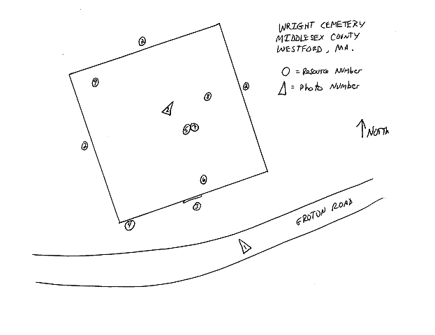
SKETCH MAP NORTH TOWARD TOP
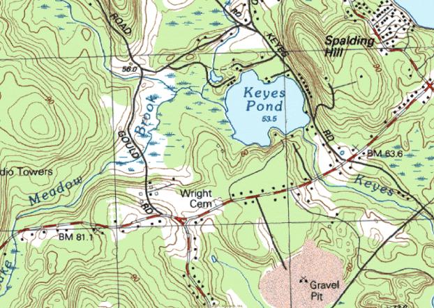
SKETCH MAP NORTH TOWARD TOP
Russian Cemetery
Description
Introduction
The landscape layout, appearance and gravestone art of Westford’s Russian Cemetery derive from design characteristics of the Early Modern Period with a Russian Orthodox religious influence. These characteristics consist of the flat, utilitarian landscape and, more importantly, the markers that are made primarily of granite, approximately 15 of which have free-standing crosses on top carved from stone. Many others are inscribed with distinctive Russian orthodox crosses. Land of the cemetery was privately owned until 1918 when the need was felt for a burial place for immigrant factory laborers who were mainly of Russian origin. A small number of interments are of immigrant laborers of Polish and other origins. Many of the approximately 300 Westford residents interred here were recruited as teenagers and young adults at their Russian and European villages for work in Westford’s mill villages by traveling company operatives. Approximately 50 stones bear death dates between 1918 and 1960. The immigrants influenced the town’s history and appearance and continue to do so by virtue of their artfully carved gravestones. The burial ground is located on the north side of Patten Road.
Markers are made almost exclusively from grey, pink and black granite with one cast concrete example. The earliest markers are from the Early Modern Period and appear in the form of nearly square tablets on a square plinth, occasionally with crosses mounted on top. Many inscriptions, including those on the earliest and largest markers, are in the Cyrillic language. Other markers have English language inscriptions with simpler stone designs in the form of rectangular tablets which lack the free-standing cross. Grave markers are arranged in rows oriented approximately north to south with inscriptions typically facing west.
Landscape
Land comprising the Russian Cemetery belonged in the 19th century to the Blood family and later to the Read family. The flat, nearly square parcel was likely in use as farm land at that time. Entrance to the cemetery is through two gateways in the stone wall along the Patten Road (south) side. Gateways along the southerly edge are flanked by a pair of stout, low ashlar piers with cast stone pyramidal caps. The three-foot high stone wall is split granite ashlar with a capstone. Plot-defining features inside the cemetery, such as granite curbs or plot corner stones, do not exist. Circulation among graves is via a U-shaped asphalt driveway that enters and exits from Patten Road.
Markers
The Russian Cemetery is characterized mainly by its granite tablets, the most ornamental of which are topped by a free-standing Latin cross cut from granite. Ranging in height from three feet to approximately six feet, this type of marker is articulated in approximately 15 cases with a Cyrillic language inscription. Those written in English are simple in language and basic in detail. Typical inscriptions have names and dates rendered in a simple style of script. The earliest marker has a square plinth with nearly square black granite tablet on top which bears the Cyrillic inscription and the death date of 1918. Ornament consists of the free-standing Latin cross inscribed with the letters IHS. Other markers have the square tablet on the plinth with no free-standing cross. More recent markers are simple rectangular tablets with low arched tops.
Examples of grave markers with the free standing cross include that of George (1887-1946) and Annie (1896-1991) Butko. The cross on this grey granite example is inscribed with letters IHS which stand for "Jesus" or “In His Service” or "He Is Risen". Matrona (1890-1933) and Andrew (1882-1956) Prowker and their child Antonia (1912-1927) have a grey granite tablet with free standing cross inscribed in the same way. Many other such markers have Cyrillic inscriptions. Some black granite examples exist. Most others are grey and blond in color.
Markers exist which lack the free standing Latin Cross but bear the Russian Orthodox Cross as part of the inscription. The Russian Orthodox Cross is unusual because it has three bars instead of the more common single bar as seen in the Latin Cross. The top bar is narrower than the others and bears the title board in detailed versions. The middle bar is the widest of the three and is the one on which the Lord’s hands are nailed. The bottom bar is not only narrower than the middle but is oriented at an angle to the central stem. This is the bar on which the Lord’s feet are at rest. Markers in the Westford Russian Cemetery with the Russian Orthodox Cross inscribed in the low arched top of the tablet include the pink granite marker of Matthew Sudak (1896-1951), the grey granite stone of Luke (1893-1974) and Mary (1891-1945) Archinski, the wider pink granite arch topped marker of Peter (1886-1956) and Alexandra (1896-1953) Talanetz as well as many other similar examples. The Latin Cross also appears as the main ornamental component in the inscription on some stones.
Military and Commemorative Markers
20th century military markers exist in the Russian Cemetery. A small rectangular bronze marker mounted flush with the ground marks the resting place of Alexander Belida (d. 2001) who served in the U. S. Army Air Forces as a sergeant in World War II. A granite example of the flush military marker is that of Nicholas Sudak Jr. (1917-1984) who served in World War II as a staff sergeant. The stone is ornamented with a cross inscribed in a circle. Approximately a half-dozen similar examples exist.
Gravestone Carvers and Manufacturers
Gravestone manufacturers identified their work in some cases by attaching metal tags to markers. Pre-1960 stones with identifying tags include the 1933 example of Matrona and Antoni Prowker which bears a bronze tag stamped “Lowell Monument Co., manufacturers, Lowell, Mass”. Mary and Steve Belida’s 1951 stone has a tag stamped “Luz Brothers, 1022 Gorham St., Lowell, Mass.” This stone is also etched with the “Barre Guild” seal, signifying the monument as a product of the Barre Granite Association of Barre, Vermont. Locally made markers include that of Demitry and Vera Belida’s 1960 stone made by the Barretto Monument Company of Groton Road in Westford. Peter and Mary Worobey’s 1941 marker was sold by A. G. Lundberg of Westford. This is Axel G. Lundberg, Cemetery Commissioner in the 1930s and 1940s who had a granite shop on Brookside Road. Other stones were purchased from University Monumental Works on Berkshire Street in Cambridge. Stones from this period appear to be pre-manufactured stones with stock designs created prior to purchase.
Existing Conditions
Most stones remain in good to excellent condition. Very little vandalism appears to have taken place. The single cast concrete grave marker has no inscription and it is impossible to discern whether or not it had one that is now lost. Boundaries of the cemetery are marked by modern chain link fence on the east and west sides with a wire fence supported by stakes on the north or rear edge. A modern flagpole rises from the northern section.
Few changes have occurred in the Russian Cemetery since its inception in 1918. The large number of remaining markers with Cyrillic language inscriptions and the proximate birth dates of the occupants who arrived during a short span of time in the early 20th century make it possible to get a clear sense of local trends in immigration and factory employees’ ethnicity in Westford. This is the only historic cemetery in the town dedicated to a group with particular national affiliation. A Catholic cemetery exists on Pine Ridge Road.
Statement of Significance
The Russian Cemetery retains integrity of materials, design, workmanship, feeling and association. It is eligible for the National Register under Criteria A and C at the local level and meets Criterion Consideration D as a cemetery which derives its significance from distinctive design features and association with historic events. The cemetery is significant under Criterion A for its association with events in the community such as immigration by factory workers. It is eligible under Criterion C as an example of a burial ground containing gravestone designs that are unusual in the community. The period of significance for the cemetery begins at its establishment in 1918 and extends to 1952. It has been in continuous use.
Introduction
Westford’s Russian Cemetery first came into use in 1918, primarily to accommodate burials of immigrant mill workers from that country. Significant numbers of Russian immigrants began to arrive in Westford during the first decade of the 20th century as the result of recruiting efforts by mill company agents in Belarus as well as other regions of Europe. The cemetery remains in use today, largely by descendants of mill recruits. Some Polish immigrants accompanied the Russians to Westford’s mill villages and are interred here as well. The history of Westford’s mill villages includes periodic trends in immigration of several ethnic and national groups starting with the Irish in the 1840s. French Canadians also arrived in large numbers as did residents of Sweden, Italy, Scotland, England and other nations. While Catholics of many nationalities did choose to create a cemetery of their own in the town, no other ethnic or national group in Westford has as important and distinct a resource as the Russian Cemetery to symbolize their history in the town. The cemetery provides information concerning not only names and dates of individuals interred therein but contextual documentation of the typical immigrant in terms of age and marital status. The cemetery itself stands as a testament to the solidarity of Westford’s Russian immigrant population.
1918-1960
Ethnicity and national origins of residents of the town underwent change during the mid-late 19th century from a mainly native-born group to one of significant foreign-born population. Residents were almost entirely of English descent until 1850 when census records show the first Canadian and Irish immigrants. In the 1865 state census, approximately 20% of the residents were foreign-born. By the end of the century the percentage of foreign-born residents was more than half according to Annual Town Reports. Federal census figures from 1910 confirm the dramatic increase in the number of foreign-born Westford residents around the turn of the century. Groups of nationalities with representatives numbering in the hundreds include Canadians, Russians, Italians and Irish. Smaller groups were Swedish, Scottish, Austrians and English. In 1907, Russians begin to appear on lists of Westford residents and in marriage records.
In 1912, agents of the Abbot Worsted Company traveled to the Russian region of Belarus and the city of Grodno in order to recruit additional laborers with the promise of steady work, good housing and prepaid travel expenses. The agents’ success and a sudden increase in Russian residents is reflected in census information and is confirmed in reminiscences of former Abbot Worsted employees. Census information reveals that Russians were most likely to be listed as woolen mill employees as opposed to Italians in Westford who were most commonly described simply as laborers. Every resident in the resident directory for 1920-21 with a Russian surname was employed by either the Abbot or the Sargent mills in Forge Village or Graniteville although it is suggested by current residents that some members of the group also worked in stone quarries in the north part of town. The Abbot Worsted Company manufactured woolen yarns in Forge Village and Graniteville with machinery made in Graniteville by the C. G. Sargent & Sons machinery manufacturing company. Based on gravestone inscriptions, it is apparent that the immigrants were between 16 and 31 years of age at the time of embarkation to America.
Grodno is located in northwest Belarus, bordered on the north by Lithuania and on the west by Poland. The population was largely Byelorussian, Lithuanian, and Polish, some of whom immigrated along with their Russian neighbors. Industrial products in Grodno were diverse and included textiles. According to a Grodno municipal website, there were in 1897 over 100 residents involved in manufacture of textile fabrics which may have been influential in the Westford mill company agents’ selection of the region for labor recruits. Since working conditions in the Russian factories were distasteful and included long hours and poor pay, Abbot Company employees achieved success in their efforts to swell the ranks of mill hands in Westford’s modern, well-managed facilities. The Abbot Worsted Company also mounted successful efforts to entice Canadian emigrants from Trois Rivieres in Quebec and English workers from the city of Keighley in Yorkshire.
Russian Cemetery occupants appear to have been married either before they arrived in America or to have married fellow immigrants judging by the ethnic tone of the given names of many couples in the Russian Cemetery. It is noteworthy that nearly all were married one time. Residents whose spouses died earlier than themselves tended not to remarry as did members of other groups.
One of the many benefits for immigrants was the availability of English language classes, which were held in the Abbot Worsted Company-built social halls, two of which were located in Graniteville on Cross Street and on North Main Street. Other company social halls were in Forge Village on Bradford Street and in the Brookside Village (MHC ) on Brookside Road. Immigrants occupied the rented single and multiple dwelling-unit houses in mill neighborhoods in increasing numbers until the mid 20th century when the wool industry in New England had entered decline. During that time, residential subdivisions had been built on Abbot, Palermo, Orchard, Pine, Lincoln, Elm, Smith and Pershing Streets in Forge Village and River, First, Second, Third and Fourth Streets in Graniteville, among others. All these residential streets were home to Russian mill employees.
Russian immigrants who occupy the cemetery and whose names can be matched to residents on voting lists and resident directories from the 1920s and 1930s include Forge Village residents Peter Britko (1894-1977) and his wife Alexandria (1894-1957) at 7 Canal Street from 1924-1928; Peter Talanetz (1886-1956) and his wife Alexandra (1896-1953) at 8 Canal Street in 1924 and 6 Palermo Street in 1928; Peter Worobey (1891-1991) and his wife Mary (1893-1941) at 2 Canal Street in 1920-1928; Michael (also Mika) Salaliko (1881-1956) and his wife Marcella (1885-1934) at 6 Canal Street in 1924; Stephen Harachko (also Harachka, 1884-1976) and his wife Dominika (1890-1969) at 21 Chestnut Street in 1924 and 25 Chestnut Street in 1928; Jacob Tereshko (1896-1987) and his wife Axzenia (1893-1965) at 15 Oak Street in 1924 and 1928. Wasil Beskalo (1890-1969) and his wife Fedora (1895-1980) lived in Graniteville at 17 First Street from 1921 to 1928.
Conclusion
The Russian Cemetery evokes the heritage and cemetery design practices of a major group of immigrants to the town. The Russian immigrants’ group history can be related by observing the gravestones with their proximate birth dates and names that are so unusual compared to those of English descent in other cemeteries in the town. The unusual appearance of the gravestones with the free-standing crosses on top combined with the Cyrillic letters, altogether unusual in Westford, further distinguish the cemetery from others in the town. These differences are a reflection of part of the broad spectrum of the community's history and culture. Survival of the cemetery is the most significant reminder of this important element of local culture.
Geographical Data
Verbal Boundary Description:
The Russian Cemetery comprises all of the land within the boundaries of the cemetery. It is bounded by Patten Road on the south. The cemetery encompasses 1.33 acres, described by the assessor’s office as parcel 27 on map 54.
Boundary Justification:
Boundaries of the cemetery were determined by the Westford Historical Commission and by the consultant. Boundaries include all gravestones, burial-related buildings, structures, circulation paths and ornamental plantings. Stone walls encircle the cemetery and mark all boundaries.
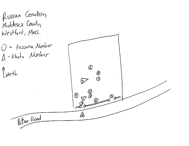
SKETCH MAP NORTH
TOWARD TOP

SKETCH
MAP NORTH
TOWARD TOP
John Proctor House, 218 Concord Road
Description
The John Proctor House, Westford, Massachusetts, is a well-preserved, late First Period house of timber-frame construction (ca. 1720-1740) that has been enlarged by a two-story addition at the west elevation (ca. 1840-1870) and a one-story rear wing (ca. 1870-1910). Originally built as a center-chimney dwelling, the John Proctor House was modified in the early eighteenth century by the removal of the original western bay and now stands as a half-house.
Surrounded by fields and woods, the John Proctor House stands on its original site facing south across Concord Road, a main transportation route established prior to or during the early seventeenth century. Immediately adjacent to the house are a modern garage and a cellar hole, elements of which may date from a nineteenth century barn (although concrete facing suggests twentieth-century rebuilding). The surrounding vicinity is rural and consists of scattered former farmsteads, over 100 acres of conservation land, and some recently built homes which are not visible from the nominated property.
The John Proctor House rests upon a low fieldstone foundation. The exterior elevations are covered with wooden clapboards and are trimmed with simple flat-board friezes and corner boards. Similarly, the front entry and the window surrounds feature flat-board casing. Due to the removal of the original western bay in the early nineteenth century, the main entry is positioned asymmetrically towards the west and stands above the façade’s gabled roof, and its slight eave is decorated with a boxed cornice and cornice returns. A narrow brick chimney stands at the west elevation (north of the windows), and a second chimney pierces the front-gabled roof of the north elevation addition.
The sparse fenestration of the John Proctor House façade is typical of the First Period design. It consists of one 6/6 double-hung sash window east of the entry at the first story, one 6/6 double-hung sash window at the east bay of the second story, and one smaller 4/4 double-hung sash window positioned over the entry. The top rails of both second story façade windows intersect the frieze, which may be due to the presence of earlier casement window openings, which were enlarged during the nineteenth-century installation of larger double-hung sash windows.
The John Proctor House consists of two bays, one is framed into a former chimney bay (west, approximately 9’ wide) and the other is a room bay (east, approximately 18’6” square). Framing members consist of flared oak posts, large girts, and boxed plates. The floors of the main house are supported by a transverse summer beam (13” x 12’6”) at the first story and a square longitudinal boxed summer beam (15’6”) at the second story.
The attic is framed into three bays by principal rafters that rise to a small ridge-pole which has been replaced at the western bay (original chimney location); purlins are irregularly spaced and bear evidence of alteration with salvage materials. About 1900, a one-half story balloon-frame rear ell was added; interestingly, the ell is butted against the north elevation without altering or being tied into the house’s original frame.
Most of the present interior woodwork and plaster of the John Proctor House appear to date from the second quarter of the nineteenth century. The wall thickness at the façade (10”) and rear wall (11 ½”) suggest that current finishes have been applied over earlier finishes. The 6” thickness of the west side wall reflects its alteration in the nineteenth century; the east side wall is only 6” thick at the first story, as a result of the replacement of its sill and studs in the first half of the twentieth century.
Richard and Alan Emmet, who have owned the house since 1970, have undertaken some basic repairs and maintenance; the John Proctor House and surrounding acreage, however, survive remarkably intact. The nominated property includes 1.16 acres of land surrounding the John Proctor House, with 247.68 feet of frontage on Concord Road and a northern lot line of 217.92 feet. The Emmets have donated the remaining acreage of the John Proctor House premises to the Massachusetts Audubon Society as part of a larger tract which is a designed wildlife sanctuary.
Historical Physical Appearance
The main house (ca. 1720-1740) was built by John Proctor II (1694-1783) of Westford, Massachusetts. Although originally constructed as a center-chimney, timber-frame house, early deeds from John Proctor II to his sons, Phineas Proctor and John Proctor III, refer to divided use and ownership among family members of the eastern and western sections.
In 1791 a Proctor descendant, James, sold a large tract of the Proctor Farm and the eastern half of the John Proctor House to a non-family member, while Sarah Wright Proctor (the widow of John Proctor II) continued to live in the western section of the house until her death in 1827. The John Proctor House was physically reduced to a half-house in 1827 when the western section was sold to Henry Fletcher, a neighbor. Two flared posts used as plates in an 1827 addition to Henry Fletcher’s barn offer evidence that framing elements of the Proctor House may have been re-used in this location.
Deed references indicate that Henry Fletcher probably dismantled a large center chimney along with the western bay of the John Proctor House in 1827, requiring the owner of the remaining eastern section to undertake major changes in order to live in the divided structure. At this time, a smaller chimney (now capped below the roof line) was constructed at the west elevation and set 4’ into the former hall and hall chamber area in a position slightly east of the original chimney.
A small room was created in the former center-chimney bay, and it is likely that the west elevation addition was constructed ca. 1840-1870 to create usable rooms at the first and second stories of the house’s west end. Other changes made at that time probably include the enlargement of existing window openings to their present dimensions and the cutting of new windows on the house’s east end. The present exterior boxed cornice was likely added between 1830 and 1850.
In 1874 Lizzie Martin of Boston purchased the John Proctor House and 12 acres of land for $1,100. In 1881 Mrs. Martin and her husband Frederick purchased a 30-acre parcel abutting the house to the east and north. (This property adjoined the west boundary of the Henry Fletcher homestead.) In 1885 Mrs. Martin was taxed on a house, shed, barn, and 42 acres; by 1895 a henhouse existed on the premises as did 1 horse, 4 cows and 20 fowl.
As noted, the John Proctor House’s balloon-frame rear addition was built ca. 1900, and it appears that John Martin, son of Lizzie and Frederick Martin, and his family lived on the premises around this time because his wife Clara was listed as the owner of record on a 1915 tax assessment. It is believed that the Proctor Barn collapsed or was torn down prior to 1951, and a low metal-roofed shed (now removed) was built over the barn’s fieldstone foundations.
After Mrs. Clara Martin died in 1959, her two unmarried sons, John and Clarence Martin, lived on the premises until 1970 when they sold the John Proctor House and 42 acres to Richard and Alan Emmet. The Emmets, who have lived in the neighboring Henry Fletcher House since 1951, continue to own the John Proctor House and rent it to residential tenants.
Statement of Significance
The John Proctor House, initially constructed between 1720 and 1740, is important for its surviving elements of First Period architecture in addition to the well-preserved, mid-nineteenth-century interior finishes and exterior elements, resulting from modifications made between 1827 and ca. 1850. The house also possesses historical associations with the family of Robert Proctor, one of the first settles of Westford. The John Proctor House retains a high degree of integrity of setting, location, feeling, design, materials, and association which are further enhanced by an architecturally significant dwelling retaining original materials and workmanship exemplifying traditional construction during Westford’s earliest period of settlement and reflecting nineteenth-century building practices in Westford. The John Proctor House thus fulfills National Register Criteria A and C on the local level.
Originally the hunting ground of the Pawtucket, Wamesit, and Nashoba Indians and formerly the “West Precinct” of the Town of Chelmsford, Massachusetts, the Town of Westford is located 24 miles northwest of Boston and 7 miles southwest of Lowell in the northern section of Middlesex County. Westford’s boundaries encompass 31 square miles, comprised mainly of rolling upland terrain with numerous brooks, ponds and bogs. English colonial settlement began in the mid-seventeenth century. The first settles came mainly from the nearby towns of Concord, Woburn, and Wenham to obtain land, clear trees, build homes, and begin farming. The Nashua Valley corridor supported an agricultural economy and the water power of Stony Brook gave rise to local mill sites. Settlement was interrupted in 1675 by King Philip’s War. Re-settlement proceeded slowly, and Westford remained part of Chelmsford, Massachusetts, until 1729 when acting Governor William Dummer signed an Act of Incorporation for the Town of Westford. Shortly thereafter, the boundaries of Westford were enlarged by the annexation of the Prescott, Kent, and Townsend family estates, which were previously part of the Town of Groton.
Between 1720 and 1800 Westford continued to exist as a farming community of scattered farmsteads situated on pre-established transportation routes. During this time, a town center also began to grow around the town common, the first Meeting house, and the town cemetery. In the early nineteenth century, the water power of Stony Brook lead to development of several small-scale industrial centers (Nabnasset, Graniteville, and Forge Village), and granite quarrying began in the northeast section of Westford in 1820. In 1855 the Abbot Worsted Mills, located first in Graniteville and later in the Forge Village area of Westford, began the manufacture of worsted yarns and attracted immigrants to Westford from England, Scotland, Canada, Ireland, Russia, Poland, and Italy.
With increasing competition from large upstate New York and Mid-west farms, New England’s overall agricultural productivity began to decline in the early nineteenth century. Westford’s long-established agricultural economy improved, however, during the Civil War era, and agriculture remained one of the primary occupations of Westford residents until after World War II. Dairy farming was predominant; although fruits such as apples, peaches, and strawberries were also sold profitably at Boston markets.
Due to the eventual decline of Westford’s agricultural economy in the 1950s and 1960s, many local farmers sold land to developers who were building new homes to accommodate Boston’s suburban expansion. Although Westford’s town center, mill villages, and some agricultural landscapes presently remain intact, increased access to the Boston highway system (via the extension of Interstate 495) and industrial expansion of surrounding communities have brought extensive suburban development to Westford during the past 20 years with consequent loss of former farmsteads and agricultural lands.
The nominated property, a two-story, timber-frame house, was built ca. 1720-1740 by John Proctor II (1694-1783), husbandman. John Proctor II was the grandson of Robert Proctor, a petitioner to the General Court in 1653 for the settlement of Chelmsford Plantation. When Robert Proctor moved from Concord, Massachusetts, to the “West End” of Chelmsford with his wife Jane Hildreth Proctor; and their four children between 1650-1656, the Proctors became one of the first families to settle the area and to begin farming. Robert and Jane Proctor had seven additional children’s births indicating that they remained in Chelmsford at least until the early 1680s.
In 1692 and 1693, Robert Proctor conveyed much of his property to his son John Proctor I, including among other parcels his “home Lott with a Dwelling house, Barn and other out houses Lands, Meadows & orchards” and a “parcel of Land called ye New Lott… bounded Southerly by the Highway…” Robert Proctor’s movable property was also included in the transfer “Excepting Such Cattle and household goods… reserved in another Instrument” and the right to cut wood on the east side of “the Ry Lott.” As all other parcels are described as meadows and woodlots, it is possible that the “New Lott” was already the home of John Proctor I and his wife, Miriam Proctor, at the time of transfer.
That the “New Lott” of Robert Proctor may have been the property at 218 Concord Road is possible but conjectural due to the imprecision of property descriptions and the lack of subsequent deeds until 1760 when John Proctor II sold several parcels to his son, Phineas Proctor. Included in the 1760 sale was a parcel of land that corresponds to 218 Concord Road together with one-half of the “Dwelling House & Barn” standing thereon. As John Proctor II was married prior to 1719 and was living in Westford at the time of its incorporation in 1729, it is probable, but not documented, that the present main house was standing by the 1720s.
Subsequently, in 1761 John Proctor II sold additional parcels to his son John Proctor III, yeoman (1733-1785). This sale included one-half of the house and barn of John Proctor II but apparently not the land on which they stood, as it had already been sold to Phineas Proctor. From 1761 to 1827 the western half of the house was occupied by the family of John Proctor III and the surrounding acreage was farmed. In the initial settlement of Proctor’s estate, the western half of the house and nearby land were granted to his widow, Sarah Wright Proctor; an inventory of the estate includes two sets of fire shovels and tongs with sufficient furniture to indicate that Proctor occupied at least two rooms and perhaps more. The inventory also lists the farm implements, livestock, and cooper’s tools that belonged to John Proctor III.
In 1782 the eastern half of the house and the land on which it stands were sold by Phineas Proctor, husbandman, to his son, James Proctor, yeoman. This conveyance also included 76 acres of land used for “orcharding mowing, plowing and woodland.” In 1798 James Proctor sold the eastern half of the house and an 80 acre farm to Abel White of Westford for $850, subject to a $400 Bank Mortgage. Between 1802-1819,ownership of the eastern half of the house with 12-acre tract of land changed hands several times before being acquired by in 1819 by Samuel Farwell, a cooper from Littleton.
Sarah Wright Proctor, the widow of John Proctor III, continued to live in the western section of the house until her death in 1827. Following the death of Sarah Proctor, the land that Phineas Proctor had purchased from his father was sold in 1827 to Henry Fletcher, the owner of neighboring property. Henry Fletcher also purchased the “West part of the House as far as the Senter of the chimney with the Sellar under the same—with ten feet wide in the southwest corner of the Barn Beginning at the floorway through to the West End with a privilege in the Thrashing floor.”
Insofar as the description of Fletcher’s purchase indicates that the John Proctor House was a full, center-chimney structure, rather than the present half-house, it suggests that Fletcher dismantled the chimney and western bay of the John Proctor House, requiring the owner of the eastern half to make major changes to the remaining structure. The use of two flared posts as plates in a 1827 addition to Henry Fletcher’s barn offer evidence that framing elements of the Proctor House may have been re-used in this location.
As noted, beginning in 1819 Samuel Farwell owned the eastern section of the John Proctor House and its 12 acre parcel. Farwell had married Mary Parker in 1813 (Mary Parker Farwell was a member of the established Westford family for which “Parkerville,” now “Parker Village,” was named) and, as discussed above, it appears that the Farwells modified both the exterior and interior of the house during the second quarter of the nineteenth century (1830-1850) in order to render the half-house more comfortable and attractive.
Even though Samuel was a cooper by trade, the Farwell family continued the tradition of farming; Mary Parker Farwell purchased an additional, non-abutting 30 acre parcel to the west of their home for this purpose in 1850. Samuel Farwell died in 1859, survived by his wife Mary and five grown children. The inventory of Farwell’s estate listed a house, barn, and land with personal property that included household furniture, dairy tools, two lots of casks, farming tools, three cows, one wheelbarrow, one lot of hay, and $100 in cash.
Beginning in 1866, the John Proctor House and 12 surrounding acres were sold three times before being purchased in 1874 by Lizzie Martin of Boston, Massachusetts. During this time, the John Proctor House continued to be a family farmstead, and Mr. and Mrs. Martin expanded their holdings in 1881 by purchasing a 30 acre parcel which abutted their house to the east and north and adjoined the west boundary of the neighboring Henry Fletcher House premises. Additionally, chicken and egg production became commercially important in Westford during the end of the nineteenth century, and by 1895 the Martins had constructed a henhouse to for their 20 fowl.
In 1915 Mrs. Clara Martin, the daughter-in-law of Lizzie and Frederick Martin, was the property’s owner of record on the local tax rolls. Successful farming continued into the early twentieth century, and the Martin family held 42 acres of land, the John Proctor House and Barn, a henhouse, a horse and cow, plus 30 fowl. The advent of the 1930s brought economic depression and a decline in farming in Westford. Active farming probably ceased on the property by the late 1940s, and it is believed that the Proctor Barn collapsed or was torn down prior to 1951. Clara Martin died in 1959, and her two unmarried sons, John and Clarence Martin, used the premises for residential purposes. In 1970 the Martins sold the John Proctor House and 42 acres to its current owners, Richard and Alan Emmet, who rent the house to residential tenants.
The Emmets donated a perpetual preservation restriction to the Society for the Preservation of New England Antiquities in 1990 in order to ensure that the historical and architectural integrity of the John Proctor House will continue to be preserved for generations to come. The restriction protects both interior and exterior features of the house, such as the foundation, all elevations, roof profiles, structural members, interior space configuration, floors, plaster walls and ceilings, woodwork and fireplaces.
The John Proctor House is significant as a rare survivor from the early colonial period of Westford, Massachusetts, and for its associations with Robert Proctor, who was one of Westford’s first settlers. Due to its well-preserved condition, the house contributes to the understanding of late First Period design and construction practices in Middlesex County and stands as an uncommon example of an eighteenth-century, center-chimney dwelling that was reduced to a half-house more than 100 years later. Built on an early transportation route, the John Proctor House and its intact setting also exemplify the agrarian life-style of many Westford residents between the eighteenth and early twentieth centuries.
Geographical Data
Verbal Boundary Description
The nominated property consists of Parcel A (1.16 acres) with the John Proctor House thereon, as more particularly described in a survey conducted June 10, 1991, by McGlinchey Associates, Inc. (attached as a site plan):
Parcel A Southerly by Concord Road two hundred forty-seven and 68/100 (247.68) feet;
Westerly by land now or formerly of Richard S. Emmet, Jr. two hundred ninety-eight and 93/100 (298.93) feet;
Northerly by land now or formerly of Richard S. Emmet, Jr. by several lines measuring together three hundred sixty-eight and 66/100 (368.66) feet; and
Easterly by land now or formerly of Richard S. Emmet, Jr. one hundred forty-eight and 45/100 (148.45) feet.
Boundary Justification
The boundaries of the nominated property include the immediate environs of the John Proctor House contributing to the historic integrity of the premises. The boundaries also reflect the creation of a 1.16-acre parcel surrounding the John Proctor House by its current owners, who have established preservation restrictions on this lot and have donated the remaining acreage to the Massachusetts Audubon Society.
Henry Fletcher House and Barn, 224 Concord Road
Description
The Henry Fletcher House, Westford, Massachusetts, is a two-story, five-bay, timber-frame dwelling of late-Georgian design with a rear ell and several twentieth-century additions. To the east of the house stands the Fletcher Barn, a two-story, timber-frame structure of two bays’ length; it possesses a main core contemporary with the Fletcher House’s initial period of construction (ca. 1810-1813).
Both the Henry Fletcher House and Barn stand on their original sites facing south across Concord Road, a main transportation route established prior to or during the early seventeenth century. The grounds, which include approximately 10.6 acres of land lying to the north and south of Concord Road, feature open fields, second growth woodlands, and low stone walls. The surrounding vicinity is rural and is comprised of scattered former farmsteads, over 100 acres of conservation land, and some recently built homes which are not visible from the nominated property.
The Henry Fletcher House was built in several stages and consists of a two-story main house (ca. 1810-1813); an extensively modified one-story rear ell (ca. 1810-1820, sections ca. 1860-1880, ca. 1950-1970); a two-story rear addition (ca. 1960); a bathroom addition to the west elevation (ca. 1970); and a glazed east porch (ca. 1978).
The main house rests upon a dry wall stone foundation which appears to have been re-faced with granite during the early nineteenth century. The exterior of the main house is covered with clapboards (south and east elevations) and painted shingles (west and north elevations).
The façade of the house is symmetrically arranged around a center entry. The entry consists of a raised six-panel door and a four-light transom set in a well-preserved, pilastered surround which rises to an undecorated frieze and cornice. Elsewhere, exterior details consist of narrow corner boards, a shallow molded cornice, and a wide wooden water table.
The fenestration of the main house remains as originally designed, although the current 9/6 sash is a replacement (ca. 1920-1940) for the earlier 6/9 sash, which is shown in an old photograph of the house. Dating from a similar period of alteration are the façade’s dormers (now removed) and the painted wooden shingles that conceal the clapboards with which the house was previously covered.
The main house possesses a characteristic vernacular floorplan of rooms laid out around a central chimney with three fireboxes at the first story and two at the second. As originally laid out, the first story of the main house possessed two principal rooms flanking the chimney (east and west) and a kitchen with service rooms along the north side of the house; a similar original floorplan is attributed to the second story. Changes have been made to partitions and finishes in the rear (north) rooms of the first and second stories, while the principal rooms and main stairwell remain largely undisturbed.
The main house’s interior retains its original fireplaces, bake ovens, paneled doors, plaster walls, raised paneling, and other finishes that bear a mixture of late-Georgian and Federalist style motifs. Especially well-preserved finishes remain at the main stairhall, with its scalloped stair treads and low railing, and at the southeast chamber, whose mantelpiece is derived from Plate 20 of Asher Benjamin’s Country Builder’s Assistant of 1797.
The one-story rear ell of the Henry Fletcher House retains the timber-frame construction of an original or early service ell and extends eastward from the northeast corner of the main house. The ell currently serves as the dining room and possesses a series of wrought-iron hooks set into its ceiling that remain from the mid-nineteenth century. As noted, the more recent additions to the house’s west, north, and east elevations date from the twentieth century, and their scale and materials are compatible with the earlier fabric of the main house.
The Fletcher Barn is a two-story, timber-frame structure of two bays’ length and is contemporary with the Fletcher House’s initial period of construction (ca. 1810-1813). The barn’s design is characteristic of an “English” barn, with its principal door located in the side gable of the south elevation. The core of the barn has been expanded laterally by a one-bay addition to the western end. This addition is likely to have been constructed in 1827 when Fletcher dismantled a section of the neighboring Proctor House and re-used the timbers in this location. A balloon-frame hen house (ca., 1930) is located at the east gable end.
The Fletcher Barn rests upon a fieldstone foundation, and its elevations are clad with wooden shingles. In its present form, the barn retains lofts, as well as elements of cow stalls and other minor partitions from its use as a livestock barn. Alterations to the building include the installation of shingles with wide exposure to the weather (ca. 1920-1940) as well as the addition of two garage doors and internal partitions to create a separate parking area for two cars. These modifications do not interfere with the barn’s original timber frame.
The nominated property includes 10.6 acres of land to the north and south of Concord Road. The northerly parcel (5.09 acres) contains the Fletcher House and Barn with 554 feet of road frontage, and the southerly parcel (5.509 acres) consists of open fields and second growth woodlands with 936.74 feet of frontage on Concord Road. The nominated property continues to be used as a private residence.
Historic Physical Appearance
The two-story main house, the one-story rear service ell and the barn were built by Henry Fletcher, yeoman, of Westford (1778-1861). Fletcher probably purchased the underlying land in 1810 when title records indicate that he bought 60 acres situated to the north and south of Concord Road; however, due to imprecise lot descriptions, it is possible that the buildings stand upon Fletcher’s 1813 purchase of 12 acres of woodland, orchards, and pasture land. As noted, Fletcher enlarged the barn by constructing an additional bay at its west section in 1827.
The property was the family farmstead of Henry Fletcher and his second wife, Huldah Spalding Fletcher (formerly of Carlisle, Massachusetts) for almost 50 years, until their deaths in 1861. George Prescott, the grandson of Henry Fletcher, inherited the property in 1861 but sold it in 1866 after he returned to Westford from the Civil War.
After the property left the Fletcher family in 1866, ownership changed numerous times until William Symmes of Westford bought the premises in 1887. In 1895, Williams Symmes paid taxes on 12 acres of land which he farmed with his wife Laura and their three children (the additional Fletcher acreage was sold off by George Prescott or interim owners).
After William Symmes died in 1914, his son George continued to operate the farmstead which, according to the 1916 tax assessment, included a hen house and 100 fowl. When George Symmes left Westford in the early 1920s, his widowed mother Laura Symmes continued to live on the premises. During the 1920s, the Henry Fletcher House and Barn fell into a state of disrepair.
In 1929, George Heathcote, a lawyer from Newton, Massachusetts, purchased the property as a summer residence for his family. In later years, it became their permanent home, and the Heathcotes completed a variety of repairs and improvements including: the creation of a formal front yard; the installation of shingles over the clapboards of the house (now removed from the south and east elevations) and of the barn; the addition of an ell at the rear of the east elevation; the installation of dormers at the south and north elevations (now removed); the construction of two garage spaces inside the barn; and enlargement of the barn with a balloon-frame hen house at the east gable end.
In addition, it is said that a large rock in front of the house was painted and read, “George Heathcote Attorney-at-Law.” Mr. Heathcote also constructed a separate building on the premises for use as an office. (This building has been moved to Forge Village and is used as a private residence.) Although some chickens and ponies were kept on the property after 1930, subsistence farming essentially ceased with the Heathcote purchase.
After 1945, the Henry Fletcher House and Barn changed hands twice before the current owners, Mr. and Mrs. Richard Emmet, purchased the property in 1951. During the course of their ownership, the Emmets have undertaken thoughtful maintenance, restoration, and some new construction, but the property remains remarkably intact, and the changes do not compromise the historical or architectural integrity of the nominated property.
Statement of Significance
The Henry Fletcher House and Barn, initially constructed between 1810 and 1813, are important for their surviving elements of late Georgian style architecture and, together with surrounding land, stand as a well-preserved example of the family farmsteads which commonly existed during the nineteenth and early twentieth centuries in Westford, Massachusetts. The nominated property is also important for its historical associations with Henry Fletcher, a descendant of William Fletcher and a member of one of the first and most prolific families to settle in Westford. The Henry Fletcher House and Barn are architecturally significant buildings that retain a high degree of integrity of setting, location, materials, workmanship, and historic associations. The Henry Fletcher House and Barn thus fulfill National Register Criteria A and C on the local level.
Originally the hunting ground of the Pawtucket, Wamesit, and Nashoba Indians and formerly the “West Precinct” of the Town of Chelmsford, Massachusetts, the Town of Westford is located 24 miles northwest of Boston and 7 miles southwest of Lowell in the northern section of Middlesex County. Westford’s boundaries encompass 31 square miles that are comprised mainly of rolling upland terrain with numerous brooks, ponds and bogs.
English colonial settlement began in the mid-seventeenth century. The first settles came mainly from the nearby towns of Concord, Woburn, and Wenham to obtain land and to begin farming. The Nashua Valley corridor supported an agricultural economy and the water power of Stony Brook gave rise to local mill sites. In 1675, though, settlement was disrupted by King Philip’s War.
Re-settlement proceeded slowly, and Westford remained part of Chelmsford until 1729 when acting Governor William Dummer signed an Act of Incorporation for the Town of Westford. Shortly thereafter, the boundaries of Westford were enlarged by the annexation of the Prescott, Kent, and Townsend family estates which were previously part of the Town of Groton.
Between 1720 and 1800 Westford continued to exist as a farming community of scattered farmsteads situated on pre-established transportation routes. During these years, a town center also began to grow around the town common, the first Meeting house, and the town cemetery.
In the early nineteenth century, the water power of Stony Brook lead to development of several small-scale industrial centers (Nabnasset, Graniteville, and Forge Village), and granite quarrying began in the northeast section of Westford in 1820. In 1855 the Abbot Worsted Mills, located first in Graniteville and later in the Forge Village area of Westford, began the manufacture of worsted yarns and attracted immigrants to Westford from England, Scotland, Canada, Ireland, Russia, Poland, and Italy.
With increasing competition from large upstate New York and mid-west farms, New England’s overall agricultural productivity began to decline in the early nineteenth century. Westford’s long-established agricultural economy improved, however, during the Civil War era, and agriculture remained one of the primary occupations of Westford residents until after World War II. Dairy farming was predominant; although fruits such as apples, peaches, and strawberries were also sold profitably at Boston markets.
Due to the eventual decline of Westford’s agricultural economy during the late 1940s through the 1960s, many local farmers sold land to developers who built new homes to accommodate the suburban expansion of Boston and Lowell. Although Westford’s town center, mill villages, and some agricultural landscapes presently remain intact, increased access to the Boston highway system (via the extension of Interstate 495) and industrial expansion of surrounding communities have brought extensive suburban development to Westford during the past 20 years with continuing loss of former farmsteads and agricultural lands.
The nominated property’s two-story main house, one-story rear service ell and barn were built ca. 1810-1813 by Henry Fletcher (1778-1861), a descendant of Robert Fletcher who sailed from England and settled in Concord, Massachusetts, in 1630. William Fletcher, the son of Robert, was among the first to settle the plantation of Chelmsford in 1653, and the Fletcher family grew to be quite numerous and influential. Although the original Fletcher homestead was in Chelmsford, family members moved into the Stony Brook valley and southwest areas of Westford during the early settlement years.
Henry Fletcher’s father served in the Revolutionary War and was killed in the Battle of White Plains in 1780 at 26 years of age. Henry Fletcher and his sister Betsy, respectively two and three years old at the time of their father’s death, was presumably raised by their mother, Remembrance Foster Fletcher.
In 1805 Henry Fletcher married a woman named Meriam Smith of Princeton, Massachusetts, who died in 1806; soon after, Fletcher was married to Huldah Spalding, formerly of Carlisle, Massachusetts. In 1811 Henry and Huldah Fletcher had one daughter named Mary Meriam Fletcher, later the wife of Capt. Henry Prescott of Lowell, Massachusetts. A son, Zebulon Fletcher, was born in 1814 but died a year later.
Title records indicate that in 1810 Fletcher bought 60 acres of unimproved land along Concord Road in Westford from Aaron White. After 1811, the tax assessors’ increased assessments for property owned by Fletcher most likely resulted from the construction of the Henry Fletcher House and Barn. In 1813 Fletcher purchased another 12 acres of woodland, orchards, and pasture land. He enlarged the barn in 1827 by constructing an additional bay at its west section. By 1845 tax records indicate that Fletcher operated a farm of 85 acres that included a separate 10-acre meadow lot, on which he kept four cows, two horses, and a pig.
No inventory was recorded at the time of Henry Fletcher’s death in 1861. His will, however, specifically granted farm tools and livestock to his wife, indicating that the property remained in use as a farm. In 1866, Fletcher’s grandson, George Prescott, sold the property, known locally as “The Henry Fletcher place.” It then passed through numerous owners during the late nineteenth century.
The 5 acres surrounding the Fletcher House and Barn and the 5.5 acre parcel to the south of Concord Road continued to be used for raising livestock by William Symmes, who owned the farm from 1887 until his death in 1914. George Symmes (son of William Symmes) raised poultry in the early twentieth century when this became a locally important branch of agriculture in Westford.
After 1930, the property came into the possession of George Heathcote, a lawyer from a Boston suburb, who initially used the farm as a summer home and later as a principal residence. The Heathcote family’s ownership exemplifies Westford’s transition from a farming community to a residential area during the Depression and post World War II years. Although the Heathcotes enjoyed gardening and kept some fowl and their children’s ponies in the barn, this relatively affluent, suburban family did not continue the tradition of subsistence farming on the premises.
After 1945, the Henry Fletcher House and Barn changed hands twice before the current owners, Mr. and Mrs. Richard Emmet, purchased the property in 1951 as their principal residence. In 1990, the Emmets donated a perpetual preservation restriction to the Society for the Preservation of New England Antiquities in order to ensure that the historical and architectural integrity of the Henry Fletcher House and Barn will continue to be preserved for generations to come.
The Henry Fletcher House and Barn are significant as well-preserved examples of late Georgian architecture in Westford, Massachusetts, and for their historical associations with one of the first and most prolific families to settle in Westford. The Henry Fletcher House and Barn contribute to our understanding of early nineteenth-century construction, including the practice of re-using timber from other structures (illustrated in the Fletcher Barn by the presence of timbers originating from a demolished section of the nearby John Proctor House). Built on an early transportation route, the Henry Fletcher House and Barn and surrounding acreage exemplify the agrarian life-style of many Westford residents during the nineteenth and early twentieth centuries.
Geographical Data
Verbal Boundary Description
The nominated property consists of Parcel B (5.092 acres) with the Henry Fletcher House and Barn thereon and Parcel C-1 (5.509 acres), which are more particularly described in a survey conducted June 10, 1990, by McGlinchey Associates, Inc.:
Parcel B Southerly by Concord Road five hundred fifty-four and 00/100 (554.00) feet;
Westerly by land now or formerly of Richard S. Emmet, Jr. four hundred sixty-seven and 13/100 (467.13) feet;
Northerly by land now or formerly of Richard S. Emmet, Jr. by several lines measuring together four hundred eighty-three and 51/100 (483.51) feet; and
Easterly by land now or formerly of Dunn, Diette and Shamah three hundred ninety-one and 30/100 (391.10) feet.
Parcel C-1 Southerly by land now or formerly of Muller, Queenan Corp., Nardone, and Richard S. Emmet, Jr. by several lines measuring together eight hundred seventy-one and 78/100 (871.78) feet;
Westerly by land now or formerly of Richard S. Emmet, Jr. two hundred sixty-four and 47/100 (264.47) feet, and by land now or formerly of Cobbs Pedigreed Chicks, Inc., two hundred fourteen and 64/100 (214.64) feet;
Northerly by Concord Road nine hundred thirty-six and 74/100 (936.74) feet; and
Easterly by land now or formerly of Doucette and Seift two hundred eighty-five and 18/100 (285.18) feet.
Boundary Justification
The boundaries of the nominated property form the core of the original agricultural holdings of Henry Fletcher and reflect the legal boundaries of the property established in 1866. Parcel B contains open land with the Henry Fletcher House and Barn thereon; Parcel C-1 is situated across Concord Road and provides an open vista of fields and woodlands. The boundaries of the nominated property thus reflect its agricultural and rural setting and contribute to its historical significance
Combined Bibliography
Abbot, Stephanie. “A
Comparison of the Rhode Island and the Waltham Mill Systems in New
England”. Unpublished essay, 1988.
Abbot Worsted Company Handbook. Westford, Mass.: Published by the Abbot Worsted Company, 1950. Available at the J. V. Fletcher Library, Westford, Mass., History Files.
Assessor’s list of buildings in Westford, built prior to 1945.
Assessor’s list of persons assessed a poll tax in Westford, 1920, 1924, 1928.
Atlas of Massachusetts, 1884-1890. Map. Franklin Quadrangle. Topographical Survey Commission.
Balch, May. Unpublished notes describing the history of Parker Village. Compiled 1952.
Balch, May.
Unpublished record of meetings of the South Westford Social Club. Compiled 1896-7.
Barlow’s Insurance Surveys. New York: 1890, 1894.
Beers, F. W. Atlas of Middlesex County, Mass. New York, 1874.
Bell, Edward L. Vestiges of Mortality & Remembrance: A Bibliography on the Historical Archaeology of Cemeteries. Metuchen, NJ: Scarecrow Press, Inc., 1994.
The Blue Book Textile Directory of the United States and Canada. New York: Davison Publishing Co., 1908, 1950. Available at the Lowell National Historical Park Boott Mills Library.
Butler, Caleb. History of the Town of Groton. Boston, 1848.
Cemetery Records, 1835-1950. Levi Snow, Samuel M. Hutchins, A. P. Richardson, et al. Available at the office of the superintendent, Fairview Cemetery.
Chase, Theodore and Laurel K. Gabel. Gravestone Chronicles. Two Volumes. Boston: New England Historic Genealogical Society, 1997.
Conklin, Edward P. Middlesex County and Its People. New York: Lewis Historical Publishing Company, Inc., 1927.
Cummings, Abbott Lowell. The Framed Houses of the Massachusetts Bay, 1625-1725. Cambridge: Harvard University Press, 1979.
Davison’s Textile Blue Book. Ridgewood, NJ: Davison Publishing Company, 1950, 1955, 1957.
Day, Cornelia Fletcher, compiler. A General Catalogue of Trustees, Teachers and Students, Westford Academy 1792-1895. Lowell, 1912.
Day, Marilyn. Westford Days. Boston: Published by the New England Historic and Genealogical Society, 1998.
Day, Marilyn and Roger. Personal Photo Collection, Westford.
Downey, Rev. George E. A History of the First Parish of Westford. Westford, 1975.
Drake, Samuel Adams.
History of Middlesex County.
Boston, 1880.
Drury, George H. The Historical Guide to North American Railroads. Waukesha, Wis.: Kalmbach Publishing Co., 1985.
Dun, R. G. & Co. Credit Ledgers, 1840-1895.
Federal Census, 1790, 1860, 1870, 1880, 1910.
Federal Census of the United States, 1790-1910. United States Bureau of the Census.
Forbes, Harriette Merrifield. Gravestones of Early New England and the Men Who Made Them 1653-1800. Boston: Houghton Mifflin, 1927.
Gillon, Edmund Vincent Jr. Early New England Gravestone Rubbings. New York: Dover, 1966.
Harde, Ellen. Photographs. Published by the author, 1994.
Harde, Ellen and Beth Shaw. Images of America: Westford. Dover, NH: Arcadia Publishing CO., 1996.
Hinckley, Jane. Personal Research Materials, Westford.
History of the Methodist Episcopal Church, Graniteville, Mass., from 1851-1872. Published by the United Methodist Church of Westford, 1993.
Hodgman, Rev. Edwin R. History of the Town of Westford, in the County of Middlesex, Massachusetts, 1659-1883. Lowell: 1883.
Hodgman, Rev. Edwin R., and Abbott, Julian. “Westford, Massachusetts” in History of Middlesex County, Massachusetts, edited by Samuel Adams Drake. Boston: Estes and Lauriat, Publishers, 1880.
Hubka, Thomas. Big House, Little House, Back House, Barn. Hanover: University Press of New England, 1984.
Hurd, Hamilton D. History
of Middlesex County, Massachusetts.
Philadelphia: J. W. Lewis and Co., 1890.
Jackson, Kenneth T. and Camilio Jose Vergara. Silent Cities. New York: Princeton Architectural Press, 1989.
J.V. Fletcher Library vertical files.
Kennedy, June. Westford Recollections 1729-1979. Westford, Mass.: Murray Printing Co., 1979.
Lainhart, Anne, Compiler. Massachusetts State Censuses, Town of Westford, 1855 and 1865.
Ludwig, Allan I. Graven Images: New England Stone Carving and its Symbols, 1650-1815. Middletown, CT: Wesleyan University Press, 1966.
Massachusetts Historical Commission (MHC). Reconnaissance Survey Report for the Town of Westford, 1980.
Massachusetts. Map. Boston: Scarborough Company, 1903.
McAlester, Virginia and Lee. A Field Guide to American Houses. New York: Alfred A. Knopf, 1990.
Meek Henry. The Lowell Suburban Directory. Salem, Mass.: 1896, 1910-11, 1920-21, 1930-31.
Middlesex County, Massachusetts, Registry of Deeds.
Middlesex County, Massachusetts, Registry of Probate.
Nashua and Lowell Railroad. Records, 1853-1916. Available at Baker Library, Harvard Business School.
Nason, Elias. A Gazetteer of the State of Massachusetts. Boston, 1874.
Old Houses of Westford. Historical Photographs compiled by the Col. John Robinson Chapter of the D. A. R. 1900, 1916, 1955.
Pendlebury, Roland. Interview. 18 May 1999.
Records of the Proprietors of the Wright Burying Ground. June 3, 1837. Available at the Westford Museum.
Romaine, Lawrence B. A Guide to American Trade Catalogs, 1744-1900. New York: R. R. Bowker Company, 1960.
Rotundo, Barbara. “Monumental Bronze: A Representative American Company.” Cemeteries and Gravemarkers: Voices of American Culture. Ed. Richard Meyer. Ann Arbor, London: UMI Research Press, 1989.
Seavey, Gordon. Untitled, undated notes on file at the J. V. Fletcher Library vertical file “Cemeteries”.
Stannard, David E. The Puritan Way of Death. New York: Oxford University Press, 1977.
Stilgoe, John. Common Landscape of America 1580-1845. New Haven: Yale University Press, 1982.
Stone, Orra L. History of Massachusetts Industries, Vol. 1. Boston, Chicago: S. J. Clarke Publishing Co., 1930.
Survey of Historical Assets of Regional Significance in the Northern Middlesex Area. Prepared by the Northern Middlesex Area Commission. 1977.
Symmes, Edward. Plan of New Cemetery. 1876.
Valuation Lists for the Town of Westford, Mass. Massachusetts General Court, 1784. Available at the Massachusetts State Library, State House, Boston.
Vital Records of Westford, Massachusetts to the End of the Year, 1849. Salem: Essex Institute, 1915.
Walker, George H. Atlas of Middlesex County, Massachusetts. Boston: 1889.
Walling, Henry F. Middlesex County, Map. Boston: Smith and Bumstead, Publishers, 1857.
Warner, Oliver, secretary of the commonwealth. Statistical Information Relating to Certain Branches of Industry in Massachusetts, for the Year Ending May 1, 1865. Boston: Wright, Potter and Slate Printers, 1866. Available at the Lowell National Historical Park Boott Mills Library.
Waters, Rev. Wilson W. History of the Town of Chelmsford, Massachusetts. Lowell: Courier-Citizen Co., 1917.
Westford Forge Company. Records, 1853-1864. Available at Baker Library, Harvard Business School.
Westford. Map. Ebenezer Prescott. 1795.
Westford. Map. Thomas Hales. 1831.
Westford. Map. Edward Symmes. 1855.
Westford. Map. Atlas of Middlesex County , Mass. New York: Beers, 1874.
Westford. Map. Atlas of Middlesex County, Mass. Walker, 1889.
Westford Map. U. S. Geologic Survey in cooperation with the Commonwealth of Massachusetts, 1890.
Westford. Map. New York, New York: Sanborn Map Company, 1892.
Westford. Map. Land Utilization; Roads and Buildings. Works Progress Administration, 1937.
Westford, Town of: Annual Reports, 1840-1995.
Westford, Town of: Street Map Files, Voter Lists, Tax Rolls. Available at the office of the Town Clerk, Westford Town Hall.
Westford, Town of: Town Meeting Minutes. May 15, 1761.
Westford, Town of: Valuations for the Town of Westford, 1875-1945.
Westford, Town of: Voting Lists, 1920, 1924, 1928.
The Westford Eagle.
Newspaper.
The Westford Wardsman. Newspaper articles, 1906-1917.
Wright, Helena E. The Merrimack Valley Textile Museum: A Guide to the Manuscript Collections. New York and London: Garland Publishing, Inc., 1983. Available at the Lowell National Historical Park Boott Mills Library.