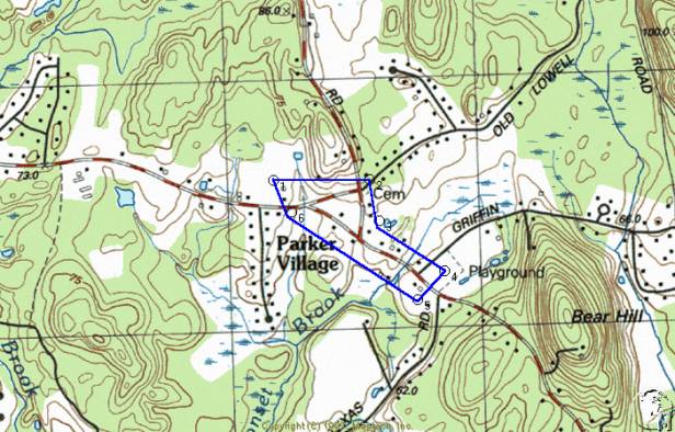
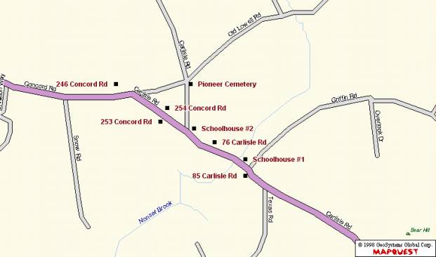
Parker Village (also called Parkerville) developed in the Colonial Period as a farming neighborhood, settled in part by members of the Parker family who came from Westford’s parent town of Chelmsford. The district comprises approximately 33 acres of fields, forest and residential yards. It is bounded on the east by the 1787 Parker Village Schoolhouse at 2 Griffin Road (MHC 125) and on the west by the Balch house at 246 Concord Road (MHC 126). Concord and Carlisle Roads form the principal east-west axis of the agricultural district. A triangular lobe expands the area to the north via the western end of Old Lowell Road. Topographical relief is minimal, providing expansive views across fields planted in hay. Architectural resources include 9 historic residences and two former schoolhouses from the Federal and Late Industrial Periods. Five modern houses also exist. Four former farmhouses have associated barns.
Architectural styles include Federal, Victorian Eclectic, Colonial Revival, Bungalow and Cape Cod. Buildings are located on parcels from one-half to six acres and are primarily wood-framed, although two brick examples exist. Some synthetic materials, such as asbestos and vinyl clapboards have been applied to historic buildings. The Colonial Period Pioneer Burial Ground, containing seven grave markers, occupies the corner of Old Lowell and Carlisle Roads. An historic granite signpost, minus the actual signboard, survives at the corner of Concord and Carlisle Roads. Stone walls and post and rail fences line some edges of the roads and fields. Resources are scattered among farm fields along the 3/4-mile Concord/Carlisle Road corridor which corresponds to a segment of State Route 225. The segment of Old Lowell Road in the district is a less busy, narrower road lined with prominent stone walls. At least two of the historic architectural resources, 253 and 254 Concord Road, have been altered with structural additions and the addition of vinyl siding. Three barns were demolished during the 20th century. The village retains integrity of design, feeling, association, materials and workmanship which makes this one of the town’s best preserved agricultural districts, in contrast to the Graniteville, Forge Village and Brookside industrial districts and the residential and civic district of Westford Center.
The oldest building in Parker Village is the Federal style Parker Village Schoolhouse #1 (MHC 125), located on the corner of Carlisle Road and Griffin Road. Built around 1787 of brick and wood, the former school retains much of its original design intent. It was the subject of a restoration in the early 1990s. The main block, which faces Carlisle Road, is a front-gabled, one and one-half-story, two by two-bay form with a hipped porch attached to the facade. The upper floor is enlarged by a pair of gabled dormers. Windows are primarily 2/2 double-hung sash with some 6/6 sash. Decorative elements include the molded piers supporting the front porch and molded cornice at the eave. The main block is built of brick with wood-framed gable ends clad in wood clapboards. The roof is asphalt shingles and the foundation is cut granite. The plan of the main block is expanded by a rear ell of one story that extends along Griffin Road. The ell is wood construction clad in wood clapboards. A brick chimney rises from the roof ridge of the ell. Windows in the ell are 2/2 double-hung sash with at least one example of a modern 8/8 sash. The attached one and one-half-story barn is built perpendicular to the main block and the ell. The barn is clad in wood shingles laid in stagger-butt pattern. Windows in the facade of the barn are 4/4 double-hung sash. A vehicle door and hay mow door fill the other openings.
The former schoolhouse has been in use as a residence, possibly since the 18th century and certainly sine the 19th. A low stone retaining wall lines the property’s front and east side yards. The building is well maintained.
The Wayland Balch House at 246 Concord Road (MHC 126) was built of brick with elements of the Federal style around 1810. It is a five by one-bay, side-gabled, two and one-half-story building with a two and one-half-story perpendicular ell at the west side that creates an L-shaped plan. One-story, wood-framed ells are attached to the west and north (rear) elevations. Two garage doors fill openings in the shed-roofed west side ell. The north ell is lit by a band of double-hung sash. The L-shaped main block is built of brick with wood trim at the cornice and window sills. Cut granite lintels are over the first story windows and center entry. Windows in the facade have 6/6 double-hung sash. The window over the front entry is enlarged with sidelights, as are those in the east and west side walls. Decorative elements consist of the symmetrical fenestration pattern on the facade, granite lintels, the shallow molded cornice at the eave and sidelights at the front entry. The foundation is built of cut granite and the roof is clad in asphalt shingle. Brick chimneys rise from the west side of the roof and the rear (north) ell. The detached barn in the back yard is a front gambrel form, clad in wood clapboards, built in the early 20th century. The facade, which resembles the barn at 76 Carlisle Road, is two and one-half stories in height with access to the ground floor through a vehicle door. Other openings are filled with double-hung sash. The house is well maintained and is a significant architectural component of the district.
The James Madison Parker House at 85 Carlisle Road is a Victorian Eclectic style residence built around 1850. The main block of the house comprises the western segment of the facade. This is a front-gabled, one and one-half-story, three by two-bay form with a hipped porch covering the side-hall entry. A brick chimney rises from the roofline of the western block. A side-gabled ell of one story expands the plan to the east and is accessed by a door with a modern triangular hood. The ell connects to a one and one-half-story, front-gabled barn with a rolling vehicle door on the ground floor and fixed sash in the gable peak. The front-gabled barn is enlarged at the east by a second attached side-gabled barn, also of one and one-half stories. Swinging doors give access to the interior. The entire building is clad in wood clapboards. Windows have all been replaced with modern 1/1 double-hung sash. Ornament consists of the gable returns, pilasters and molded trim in the front gabled house and barn. Additional brick chimneys rise from the roofs of the ell and second barn. The house is well maintained and retains its original form.
The ca. 1850 Victorian Eclectic style farmhouse at 254 Concord Road is a side-gabled, two and one-half story, five by one-bay form with a perpendicular rear addition and an ell built on the east elevation parallel to the main block. The house is distinguished by its rhythmic fenestration and recessed center entry with sidelights and cornice. Windows have 2/2 and 2/1 double-hung sash. Walls are clad in vinyl clapboards, the roof in asphalt shingles and the foundation is built of cut granite. Brick chimneys rise from the west elevation and from the roof ridge of the ell. The ell is one and one-half story with frieze windows along the front elevation. No frieze or other evidence of Greek Revival style detail is in existence, although these windows may indicate an earlier construction date for this portion of the house. A two and one-half-story, front-gabled barn was attached to the east wall of the ell until structural deterioration forced its demolition in ca. 1995. A detached shed exists east of the house near the road. It is a one story, side-gabled form, built in the early 20th century. Exterior walls are clad in wood clapboards. A single door and two double-hung windows light the south elevation and a vehicle door gives access on the west. The shed is similar in form to the one at 76 Carlisle Road. The house and shed are in fair condition.
The house at 253 Concord Road is a Victorian Eclectic style residence with modern additions. The historic front-gabled, three by two-bay form, built around 1865, is two and one-half stories high. Access is through the recessed side-hall entry. Windows are 6/6 double-hung sash. Decorative elements on the facade include the gable returns, corner pilasters and a molded cornice. The two-story, side-gabled addition at the east elevation, with columns supporting the integral porch, was added in 1969. The two and one-half story addition in the rear was added in the 1990s. The house is clad in wood clapboards, the roof in asphalt shingles and the foundation is built of cut granite and concrete. Stone walls exist in the side and back yards to separate the property from surrounding farm fields. While the house has been enlarged significantly during the Modern Period, the Victorian Eclectic style block retains its design integrity. Like the house across the street at 254 Concord Road, this house had a barn attached to its east side. It was destroyed in the September 1938 hurricane according to a former owner.
The Otis Parker Farmhouse at 76 Carlisle Road is a ca. 1870 Victorian Eclectic style residence with a large attached barn. The main block of the house is a front-gabled, two-story, three by three-bay form with a side-hall entry on the east side of the facade. Walls are clad in wood clapboards, the roof in asphalt shingles and the foundation is built of cut granite. Ornament includes the corner pilasters, molded cornice and recessed entry with sidelights. Windows are 6/6 double-hung sash. A one-story, side-gabled ell expands the plan to the east. Little architectural detail ornaments this portion of the house. Gabled and shed-roofed dormers enlarge the ell and a shed-roofed porch covers a secondary entry. The east end of the ell attaches to the three-story front gambrel barn, clad in novelty board. Openings in the barn facade, which is similar in form to the barn at 246 Concord Road, contain rolling doors and fixed barn-type sash on the ground floor. Fixed and double hung sash fill the openings above. A detached shed built in the early 20th century, located in front of the barn near the street, is a front-gabled, one-story form with swinging doors to access the interior. The side elevations of the shed are lit by fixed sash and the foundation is built of concrete. The shed is similar in form to the one at 254 Concord Road. A post and rail fence lines the front yard. The house, barn and shed are well maintained and contribute a great deal to the agricultural appearance of the neighborhood.
The Parker Village Schoolhouse #2 (MHC 110) is a one and one-half-story, three by four-bay, front-gabled form built in 1880 in the Victorian Eclectic style. It is rectangular in form with a one-story ell at the southeast elevation. A one-story hipped porch, supported by four posts with decorative brackets, is attached to the facade. The building is sided with wood clapboard, the roof is sheathed in asphalt shingles and the foundation is built of cut granite. Ornament at the eaves consists of a frieze and short gable returns. Wall trim takes the form of wood quoins. Four 6/6 double-hung sash on the side walls are trimmed with flat hood moldings. An entry is located at each side of the facade with a double-hung sash between. A recessed panel with flat hood molding is located at the center of the gable at the second story. A brick chimney is attached to the rear elevation and a metal ventilator with pyramidal hipped roof is at the center of the ridgeline. A fence of granite posts and wood rails lines the parking lot at the street. The building was restored as a schoolhouse museum in the mid 1990s and remains in excellent condition. Its site at the corner of Carlisle and Concord Roads is a prominent one in the district.
The Bungalow at 78 Carlisle Road was built around 1930. It is a one-story ridge-hipped form with ells at both the east and west elevations. Exterior walls are clad in wood shingles. Windows are modern vinyl sash. The foundation is concrete. A single brick chimney rises from the roofline. The moderately well-maintained house is shielded from view by the dense growth of lilacs.
The house at 66 Carlisle Road is a two and one-half-story, side-gabled Colonial Revival style design from the 1940s. The Cape Cod house at 257 Concord Road was also built around this time.
The Pioneer Cemetery is located at the southwest corner of Carlisle and Old Lowell Roads and occupies approximately 500 square feet. It comprises seven unmarked stones, two ornamental hemlock trees, a flagpole and stone walls at the edges. A sign reads “Early 1700s Burying Ground Here lies buried members of the Parker & Corey families, James Symons, an Indian, and other early settlers.” The stones are arranged in two short rows with mounds of moss-covered earth between.
At the corner of Concord and Carlisle Roads is a ten-foot granite post formerly used as a signpost. Bolts to hold the sign remain but no sign is in evidence. Other granite resources include the many stone walls built of fieldstone that line Concord, Carlisle and Old Lowell roads throughout the district. Walls on Old Lowell road contributed to its being designated a Scenic Road by the town.
The landscape of Parker Village continues to bear evidence of its agricultural past. Rolling green expanses of hay fields surround the 19th century former agricultural residences. Post and rail fences accompany some stone walls along the field edges. Horses continue to graze in fields on Carlisle Road and Old Lowell Road. The most significant change in Parker Village in the 20th century has been the cessation of almost all farm activity. No cows, chickens, hogs or apples are raised in the district today although hay baling continues. Other changes include the construction of 6 non-agricultural residences since 1950. The loss in the mid 1990s of the large barn at 254 Concord Road signifies the challenges facing farm owners in this increasingly suburban town.
The Parker Village Historic district is eligible for the National Register of Historic Places at the local level. It meets criterion A for its association with trends in agriculture, crop production and raising livestock from the 17th through the 20th centuries. The district meets criterion C for its embodiment of distinctive design characteristics visible in the simple Federal style brick buildings and the Victorian style elements ornamenting wood-framed buildings. Surviving landscape components such as farm fields and stone walls reinforce the historic appearance. The period of significance begins in 1663 with the completion of the road from Chelmsford to Groton that later became the Concord/Carlisle Road segment in the district. The period ends with the transformation of Parker Village in the mid 20th century from an agriculture-based village economy to a residential node on the modern commuter route toward Boston.
Parker Village, located about one mile south of the Westford Center Historic District, was settled in the 17th century by members of the Parker family who migrated to the district from Woburn via Chelmsford, Westford’s parent town. Other Chelmsford residents occupied the vicinity as well, generating a population of approximately five families in the mid 18th century. At that time, according to the 1883 town history, the area was called Nonesuch after the brook by that name (the name of the brook also appears as Nonset). Population increased to around 9 families by the mid 19th century, at least four of which were named Parker. Nearly all residents were involved full time in agriculture while a small number of others adopted work such as butchering and trading.
While it lacked industrial or commercial resources, the neighborhood was typical of other farm villages in the town and region. Early settlers occupied themselves by raising subsistence crops in kitchen gardens, corn and oats for human and livestock consumption and by growing regional cash crops such as fruits, particularly apples for cider. The Framingham and Lowell Railroad maintained a station on their right of way one mile to the east at the corner of Acton and Carlisle Roads. Like other sections of the town, residents were almost entirely of English descent until the mid 1800s when Irish immigrants began to arrive.
Population of the district remained between five and ten families from the Colonial through the Industrial Period. By 1895, however, Louisa was the only landowner named Parker who resided in the village according to property valuations. Agricultural activities continued here until the 1970s when the farm at 254 Concord Road was populated with chickens, dairy cows, horses, and pigs. Hay baling operations continue in the fields.
The District was located along the route from Chelmsford to Groton that was laid out in 1663 according to Chelmsford town records quoted in the 1883 Westford town history. This is now part of Old Lowell, Griffin, Carlisle and Concord Roads, segments of which comprise the southern linear section of the district. In 1722-26, Old Lowell Road was extended west to Concord Road, forming the northwest triangular lobe of the district. No buildings survive from the First Settlement Period. Genealogical information notes that Aaron Parker (1689-1772) was the first member of his family to live in Westford. He had a farm on Old Lowell Road ¼ mile east of the current district boundary. He and his wife Abigail Adams Parker had 10 children, five of whom probably remained in the town during the Colonial Period.
According to historical geographer Douglas R. McManis, food items consumed by New England colonists consisted mainly of corn, wheat, rye, barley, peas and other kitchen garden items such as onions, turnips, carrots, cabbage, fruits and herbs. These items were in addition to the staples of pork and beef. Oats are listed as typical Colonial Period animal fodder. These foodstuffs correspond to census information specific to Parker Village in the 19th century, suggesting diets and crops of area farmers changed little over that time. McManis also indicates that pork-packing became an important industry soon after initial settlement and, in Parker Village, may have endured into the 19th century when a resident was specified as a butcher in the 1865 state census.
According to the map printed in the 1883 town history and purporting to depict Westford in 1730, a house was located within the triangle of land formed by Old Lowell, Carlisle and Concord Roads. This is not the existing house at 254 Concord Road but an earlier home occupied by Samuel Chamberlain (1689-1769) according to the historical notes written by 19th century Parker Village resident May Balch and by Edwin Ruthven Hodgman, 19th century town historian and minister. Mr. Chamberlain, an original First Parish Church member in 1727 and selectman in 1730, at one time owned most of the land in Parker Village. The appearance of his house and its time of demolition are not known. The former Proctor Farm near the site of 76 Carlisle Road is also represented on the map in the town history. This house is depicted in a ca. 1900 photo as a Colonial style, side gabled, two and one-half-story form of five by three bays. Notes with the photo cite a ca. 1700 construction date and state that it was destroyed by fire in 1916. Another house was located at the east end of the district and occupied by three generations of the Minot family. Jonathan (b. ca. 1700) and Elizabeth Minot had grandchildren who attended Harvard University and who served in the Revolutionary War. Their farm and garrison, described as a “big house and barn with a double walled room for protection against Indian raids”, was built in 1723 according to a 1913 local news article quoted in Westford Days. This later became the farm of Gilbert Parker (b. 1796) in the 1820s and burned in 1913. A ca. 1900 photograph depicts a two and one-half-story, three-bay, side-gabled Colonial form with a center brick chimney and two large detached barns. Historic photos of the demolished farms indicate the existence of an architectural form with design characteristics that continued to be built from the Colonial Period through the Early Industrial Period.
The Pioneer Cemetery at the southeast corner of Old Lowell and Carlisle Roads may have been created during the Colonial Period as a small family plot according to a mid-20th century local historian. May Balch, resident of the district until 1897, wrote in 1952 that the cemetery was established “in the early days” of Parker Village history well before her childhood in the 1870s-80s. No inscriptions or official written records exist concerning the burials. Legend states there is a married couple buried here and a stone marking the burial of a person’s arm.
Unlike the densely settled village of Westford Center (MHC Area D) with its commercial and civic activities, or the developing mill villages of Forge Village (MHC Area E) and Graniteville (MHC Area F), Parker Village experienced only scattered residential and agricultural development during the period. Nine farmhouses were spread along ¾ mile of road, an arrangement that was typical for much of the town. The 1787 Parker Village Schoolhouse #1 (MHC 125) on the Groton to Concord Road, also called the Boston Road, (now the corner of Carlisle and Griffin Roads) provided a focus for the linear farming district. This may have been built as a residence for Aaron Parker and used simultaneously for a school. Local historians indicate the brick for the school was fired on Brickyard Hill, one half-mile north of the district. Information from the 1790 federal census indicates six Parker households with a total of 34 family members in the entire town, although only around four of these families lived in the village. The 1830 federal census also lists four Parker households. Other families such as the Minots and Chamberlains continued to reside here.
The 1795 series map depicts in Parker Village the “Road from Groton to Concord” (now State Route 225) and the Road from “Westford to Concord” (now Carlisle Road). The current Old Lowell Road, now one of four Westford Scenic Roads, is not shown although it did exist as a narrow lane (it is still narrower and less traveled than the other two roads). No buildings or industrial installations are noted on the map within the village although there were four houses and associated farm buildings from the previous period. Federal Period development in Parker Village consisted of
the construction of the 1787 Parker Village Schoolhouse #1 at 2 Griffin Road (MHC 125) and the ca. 1810 brick farm house at 246 Concord Road (MHC 126). The schoolhouse was one of four built by the town in that year. The farm house was probably built for Timothy Prescott (b. 1755) who lived here until 1825 when he sold to the farmer George Fletcher (b. 1798). Mr. Fletcher and his descendants occupied the house for over 50 years. A ca. 1900 photograph shows a detached barn in the back yard built perpendicular to the existing barn that later replaced it. The form and condition of the exterior of the older barn indicates it was probably built during the Federal Period. It was demolished or burned in the 20th century. The house and school are the only two surviving examples of brick construction in the district. The brick came from a kiln on what was locally known as Brickyard Hill, located ½ mile north of the district.
Brick construction is rare in the town. In the district of Parker Village there are two examples that both have Federal Period construction dates which indicates a relatively high frequency of brick in a small geographical area and short time span. A brickyard is mentioned in town histories as having existed on Carlisle Road near the former Wilson Farm but little more is known about it. Occurrence of the distinctive building material, while apparent in isolated residential examples elsewhere in Westford, distinguishes the village from others in the town.
No changes to the transportation routes occurred during the period. Concord/Carlisle Road (SR 225) continued to form the southern edge of the district and a segment of Old Lowell Road the northern boundary. The number of residences increased from 5 in 1830 to 9 in 1870 according to historic maps. In 1830, the village consisted of the brick farmhouse at 246 Concord Road (MHC 126) and the C. C. Derby, Samuel Chamberlain, Jonathan Minot and Proctor Houses, the last four of which have been demolished or removed. By 1870, historic maps indicate the addition of the houses at 253 and 254 Concord Road, 85 Carlisle Road and a house now removed near 78 Carlisle Road. The 1787 Parker Village Schoolhouse #1 (MHC 125) remained in use as a school.
Federal census information from 1850 enumerates at least four Parker households and three other families. George Kidder, Nahum Conant, Asa Parline, as well as Gilbert, James M., George A. and Thomas J. Parker all were heads of families in the village according to the 1850 census. Several employed non-family members as hired hands. The state census from both 1855 and 1865 list two households in or near the district that contained Irish-born residents. In 1855, the O’Connors and Gallaghers lived in or near the district and included eight Irish-born residents. In 1865, the O’Toole and McEllacott (also McElligott) families resided between the Temple house on Texas Road, located south of the district and the Minot house (burned in 1913) at the east end of the district. These immigrant families’ homes are not depicted on historic maps and may have been overlooked by 1855 mapmaker Edward Symmes although some do appear as property owners in later tax valuations.
Like most of the town of Westford, the economy of Parker Village was based on agriculture. Residents were farmers except for George A. Parker, a butcher who lived near 76 Carlisle Road and his brother James Madison Parker, occupant of 85 Carlisle Road, who was a trader of unspecified variety. Both were listed as such in the 1865 state census but engaged in some crop raising as well. Nahum Conant was listed as a cooper in the 1850 federal census. George Kidder, resident of 253 Concord Road was typical of Parker Village farmers at that time. He was taxed in 1860 for raising two dairy cows, three horses and two oxen on 67 1/2 acres of meadow and fields. Crops and produce at the Kidder farm included corn, oats, peas and beans, Irish (as opposed to sweet) potatoes, butter, hay and slaughtered animals. These items were typical for the district with some residents engaging in raising orchards, making cheese and raising market garden crops. After the arrival of the Framingham and Lowell Railroad with a station one mile to the east, milk production among the villagers increased drastically. George Fletcher, a more successful farmer, occupied the house at 246 Concord Road (MHC 126). He owned 142 acres, two oxen, two cows and seven horses. The wealthiest resident of the village was Gilbert Parker, father of George A. and James M. Parker, who occupied the Minot Farm until his death in 1874. In 1860 Mr. Parker owned 215 acres, two oxen, seven cows, three horses, stock in two railroads and had money at interest. His estate was comparable to the town doctor and other wealthy residents of affluent Westford Center (MHC Area D). The member of the neighborhood with the lowest property valuation was the trader James Madison Parker who lived at 85 Carlisle Road, and owned nine acres.
Architecture from the Early Industrial Period includes the Victorian Eclectic style farms at 253 Concord Road, 254
Concord Road and 85 Carlisle Road,
all built between 1840-1855. Barns were
built with all these homes although the only example to escape demolition is at
85 Carlisle Road.
Wood-framed construction of
farmhouses in the Victorian Eclectic style was common in the agricultural town
of Westford and historic examples survive in most areas. Parker Village’s Early Industrial
architecture is representative of these period resources and are more well
preserved than others in the town in terms of materials, design and setting.
The transportation network in Parker Village was complete by 1870. The 1875 county atlas indicates that a dirt lane led south from the intersection of Carlisle and Concord Roads to a farm field. The lane is still in existence, used in part as a driveway for the house at 77 Carlisle Road. The granite signpost at the corner of Carlisle and Concord Roads was erected during this period. The town began maintaining “guide boards” or road signs in the 1890s.
The population of Parker Village did not change significantly from the Early to Late Industrial Periods. Nine houses and the schoolhouse existed within the district in 1870. One new house, 76 Carlisle Road, was built between 1870 and 1915. The 1889 Walker map also depicts a residence, about which little is known, west of the house at 253 Concord Road. It has since been demolished or removed. In 1874, the town built a new district schoolhouse ¼ mile west of the 1787 Parker Village Schoolhouse #1 (MHC 125). The new schoolhouse burned in 1880 and was replaced in that year with the existing Parker Village Schoolhouse #2 (MHC 110) at the corner of Carlisle and Concord Roads. According to annual town reports, the architect for the new school was E. A. Stevens and the builder was Jonathan Larcom. Also, local historians believe the foundation as well as some windows and doors from the burned building were reused. A well was dug for the schoolhouse in 1884. George A. Parker bought the 1787 schoolhouse in 1874 and may have used it to house his butcher shop. C. H. Keyes owned the former school in 1889. For a short period in the late 1890s, the former school functioned as a meeting and dance hall. The So. Westford Social Club met here in 1896 and 1897 for whist games, violin music, dancing, refreshments and sleigh rides. Activities of the club are described in weekly notes or meeting minutes kept by May Balch, resident of 246 Concord Road.
Economic activity continued to be based almost completely on farming with some small non-agricultural operations. For example, in 1885, the owner of the farm at 246 Concord Road, Wayland Balch, paid tax on a shop of unspecified nature. Also, the town road and bridge report for that year lists Mr. Balch as being paid to repair Brickyard Hill Road, reference to a supplemental means of income and to industrial activity carried on just north of the district. Taxable crops commonly consisted of corn, apples and hay. Local residents recall picking berries, several varieties of fruits and at least one Westford resident outside Parker Village was assessed for ownership of a vineyard suggesting additional depth to the types of crops grown in town. Other crops were surely grown but did not appear in valuations. Westford Grange #208 was formed in 1895 and met in Westford Center.
Architecture from the Late Industrial Period includes the Otis W. Parker Farm at 76 Carlisle Road. The most ornate part of the house is the western end of the building, which has Victorian Eclectic style architectural detail, although the barn’s front-gambrel form appears to have been built early in the 20th century.
The Otis Parker Farm and the Parker Village Schoolhouse #2 are indicative of the wood-framed methods of construction and Victorian style design characteristics in existence throughout the town. A significant loss in terms of architecture was the ca. 1723 Minot Farm formerly located at the corner of Texas and Carlisle Roads across from 85 Carlisle Road. A 1913 news article in the Westford Wardsman laments at some length the destruction by fire of what may have been a garrison with hidden interior chambers for defense from Native Americans.
At the beginning of the Modern Period, the economy of Parker Village was an agriculture-based system composed of small farms raising hay, corn, dairy cows, apples, chickens and produce for local consumption. By the mid 20th century, the district had changed to a suburban neighborhood of residents who commuted to jobs outside the area. Indicative of changes in the economy of the district was the demolition of the large chestnut framed attached barn at 254 Concord Road. Used to house cows and hay until approximately 1980, the barn deteriorated to the point where it could no longer be safely occupied and was taken down in 1995. The hurricane of September, 1938 destroyed the barn at 253 Concord Road according to a former owner. The Colonial Period Proctor Farm that was built near the site of 76 Carlisle Road in ca. 1700 burned in 1916 according to a contemporary news account. The schoolhouse at the corner of Carlisle and Concord Roads remained in use until 1928 when the district primary schools were consolidated in Westford Center (MHC Area D). The building was later used as a clubhouse. In recent years, it has been renovated and used as a living classroom of the early 20th century, attended by all Westford third graders, and as a meeting place for scouts and other community organizations. Concord Road was called Boston Road until the 1930s, indicating its vestigial importance as a through travel route.
Buildings that were constructed during the period include the Cape Cod house and attached garage at 257 Concord Road. The house at 66 Carlisle Road was built ca. 1940. Houses at 68, 77, 80 and 81 Carlisle Road and 2 Old Lowell Road were built between 1960 and 1990.
The historical appearance and associations of Parker Village remain intact by virtue of its surviving fields and former farm houses. While some historic buildings have been altered, many continue to bear the exterior materials and architectural design elements of the original construction. The Pioneer Cemetery serves as the final resting place for early settlers of the area. Some new construction has occurred but not to the extreme detriment of the existing historic fabric. Perhaps the most evocative surviving components of the village’s past are the fields and stone walls that line the sides of Concord, Carlisle and Old Lowell Roads throughout the district and the Parker Village district school house which serves as a living museum and also still serves as a focal point for local events.
Sketch Map North Toward Top
Sketch Map North Toward Top
The Parker Village Historic District is comprised of segments of three roads: Concord Road from the house at 246 Concord Road to its terminus at the junction of Carlisle Road; Carlisle Road from the corner of Old Lowell Road to the house at 85 Carlisle Road; Old Lowell Road from Carlisle Road to Concord Road. The boundaries encompass approximately 33 acres on which are located historic former farmhouses, barns, two former schoolhouses, a cemetery and a signpost.
The boundaries of the Parker Village Historic District were selected for their demarcation of the limits of the historic resources of the village. Beyond the boundaries are increasing numbers of modern residences and less frequent evidence of the area’s agricultural past. The examples of agricultural landscapes with associated residences on Concord, Carlisle and Old Lowell Roads retain integrity of materials, design and setting. The former J. M. Parker farmhouse and barns as well as the 1787 District No. 5 Schoolhouse mark the eastern boundary of the district. The Wayland Balch house is one of a small number of remaining Federal Period Brick houses in the town and marks the western boundary of the district. Resources between are arranged largely in linear fashion and include additional residences, barns and stone walls, school houses, an historic granite signpost and a Colonial Period burial ground at the northeast corner.